
Seller's Agent in 2025
Sasha Braden
Chapman Group Realty, Inc.
(404) 667-0936
22 in this area
98 Total Sales
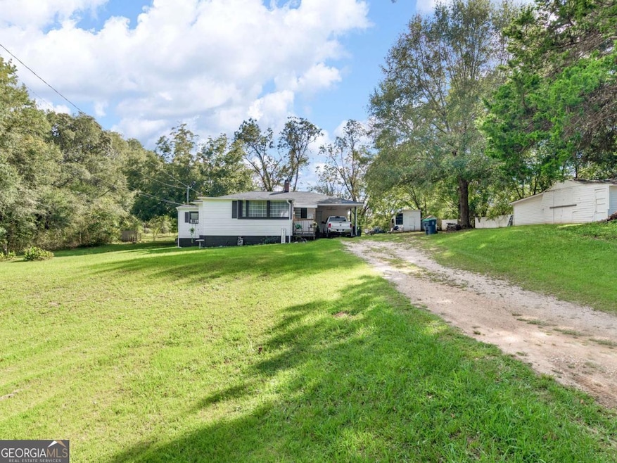
Discover the perfect blend of modern updates and country charm in this 3-bedroom, 2-bath home, nestled on 1.25 acres with NO HOA! Conveniently located less than 15 minutes from I-75, shopping, and dining, this home offers both tranquility and accessibility. Step inside to a spacious family room, ideal for relaxing and entertaining. The updated kitchen boasts stainless steel appliances, a stylish tile backsplash, a center island, and a cozy breakfast nook. A separate formal dining room provides the perfect setting for family gatherings. The owner's suite is a true retreat, featuring dual closets and an oversized tiled bathroom complete with a luxurious jetted tub. One of the secondary bedrooms includes a large sitting area, making it ideal as a nursery, home gym, or office. The third bedroom, conveniently located off the kitchen, is currently used as an office. Additional highlights include a mudroom with potential for an office, pantry, or extra storage, as well as a laundry space with ample cabinetry. Several upgrades have been made throughout, including newer carpet, fresh paint, water heater, and a newer roof. Step outside to enjoy a backyard basketball court, perfect for recreation and entertainment ~ Sell with Sasha!
Last Agent to Sell the Property
Chapman Group Realty, Inc. License #375572 Listed on: 06/17/2025
| Date | Type | Sale Price | Title Company |
|---|---|---|---|
| Limited Warranty Deed | $225,000 | -- | |
| Warranty Deed | $70,000 | -- | |
| Warranty Deed | $55,000 | -- | |
| Warranty Deed | -- | -- | |
| Warranty Deed | $27,500 | -- | |
| Foreclosure Deed | -- | -- |
| Date | Status | Loan Amount | Loan Type |
|---|---|---|---|
| Open | $220,924 | New Conventional |
| Date | Event | Price | List to Sale | Price per Sq Ft |
|---|---|---|---|---|
| 07/16/2025 07/16/25 | Sold | $225,000 | +0.2% | $260 / Sq Ft |
| 06/17/2025 06/17/25 | Pending | -- | -- | -- |
| 06/17/2025 06/17/25 | For Sale | $224,500 | -- | $260 / Sq Ft |
| Year | Tax Paid | Tax Assessment Tax Assessment Total Assessment is a certain percentage of the fair market value that is determined by local assessors to be the total taxable value of land and additions on the property. | Land | Improvement |
|---|---|---|---|---|
| 2025 | $3,784 | $94,720 | $15,640 | $79,080 |
| 2024 | $3,784 | $62,600 | $14,120 | $48,480 |
| 2023 | $1,114 | $28,000 | $6,692 | $21,308 |
| 2022 | $271 | $44,320 | $12,560 | $31,760 |
| 2021 | $236 | $35,440 | $10,760 | $24,680 |
| 2020 | $244 | $36,360 | $10,120 | $26,240 |
| 2019 | $223 | $31,520 | $9,600 | $21,920 |
| 2018 | $211 | $28,480 | $8,880 | $19,600 |
| 2016 | $683 | $16,760 | $6,920 | $9,840 |
| 2015 | $589 | $13,880 | $7,040 | $6,840 |
| 2014 | $554 | $12,840 | $7,040 | $5,800 |
Seller's Agent in 2025
Sasha Braden
Chapman Group Realty, Inc.
(404) 667-0936
22 in this area
98 Total Sales
Buyer's Agent in 2025
Evan Stalcup
Atlanta Communities
(678) 615-9658
2 in this area
136 Total Sales
Source: Georgia MLS
MLS Number: 10545695
APN: 0143-01-025-000
Disclaimer: Certain information contained herein is derived from information provided by parties other than Homes.com. All information provided is deemed reliable, but is not guaranteed to be accurate and should be independently verified.
![]() The data relating to real estate for sale on this web site comes in part from the Broker Reciprocity Program of Georgia MLS. Real estate listings held by brokerage firms other than Redfin are marked with the Broker Reciprocity logo and detailed information about them includes the name of the listing brokers. Information deemed reliable but not guaranteed. Copyright 2025 Georgia MLS. All rights reserved.
The data relating to real estate for sale on this web site comes in part from the Broker Reciprocity Program of Georgia MLS. Real estate listings held by brokerage firms other than Redfin are marked with the Broker Reciprocity logo and detailed information about them includes the name of the listing brokers. Information deemed reliable but not guaranteed. Copyright 2025 Georgia MLS. All rights reserved.