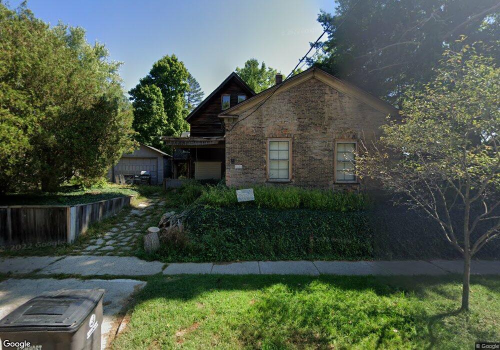
1202 Traver Rd Ann Arbor, MI 48105
Northern Ann Arbor NeighborhoodEstimated Value: $619,000 - $759,043
3
Beds
3
Baths
2,817
Sq Ft
$237/Sq Ft
Est. Value
About This Home
This home is located at 1202 Traver Rd, Ann Arbor, MI 48105 and is currently estimated at $667,011, approximately $236 per square foot. 1202 Traver Rd is a home located in Washtenaw County with nearby schools including Ann Arbor STEAM at Northside, Clague Middle School, and Skyline High School.
Ownership History
Date
Name
Owned For
Owner Type
Purchase Details
Closed on
Nov 17, 1995
Sold by
Cotman Robert J
Bought by
Stulberg Thomas M
Current Estimated Value
Home Financials for this Owner
Home Financials are based on the most recent Mortgage that was taken out on this home.
Original Mortgage
$72,000
Outstanding Balance
$834
Interest Rate
5.75%
Mortgage Type
New Conventional
Estimated Equity
$666,177
Create a Home Valuation Report for This Property
The Home Valuation Report is an in-depth analysis detailing your home's value as well as a comparison with similar homes in the area
Home Values in the Area
Average Home Value in this Area
Purchase History
| Date | Buyer | Sale Price | Title Company |
|---|---|---|---|
| Stulberg Thomas M | $80,000 | -- |
Source: Public Records
Mortgage History
| Date | Status | Borrower | Loan Amount |
|---|---|---|---|
| Open | Stulberg Thomas M | $72,000 |
Source: Public Records
Tax History Compared to Growth
Tax History
| Year | Tax Paid | Tax Assessment Tax Assessment Total Assessment is a certain percentage of the fair market value that is determined by local assessors to be the total taxable value of land and additions on the property. | Land | Improvement |
|---|---|---|---|---|
| 2025 | $9,055 | $344,100 | $0 | $0 |
| 2024 | $8,432 | $333,300 | $0 | $0 |
| 2023 | $9,055 | $306,900 | $0 | $0 |
| 2022 | $7,250 | $297,800 | $0 | $0 |
| 2021 | $8,272 | $288,400 | $0 | $0 |
| 2020 | $8,105 | $285,800 | $0 | $0 |
| 2019 | $7,714 | $250,100 | $250,100 | $0 |
| 2018 | $7,605 | $221,600 | $0 | $0 |
| 2017 | $7,398 | $209,400 | $0 | $0 |
| 2016 | $6,302 | $147,937 | $0 | $0 |
| 2015 | $6,797 | $147,495 | $0 | $0 |
| 2014 | $6,797 | $142,887 | $0 | $0 |
| 2013 | -- | $142,887 | $0 | $0 |
Source: Public Records
Map
Nearby Homes
- 539 Longshore Dr Unit 46
- 519 Longshore Dr Unit A
- 1136 Longshore Dr Unit 1
- 1128 Longshore Dr Unit 1
- 1128 Longshore Dr Unit 2
- 408 Longshore Dr Unit A
- 408 Longshore Dr Unit C
- 1183 Freesia Ct Unit 52
- 1050 Wall St Unit 5D
- 1050 Wall St Unit 8D
- 1050 Wall St Unit 5A
- 1050 Wall St Unit 2C
- 1050 Wall St Unit 3C
- 1050 Wall St Unit 4A
- 1201 Island Dr Unit 104
- 1245 Island Dr Unit 102
- 1540 Jones Dr
- 1558 Jones Dr
- 1261 Island Dr Unit 201
- 330 Detroit St Unit 101
- 1206 Traver Rd
- 1211 Traver Rd
- 1141 Traver Rd
- 1202 Pontiac Trail
- 1219 Traver Rd
- 1137 Traver Rd
- 1223 Traver Rd
- 1208 Pontiac Trail
- 1214 Pontiac Trail
- 700 Bowen St
- 1131 Traver Rd
- 1220 Pontiac Trail
- 1229 Traver Rd
- 1128 Pontiac Trail
- 1226 Pontiac Trail
- 1127 Traver Rd
- 1230 Traver Rd
- 1207 Broadway St Unit 11
- 1209 Broadway St Unit 12
- 1118 Pontiac Trail