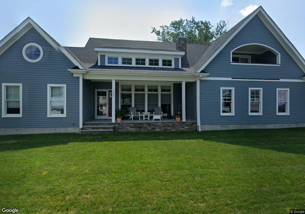
1203 Anthony Rd Portsmouth, RI 02871
Common Fence Point NeighborhoodEstimated Value: $848,000 - $1,300,000
3
Beds
3
Baths
2,038
Sq Ft
$547/Sq Ft
Est. Value
About This Home
This home is located at 1203 Anthony Rd, Portsmouth, RI 02871 and is currently estimated at $1,115,144, approximately $547 per square foot. 1203 Anthony Rd is a home with nearby schools including Portsmouth High School.
Ownership History
Date
Name
Owned For
Owner Type
Purchase Details
Closed on
May 27, 2016
Sold by
Spier Gregory P and Crane-Spier Kathryn
Bought by
Casemira Peter A
Current Estimated Value
Home Financials for this Owner
Home Financials are based on the most recent Mortgage that was taken out on this home.
Original Mortgage
$130,800
Outstanding Balance
$56,850
Interest Rate
2.86%
Mortgage Type
New Conventional
Estimated Equity
$1,058,294
Purchase Details
Closed on
Feb 25, 2009
Sold by
Kenney Christopher P
Bought by
Spier Gregory P and Crane-Spier Kathryn
Create a Home Valuation Report for This Property
The Home Valuation Report is an in-depth analysis detailing your home's value as well as a comparison with similar homes in the area
Home Values in the Area
Average Home Value in this Area
Purchase History
| Date | Buyer | Sale Price | Title Company |
|---|---|---|---|
| Casemira Peter A | $217,500 | -- | |
| Spier Gregory P | $160,000 | -- |
Source: Public Records
Mortgage History
| Date | Status | Borrower | Loan Amount |
|---|---|---|---|
| Open | Casemira Peter A | $130,800 |
Source: Public Records
Tax History Compared to Growth
Tax History
| Year | Tax Paid | Tax Assessment Tax Assessment Total Assessment is a certain percentage of the fair market value that is determined by local assessors to be the total taxable value of land and additions on the property. | Land | Improvement |
|---|---|---|---|---|
| 2025 | $11,417 | $859,700 | $342,700 | $517,000 |
| 2024 | $11,331 | $859,700 | $342,700 | $517,000 |
| 2023 | $10,987 | $859,700 | $342,700 | $517,000 |
| 2022 | $9,238 | $593,700 | $251,000 | $342,700 |
| 2021 | $9,090 | $593,700 | $251,000 | $342,700 |
| 2020 | $9,223 | $612,000 | $251,000 | $361,000 |
| 2019 | $8,784 | $535,600 | $206,800 | $328,800 |
| 2018 | $6,190 | $387,600 | $206,800 | $180,800 |
| 2017 | $4,459 | $289,200 | $206,800 | $82,400 |
| 2016 | $3,106 | $194,100 | $193,100 | $1,000 |
| 2015 | $3,067 | $194,100 | $193,100 | $1,000 |
| 2014 | $3,067 | $194,100 | $193,100 | $1,000 |
Source: Public Records
Map
Nearby Homes
- 1350 Anthony Rd
- 1055 Anthony Rd
- 0 Island Rd
- 0 Common Fence Blvd Unit 1364650
- 0 Common Fence Blvd Unit 1397142
- 169 Narragansett Blvd
- 134 Greenfield Ave
- 10 Mount Hope Ave
- 72 Rhode Island Blvd
- 0 Dighton Ave
- 83 Waters Edge Unit 24
- 87 Waters Edge
- 171 Leeshore Ln
- 42 Lewis St
- 47 Watermark Dr
- 9 Cutter Ln
- 24 Bismark Ave
- 8 Tucker Ave
- 15 Rocky Ave
- 50 Stevens St
- 1189 Anthony Rd
- 1217 Anthony Rd
- 54 Narragansett Rd
- 44 Narragansett Rd
- 1206 Anthony Rd
- 58 Narragansett Rd
- 1194 Anthony Rd
- 1179 Anthony Rd
- 1190 Anthony Rd
- 1171 Anthony Rd
- 1188 Anthony Rd
- 36 Narragansett Rd
- 1184 Anthony Rd
- 1226 Anthony Rd
- 59 Narragansett Rd
- 1225 Anthony Rd
- 51 Narragansett Rd
- 33 Narragansett Rd
- 55 Narragansett Rd
- 57 Narragansett Rd