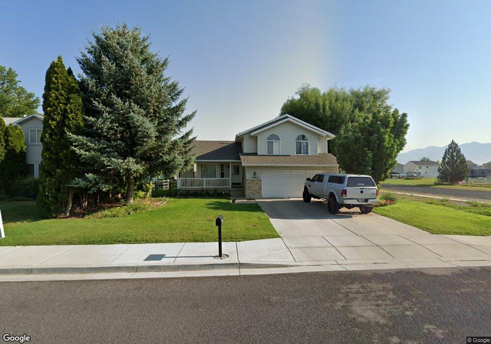
1203 W 350 S Logan, UT 84321
Woodruff NeighborhoodEstimated Value: $447,087 - $483,000
3
Beds
3
Baths
1,824
Sq Ft
$256/Sq Ft
Est. Value
About This Home
This home is located at 1203 W 350 S, Logan, UT 84321 and is currently estimated at $466,522, approximately $255 per square foot. 1203 W 350 S is a home located in Cache County with nearby schools including Woodruff School, Mount Logan Middle School, and Logan High School.
Ownership History
Date
Name
Owned For
Owner Type
Purchase Details
Closed on
May 20, 2025
Sold by
Gunn Jason and Gunn Brandy Dawn
Bought by
Gunn Jason
Current Estimated Value
Purchase Details
Closed on
Oct 20, 2022
Sold by
Gunn Jason
Bought by
Gunn Jason and Gunn Brandy Dawn
Purchase Details
Closed on
Jun 22, 2016
Sold by
Gunn Jason
Bought by
Gunn Jason and Jason Gunn Revocable Living Tr
Purchase Details
Closed on
May 11, 2012
Sold by
Simmons Richard C and Simmons Linda G
Bought by
Gunn Jason
Purchase Details
Closed on
Mar 1, 2005
Sold by
Herring Willina Joyce and The Willina Joyce Herring Revo
Bought by
Simmons Richard C and Simmons Lida G
Home Financials for this Owner
Home Financials are based on the most recent Mortgage that was taken out on this home.
Original Mortgage
$130,800
Interest Rate
5.66%
Mortgage Type
New Conventional
Purchase Details
Closed on
Feb 16, 2001
Sold by
Herring Dale T
Bought by
Herring Dale T and Dale T Herring Trust
Create a Home Valuation Report for This Property
The Home Valuation Report is an in-depth analysis detailing your home's value as well as a comparison with similar homes in the area
Home Values in the Area
Average Home Value in this Area
Purchase History
| Date | Buyer | Sale Price | Title Company |
|---|---|---|---|
| Gunn Jason | -- | Northern Title | |
| Gunn Jason | -- | Northern Title | |
| Gunn Jason | -- | Northern Title Company | |
| Gunn Jason | -- | None Available | |
| Gunn Jason | -- | Pinnacle Title Ins Agency | |
| Simmons Richard C | -- | Cache Title Company | |
| Herring Dale T | -- | -- |
Source: Public Records
Mortgage History
| Date | Status | Borrower | Loan Amount |
|---|---|---|---|
| Previous Owner | Simmons Richard C | $130,800 |
Source: Public Records
Tax History Compared to Growth
Tax History
| Year | Tax Paid | Tax Assessment Tax Assessment Total Assessment is a certain percentage of the fair market value that is determined by local assessors to be the total taxable value of land and additions on the property. | Land | Improvement |
|---|---|---|---|---|
| 2025 | $1,704 | $220,365 | $0 | $0 |
| 2024 | $1,751 | $219,395 | $0 | $0 |
| 2023 | $1,817 | $217,010 | $0 | $0 |
| 2022 | $1,581 | $176,310 | $0 | $0 |
| 2021 | $1,561 | $268,850 | $62,000 | $206,850 |
| 2020 | $1,429 | $221,517 | $62,000 | $159,517 |
| 2019 | $1,493 | $221,516 | $62,000 | $159,516 |
| 2018 | $1,482 | $200,710 | $62,000 | $138,710 |
| 2017 | $1,387 | $99,330 | $0 | $0 |
| 2016 | $1,438 | $99,330 | $0 | $0 |
| 2015 | $1,307 | $90,135 | $0 | $0 |
| 2014 | $1,181 | $90,135 | $0 | $0 |
| 2013 | -- | $90,135 | $0 | $0 |
Source: Public Records
Map
Nearby Homes
- 1271 W 350 S
- 370 S 1200 W Unit 2
- 1099 Three Pointe Ave
- 1177 130 S
- 248 Sunstone Ct
- 1227 W 500 S Unit 151
- 506 S 1225 W
- 518 S 1225 W
- 542 S 1225 W Unit 116
- 548 S 1225 W Unit 115
- Hemlock Plan at Sugar Creek - Logan
- Eucalyptus Plan at Sugar Creek - Logan
- Blackberry Plan at Sugar Creek - Logan
- Magnolia Plan at Sugar Creek - Logan
- 2399 W 430 S Unit 33
- 1239 W 575 S Unit 152
- 1239 W 575 S
- 542 1225 W
- 1220 W 575 S
- Redwood Plan at Rivergate - Logan