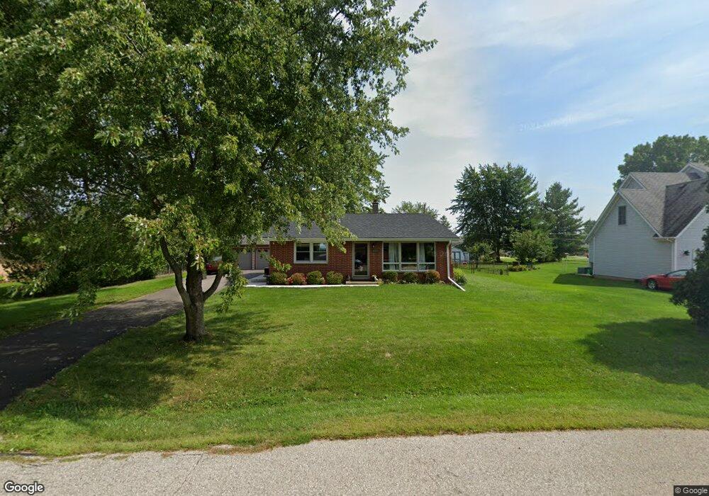
12039 44th Ave Pleasant Prairie, WI 53158
Village of Pleasant Prairie NeighborhoodEstimated Value: $278,000 - $341,000
3
Beds
2
Baths
1,428
Sq Ft
$219/Sq Ft
Est. Value
About This Home
This home is located at 12039 44th Ave, Pleasant Prairie, WI 53158 and is currently estimated at $312,427, approximately $218 per square foot. 12039 44th Ave is a home located in Kenosha County with nearby schools including Prairie Lane Elementary School, Lance Middle School, and Tremper High School.
Ownership History
Date
Name
Owned For
Owner Type
Purchase Details
Closed on
Jun 28, 2018
Sold by
Miller Matthew and Miller Anna
Bought by
Neill James O and Neill Lorraine O
Current Estimated Value
Home Financials for this Owner
Home Financials are based on the most recent Mortgage that was taken out on this home.
Original Mortgage
$163,827
Outstanding Balance
$142,759
Interest Rate
4.75%
Mortgage Type
FHA
Estimated Equity
$169,668
Create a Home Valuation Report for This Property
The Home Valuation Report is an in-depth analysis detailing your home's value as well as a comparison with similar homes in the area
Home Values in the Area
Average Home Value in this Area
Purchase History
| Date | Buyer | Sale Price | Title Company |
|---|---|---|---|
| Neill James O | $178,900 | None Available |
Source: Public Records
Mortgage History
| Date | Status | Borrower | Loan Amount |
|---|---|---|---|
| Open | Neill James O | $163,827 |
Source: Public Records
Tax History Compared to Growth
Tax History
| Year | Tax Paid | Tax Assessment Tax Assessment Total Assessment is a certain percentage of the fair market value that is determined by local assessors to be the total taxable value of land and additions on the property. | Land | Improvement |
|---|---|---|---|---|
| 2024 | $2,783 | $251,600 | $75,100 | $176,500 |
| 2023 | $2,718 | $216,400 | $68,300 | $148,100 |
| 2022 | $2,775 | $216,400 | $68,300 | $148,100 |
| 2021 | $3,083 | $174,500 | $55,100 | $119,400 |
| 2020 | $3,169 | $174,500 | $55,100 | $119,400 |
| 2019 | $2,893 | $174,500 | $55,100 | $119,400 |
| 2018 | $2,957 | $174,500 | $55,100 | $119,400 |
| 2017 | $3,263 | $151,200 | $50,200 | $101,000 |
| 2016 | $3,222 | $151,200 | $50,200 | $101,000 |
| 2015 | $2,804 | $143,800 | $47,800 | $96,000 |
| 2014 | -- | $143,800 | $47,800 | $96,000 |
Source: Public Records
Map
Nearby Homes
- Lt0 39th Ave
- Lt0 128th St
- Deerfield Plan at Cedar Ridge
- Essex Plan at Cedar Ridge
- Geneva Plan at Cedar Ridge
- Ellington Plan at Cedar Ridge
- Summerhill Plan at Cedar Ridge
- Harlow Plan at Cedar Ridge
- Norwood Plan at Cedar Ridge
- Andover Plan at Cedar Ridge
- Glenwood Plan at Cedar Ridge
- Berkshire Plan at Cedar Ridge
- Sinclair Plan at Cedar Ridge
- Waterford Plan at Cedar Ridge
- Ashford Plan at Cedar Ridge
- Brighton Plan at Cedar Ridge
- Windsor Plan at Cedar Ridge
- Danbury Plan at Cedar Ridge
- Hawthorne Plan at Cedar Ridge
- Brookhaven Plan at Cedar Ridge