Estimated Value: $335,000 - $391,000
3
Beds
2
Baths
1,500
Sq Ft
$248/Sq Ft
Est. Value
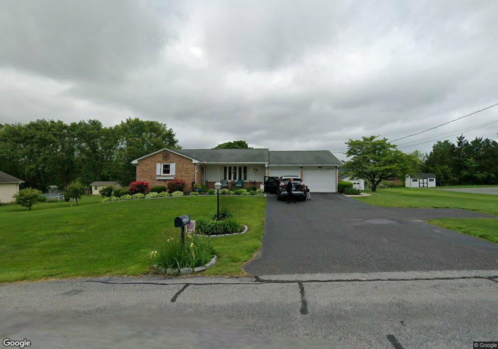
About This Home
This home is located at 1204 Station Rd, Palm, PA 18070 and is currently estimated at $372,678, approximately $248 per square foot. 1204 Station Rd is a home located in Montgomery County with nearby schools including Upper Perkiomen 4th & 5th Grade Center, Upper Perkiomen Middle School, and Upper Perkiomen High School.
Ownership History
Date
Name
Owned For
Owner Type
Purchase Details
Closed on
Aug 5, 2013
Sold by
Marks Harold S
Bought by
Wimmer Derik and Siwert Gabrielle
Current Estimated Value
Home Financials for this Owner
Home Financials are based on the most recent Mortgage that was taken out on this home.
Original Mortgage
$188,097
Outstanding Balance
$140,548
Interest Rate
4.51%
Mortgage Type
New Conventional
Estimated Equity
$232,130
Purchase Details
Closed on
Nov 29, 2001
Sold by
Marks Harold S and Marks Pauline R
Bought by
The Marks Trust and Marks Harold S
Create a Home Valuation Report for This Property
The Home Valuation Report is an in-depth analysis detailing your home's value as well as a comparison with similar homes in the area
Home Values in the Area
Average Home Value in this Area
Purchase History
| Date | Buyer | Sale Price | Title Company |
|---|---|---|---|
| Wimmer Derik | $205,000 | None Available | |
| The Marks Trust | -- | -- |
Source: Public Records
Mortgage History
| Date | Status | Borrower | Loan Amount |
|---|---|---|---|
| Open | Wimmer Derik | $188,097 |
Source: Public Records
Tax History Compared to Growth
Tax History
| Year | Tax Paid | Tax Assessment Tax Assessment Total Assessment is a certain percentage of the fair market value that is determined by local assessors to be the total taxable value of land and additions on the property. | Land | Improvement |
|---|---|---|---|---|
| 2025 | $4,313 | $128,670 | $43,510 | $85,160 |
| 2024 | $4,313 | $128,670 | $43,510 | $85,160 |
| 2023 | $4,109 | $128,670 | $43,510 | $85,160 |
| 2022 | $4,053 | $128,670 | $43,510 | $85,160 |
| 2021 | $3,950 | $128,670 | $43,510 | $85,160 |
| 2020 | $3,928 | $128,670 | $43,510 | $85,160 |
| 2019 | $3,839 | $128,670 | $43,510 | $85,160 |
| 2018 | $3,840 | $128,670 | $43,510 | $85,160 |
| 2017 | $3,723 | $128,670 | $43,510 | $85,160 |
| 2016 | $3,674 | $128,670 | $43,510 | $85,160 |
| 2015 | $3,467 | $128,670 | $43,510 | $85,160 |
| 2014 | $3,467 | $128,670 | $43,510 | $85,160 |
Source: Public Records
Map
Nearby Homes
- 770 Gravel Pike
- 2012 Corning Rd
- 7921 Corning Rd
- 1962 Tollgate Rd
- 2060 Adams Rd
- 2037 Bethesda Church Rd
- 2020 Peevy Rd
- 62 Ashford Ln
- 328 Ashford Ln
- 166 Liberty Cir
- 192 Lexington Dr
- 2 Standish Ln
- 320 Ashford Ln
- 317 Ashford Ln
- 516 Colonial Dr
- 725 Valley Rd
- 444 Colonial Dr
- 333 Blaker Dr
- 317 State St
- 222 Cherry St
- 1201 Station Rd
- 1207 Station Rd
- 1195 Station Rd
- 1206 Station Rd
- 1198 Station Rd
- 1212 Station Rd
- 1189 Station Rd
- 1192 Station Rd
- 1185 Station Rd
- 1184 Station Rd
- 1181 Station Rd
- 1180 Station Rd
- 1173 Station Rd
- 1176 Station Rd
- 1176 Station Rd
- 1169 Station Rd
- 0 Station Rd Unit 6657589
- 1168 Station Rd
- 1161 Station Rd
- 1158 Station Rd