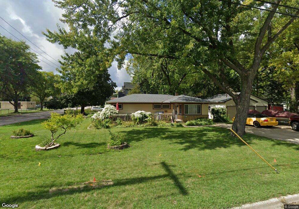
1205 Clay St Woodstock, IL 60098
Estimated Value: $205,590 - $235,000
--
Bed
--
Bath
976
Sq Ft
$231/Sq Ft
Est. Value
About This Home
This home is located at 1205 Clay St, Woodstock, IL 60098 and is currently estimated at $225,398, approximately $230 per square foot. 1205 Clay St is a home located in McHenry County with nearby schools including Westwood Elementary School, Northwood Middle School, and Woodstock North High School.
Ownership History
Date
Name
Owned For
Owner Type
Purchase Details
Closed on
Sep 17, 2025
Sold by
Randels Timothy W
Bought by
Timothy Randels Revocable Trust and Randels
Current Estimated Value
Purchase Details
Closed on
May 17, 2002
Sold by
Randels Deborah L Bailey and Randels Timothy W
Bought by
Randels Timothy W
Purchase Details
Closed on
Jul 1, 1997
Sold by
Bailey Randels Deborah L and Dean Deborah L
Bought by
Bailey Randels Deborah L and Randels Timothy W
Purchase Details
Closed on
Jan 30, 1997
Sold by
Dean Gordon P and Dean Deborah L
Bought by
Dean Deborah L
Create a Home Valuation Report for This Property
The Home Valuation Report is an in-depth analysis detailing your home's value as well as a comparison with similar homes in the area
Home Values in the Area
Average Home Value in this Area
Purchase History
| Date | Buyer | Sale Price | Title Company |
|---|---|---|---|
| Timothy Randels Revocable Trust | -- | None Listed On Document | |
| Randels Timothy W | -- | -- | |
| Bailey Randels Deborah L | -- | -- | |
| Dean Deborah L | -- | -- |
Source: Public Records
Tax History Compared to Growth
Tax History
| Year | Tax Paid | Tax Assessment Tax Assessment Total Assessment is a certain percentage of the fair market value that is determined by local assessors to be the total taxable value of land and additions on the property. | Land | Improvement |
|---|---|---|---|---|
| 2024 | $5,713 | $69,409 | $10,703 | $58,706 |
| 2023 | $5,483 | $63,474 | $9,788 | $53,686 |
| 2022 | $5,325 | $57,035 | $8,795 | $48,240 |
| 2021 | $5,032 | $53,066 | $8,183 | $44,883 |
| 2020 | $4,825 | $50,314 | $7,759 | $42,555 |
| 2019 | $4,614 | $47,372 | $7,305 | $40,067 |
| 2018 | $4,360 | $44,443 | $6,853 | $37,590 |
| 2017 | $4,254 | $41,711 | $6,432 | $35,279 |
| 2016 | $4,258 | $39,158 | $6,038 | $33,120 |
| 2013 | -- | $38,794 | $5,982 | $32,812 |
Source: Public Records
Map
Nearby Homes
- 1109 Tappan St
- 1026 Clay St
- 1546 Wheeler St
- 1626 Wheeler St
- 841 N Madison St
- 740 Victoria Dr
- 724 Wheeler St
- 935 Marvel Ave
- 105 Terry Ct
- 1891 Wicker St Unit 3
- 150 1st St
- 814 Robert Dr
- 244 Joseph St
- 15 North St Unit 4H
- 631 Mchenry Ave
- 0 N Seminary Ave Unit MRD11676693
- 338 Mchenry Ave
- Block 153 Joseph St
- 709 Mchenry Ave
- 130 Washington St
- 108 W Greenwood Ave
- 1213 Clay St
- 114 W Greenwood Ave
- 1219 Clay St
- 1216 Tappan St
- 1218 Clay St
- 1206 Tappan St
- 105 E Greenwood Ave
- 1303 Clay St
- 1220 Tappan St
- 100 E Greenwood Ave
- 116 E Beech Ave
- 115 E Greenwood Ave
- 1128 Clay St
- 1309 Clay St
- 1122 Clay St
- 200 W Greenwood Ave
- 1308 Tappan St
- 1313 Clay St
- 205 W Beech Ave