Estimated Value: $92,591 - $111,000
Studio
1
Bath
1,011
Sq Ft
$105/Sq Ft
Est. Value
About This Home
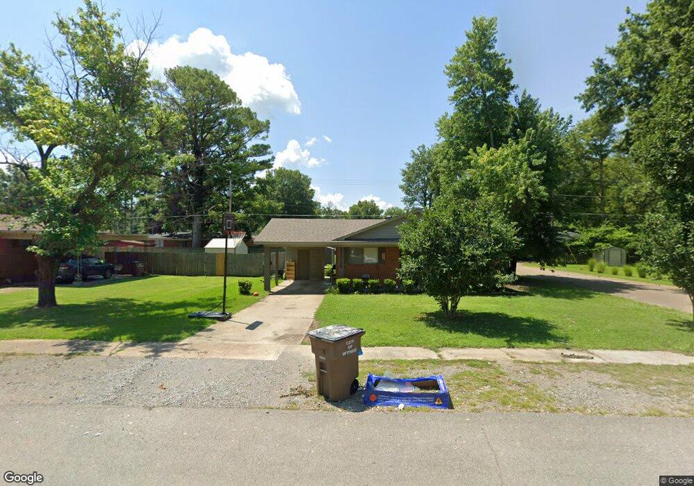
This home is located at 1205 Forrest Ave E, Wynne, AR 72396 and is currently estimated at $106,148, approximately $104 per square foot. 1205 Forrest Ave E is a home located in Cross County with nearby schools including Wynne Primary School, Wynne Intermediate School, and Wynne Junior High School.
Ownership History
Date
Name
Owned For
Owner Type
Purchase Details
Closed on
Jul 23, 2024
Sold by
Marcum Marsha E and Moise Marsha E
Bought by
Moise Keith D and Moise Marsha E
Current Estimated Value
Purchase Details
Closed on
May 19, 2008
Sold by
Revocab Catterton Ermal Eugene
Bought by
Marcum Gerry B and Marcum Marsha E
Purchase Details
Closed on
Mar 21, 1997
Bought by
Catterton, Fayrene Revoc. Trust
Purchase Details
Closed on
Mar 20, 1997
Bought by
Catterton Fayrene
Create a Home Valuation Report for This Property
The Home Valuation Report is an in-depth analysis detailing your home's value as well as a comparison with similar homes in the area
Purchase History
| Date | Buyer | Sale Price | Title Company |
|---|---|---|---|
| Moise Keith D | -- | None Listed On Document | |
| Marcum Gerry B | $35,000 | Cowling Title Company | |
| Catterton, Fayrene Revoc. Trust | -- | -- | |
| Catterton Fayrene | -- | -- |
Source: Public Records
Tax History
| Year | Tax Paid | Tax Assessment Tax Assessment Total Assessment is a certain percentage of the fair market value that is determined by local assessors to be the total taxable value of land and additions on the property. | Land | Improvement |
|---|---|---|---|---|
| 2025 | $658 | $19,260 | $2,610 | $16,650 |
| 2024 | $599 | $12,100 | $2,280 | $9,820 |
| 2023 | $599 | $12,100 | $2,280 | $9,820 |
| 2022 | $599 | $12,100 | $2,280 | $9,820 |
| 2021 | $599 | $12,100 | $2,280 | $9,820 |
| 2020 | $596 | $12,100 | $2,280 | $9,820 |
| 2019 | $542 | $10,950 | $2,070 | $8,880 |
| 2018 | $542 | $10,950 | $2,070 | $8,880 |
| 2017 | $542 | $10,950 | $2,070 | $8,880 |
| 2016 | $542 | $10,950 | $2,070 | $8,880 |
| 2015 | $542 | $10,950 | $2,070 | $8,880 |
| 2014 | $538 | $10,860 | $1,880 | $8,980 |
Source: Public Records
Map
Nearby Homes
- 1204 Forrest Ave E
- 1112 Poplar Ave E
- 226 Nathan Dr E
- 594 Malone St N
- 108 Nathan Dr E
- 1310 Forrest Ave E
- 1106 Marion Dr
- 109 Nathan Dr E
- 1104 Hamilton Ave E
- 621 Lemons St N
- 909 Killough Rd N
- 1420 Hamilton Ave E
- 1011 Hilltop Dr
- 802 Poplar Ave E
- 1201 Peterson Dr
- 1308 Killough Rd N
- 1621 Dodd Dr
- 39 Morningside Dr
- 8 Acres Arkansas 1
- 1009 Falls Blvd
- 1207 Forrest Ave E
- 1127 Forrest Ave E
- 1204 Poplar Ave E
- 1209 Forrest Ave E
- 1123 Forrest Ave E
- 1208 Poplar Ave E
- 309 Nathan Dr E
- 1206 Forrest Ave E
- 310 Nathan Dr E
- 1251 Forrest Ave E
- 1119 Forrest Ave E
- 1212 Poplar Ave E
- 1210 Forrest Ave E
- 305 Nathan Dr E
- 1110 Poplar Ave E
- 1120 Forrest Ave E
- 1115 Forrest Ave E
- 304 Nathan Dr E
- 1303 Forrest Ave E
- 1212 Forrest Ave E
Your Personal Tour Guide
Ask me questions while you tour the home.