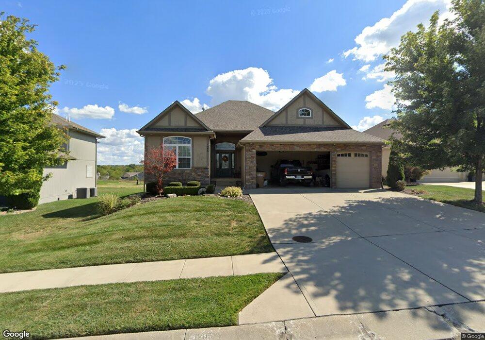
1205 Kingsland Cir Raymore, MO 64083
Estimated Value: $449,714 - $536,000
2
Beds
2
Baths
1,633
Sq Ft
$301/Sq Ft
Est. Value
About This Home
This home is located at 1205 Kingsland Cir, Raymore, MO 64083 and is currently estimated at $492,179, approximately $301 per square foot. 1205 Kingsland Cir is a home with nearby schools including Creekmoor Elementary School, Raymore-Peculiar East Middle School, and Raymore-Peculiar Senior High School.
Ownership History
Date
Name
Owned For
Owner Type
Purchase Details
Closed on
Jun 1, 2017
Sold by
Glatz Richard M and Glatz Lu Ann
Bought by
Glatz Richard M and The Richard M Glatz Intervivos Trust
Current Estimated Value
Purchase Details
Closed on
Sep 25, 2012
Sold by
Rose Riley L and Rose Linda L
Bought by
Glatz Lu A and Glatz Richard M
Purchase Details
Closed on
Oct 11, 2010
Sold by
Cooper Land Development Inc
Bought by
Rose Riley L and Rose Linda L
Create a Home Valuation Report for This Property
The Home Valuation Report is an in-depth analysis detailing your home's value as well as a comparison with similar homes in the area
Home Values in the Area
Average Home Value in this Area
Purchase History
| Date | Buyer | Sale Price | Title Company |
|---|---|---|---|
| Glatz Richard M | -- | None Available | |
| Glatz Lu A | -- | -- | |
| Rose Riley L | -- | -- |
Source: Public Records
Tax History
| Year | Tax Paid | Tax Assessment Tax Assessment Total Assessment is a certain percentage of the fair market value that is determined by local assessors to be the total taxable value of land and additions on the property. | Land | Improvement |
|---|---|---|---|---|
| 2025 | $4,866 | $66,600 | $12,190 | $54,410 |
| 2024 | $4,866 | $59,790 | $11,080 | $48,710 |
| 2023 | $4,859 | $59,790 | $11,080 | $48,710 |
| 2022 | $4,343 | $53,090 | $11,080 | $42,010 |
| 2021 | $4,344 | $53,090 | $11,080 | $42,010 |
| 2020 | $4,531 | $54,390 | $11,080 | $43,310 |
| 2019 | $4,374 | $54,390 | $11,080 | $43,310 |
| 2018 | $4,352 | $52,260 | $11,080 | $41,180 |
| 2017 | $4,022 | $52,260 | $11,080 | $41,180 |
| 2016 | $4,022 | $50,130 | $11,080 | $39,050 |
| 2015 | $4,024 | $50,130 | $11,080 | $39,050 |
| 2014 | $4,048 | $50,400 | $11,350 | $39,050 |
| 2013 | -- | $570 | $570 | $0 |
Source: Public Records
Map
Nearby Homes
- 1111 Hillswick Ln
- 512 Turnbridge Dr
- 809 Bridgeshire Dr
- 914 Rannoch Ln
- 707 Hampstead Dr
- 778 Creekmoor Dr
- 805 Glenn Cir
- 811 Glenn Cir
- 703 Hampstead Dr
- 1405 Kensington Ln
- 1205 Richards Cir
- 808 Glenn Cir
- 911 Zennor Ln
- 806 Glenn Cir
- 1201 Richards Cir
- 804 Glenn Cir
- 809 Glenn Cir
- 1624 Hanover Ln
- 1427 Young Cir
- 708 SW Glenn Cir
- 1203 Kingsland Cir
- 1207 Kingsland Cir
- 1208 Kingsland Cir
- 1201 Kingsland Cir
- 1206 Kingsland Cir
- 1207 Kettering Ln
- 1209 Kingsland Cir
- 1202 Kingsland Cir
- 1209 Kettering Ln
- 1204 Kingsland Cir
- 1211 Kingsland Cir
- 1208 Kettering Ln
- 1211 Kettering Ln
- 1124 Hillswick Ln
- 1126 Hillswick Ln
- 1122 Hillswick Ln
- 1213 Kingsland Cir
- 1213 Kettering Ln
- 1212 Kettering Ln
- 1216 Kingsland Cir
Your Personal Tour Guide
Ask me questions while you tour the home.