
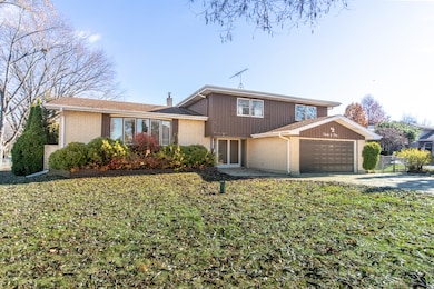
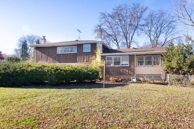
1205 Laurel Ln Schaumburg, IL 60193
South Schaumburg NeighborhoodEstimated payment $3,508/month
Highlights
- Recreation Room
- Workshop
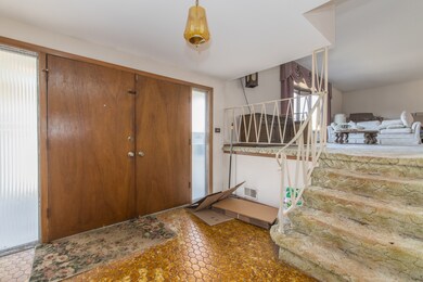
- Entrance Foyer
- Frederick Nerge Elementary School Rated A-
- Laundry Room
- Storage Room
About This Home
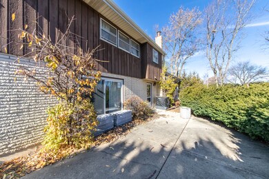
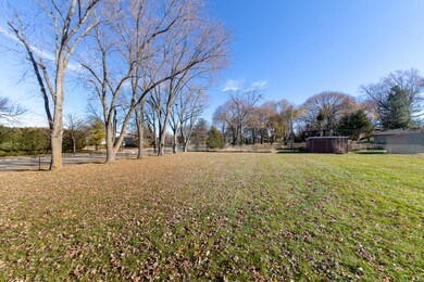
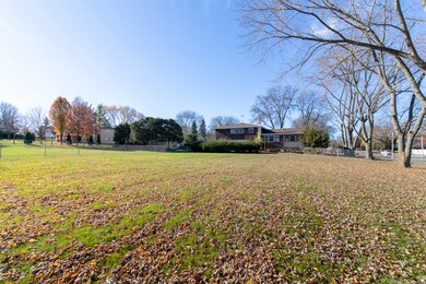
Attention rehabbers, investors and ambitious homeowners? This is the opportunity you've been waiting for- perfectly located in the heart of Schaumburg with convenient access to highways, top-rated schools, parks and shopping. This spacious home offers 4 generous bedrooms and 2.5 baths, providing a solid foundation for your creative vision. Enjoy a cozy family room with a wood-burning fireplace, plus a finished basement complete with storage and a workshop-ideal for transforming into your own personal "man cave" or hobby space. Situated on a half-acre, fully fenced lot, the property also features an extra-long, extra-wide driveway for ample parking. Please note: The estate is unable to clear out the home, so the buyer must be willing to remove remaining items- their loss may be your hidden treasure. Major updates include: Roof (complete tear-off) 10 years old - Furnace 3 years old - Dryer- 2018. The home is being sold "as is" but the potential is undeniable. The property ls vacant and easy to show- stop by anytime and envision the incredible possibilities. Your dream project starts here- don't miss it!
Home Details
Home Type
- Single Family
Est. Annual Taxes
- $11,773
Year Built
- Built in 1969
Lot Details
- Lot Dimensions are 100x200
Parking
- 2 Car Garage
Home Design
- Brick Exterior Construction
Interior Spaces
- 2,769 Sq Ft Home
- Multi-Level Property
- Wood Burning Fireplace
- Entrance Foyer
- Family Room with Fireplace
- Combination Dining and Living Room
- Recreation Room
- Workshop
- Storage Room
- Utility Room with Study Area
- Basement Fills Entire Space Under The House
Kitchen
- Range
- Microwave
- Dishwasher
Flooring
- Carpet
- Vinyl
Bedrooms and Bathrooms
- 4 Bedrooms
- 4 Potential Bedrooms
Laundry
- Laundry Room
- Dryer
- Washer
Schools
- Fredrick Nerge Elementary School
- Margaret Mead Junior High School
- J B Conant High School
Utilities
- Forced Air Heating and Cooling System
- Heating System Uses Natural Gas
- Shared Well
- Septic Tank
Listing and Financial Details
- Homeowner Tax Exemptions
Map
Home Values in the Area
Average Home Value in this Area
Tax History
| Year | Tax Paid | Tax Assessment Tax Assessment Total Assessment is a certain percentage of the fair market value that is determined by local assessors to be the total taxable value of land and additions on the property. | Land | Improvement |
|---|---|---|---|---|
| 2024 | $11,957 | $43,756 | $9,337 | $34,419 |
| 2023 | $11,566 | $46,000 | $9,337 | $36,663 |
| 2022 | $11,566 | $46,000 | $9,337 | $36,663 |
| 2021 | $10,139 | $36,782 | $26,260 | $10,522 |
| 2020 | $10,032 | $36,782 | $26,260 | $10,522 |
| 2019 | $5,009 | $40,869 | $26,260 | $14,609 |
| 2018 | $5,618 | $37,277 | $22,175 | $15,102 |
| 2017 | $5,433 | $37,277 | $22,175 | $15,102 |
| 2016 | $5,961 | $37,277 | $22,175 | $15,102 |
| 2015 | $6,782 | $34,471 | $18,674 | $15,797 |
| 2014 | $6,568 | $34,471 | $18,674 | $15,797 |
| 2013 | $6,551 | $34,471 | $18,674 | $15,797 |
Property History
| Date | Event | Price | List to Sale | Price per Sq Ft |
|---|---|---|---|---|
| 11/26/2025 11/26/25 | Pending | -- | -- | -- |
| 11/23/2025 11/23/25 | For Sale | $480,000 | -- | $173 / Sq Ft |
Purchase History
| Date | Type | Sale Price | Title Company |
|---|---|---|---|
| Interfamily Deed Transfer | -- | Attorney | |
| Interfamily Deed Transfer | -- | None Available | |
| Interfamily Deed Transfer | -- | -- |
Source: Midwest Real Estate Data (MRED)
MLS Number: 12519143
APN: 07-34-215-020-0000
Disclaimer: Certain information contained herein is derived from information provided by parties other than Homes.com. All information provided is deemed reliable, but is not guaranteed to be accurate and should be independently verified.
![]() Based on information submitted to the MLS GRID. All data is obtained from various sources and may not have been verified by broker or MLS GRID. Supplied Open House Information is subject to change without notice. All information should be independently reviewed and verified for accuracy. Properties may or may not be listed by the office/agent presenting the information. Some IDX listings have been excluded from this website.
Based on information submitted to the MLS GRID. All data is obtained from various sources and may not have been verified by broker or MLS GRID. Supplied Open House Information is subject to change without notice. All information should be independently reviewed and verified for accuracy. Properties may or may not be listed by the office/agent presenting the information. Some IDX listings have been excluded from this website.
The Digital Millennium Copyright Act of 1998, 17 U.S.C. § 512 (the “DMCA”) provides recourse for copyright owners who believe that material appearing on the Internet infringes their rights under U.S. copyright law. If you believe in good faith that any content or material made available in connection with our website or services infringes your copyright, you (or your agent) may send us a notice requesting that the content or material be removed, or access to it blocked.
Notices must be sent in writing by email to DMCAnotice@MLSGrid.com.
The DMCA requires that your notice of alleged copyright infringement include the following information:
(1) description of the copyrighted work that is the subject of claimed infringement;
(2) description of the alleged infringing content and information sufficient to permit us to locate the content;
(3) contact information for you, including your address, telephone number and email address;
(4) a statement by you that you have a good faith belief that the content in the manner complained of is not authorized by the copyright owner, or its agent, or by the operation of any law;
(5) a statement by you, signed under penalty of perjury, that the information in the notification is accurate and that you have the authority to enforce the copyrights that are claimed to be infringed; and
(6) a physical or electronic signature of the copyright owner or a person authorized to act on the copyright owner’s behalf. Failure to include all of the above information may result in the delay of the processing of your complaint.
- 124 E Monterey Ave
- 1323 S Roselle Rd
- 1420 Indian Hill Dr
- 1078 Newport Harbor Unit 6101
- 421 E Wise Rd
- 1100 Boston Harbor Unit 7004
- 1139 Rothbury Ct
- 211 Steeple Bush Ln Unit 10343
- 205 Steeple Bush Ln Unit 10444
- 1623 Indian Hill Dr
- 1531 Marion St
- 1630 Myrtle Park St
- 1630 Myrtle Park St
- 1630 Myrtle Park St
- 120 Pratt Blvd
- 1342 Lunt Ct Unit 56
- 717 Tipperary Ct Unit 1C
- 733 Limerick Ln Unit 7333D
- 727 Killarney Ct Unit 2D
- 357 Lucille Ln Unit 30
