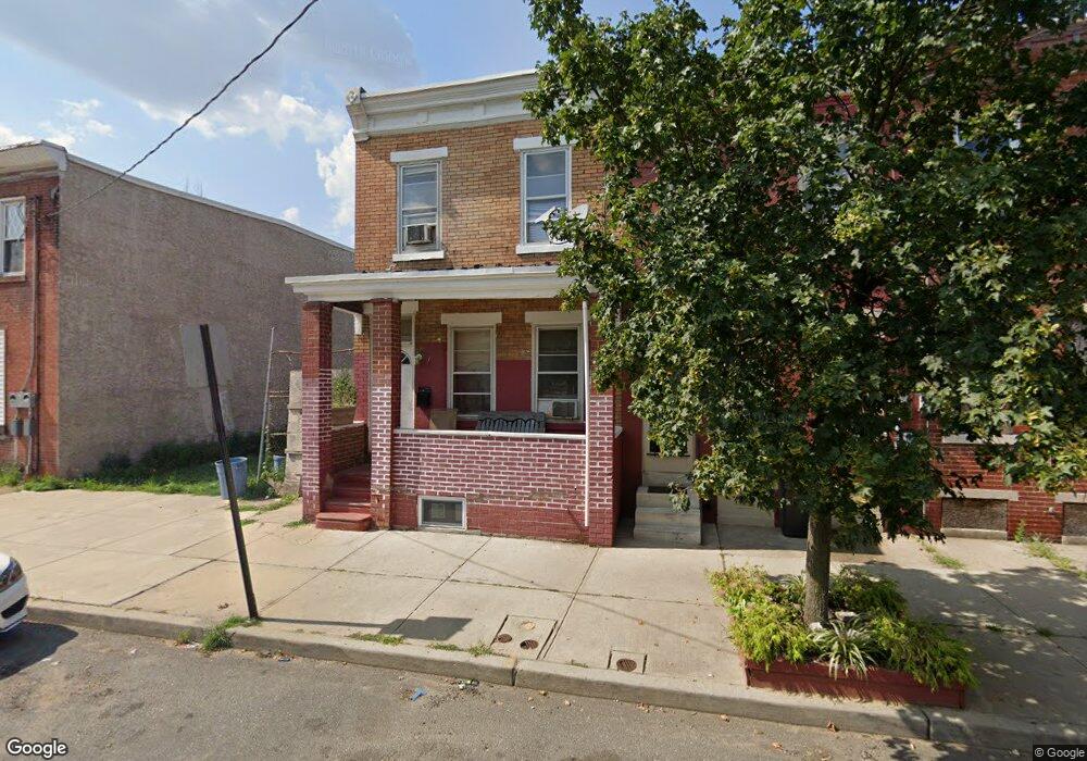
1205 Liberty St Camden, NJ 08104
Gateway NeighborhoodEstimated Value: $64,000 - $131,000
3
Beds
1
Bath
1,440
Sq Ft
$64/Sq Ft
Est. Value
About This Home
This home is located at 1205 Liberty St, Camden, NJ 08104 and is currently estimated at $91,582, approximately $63 per square foot. 1205 Liberty St is a home located in Camden County with nearby schools including Camden High School and Freedom Prep Charter School.
Ownership History
Date
Name
Owned For
Owner Type
Purchase Details
Closed on
Apr 22, 2016
Sold by
Bailey Toney
Bought by
Carter Lekeba S
Current Estimated Value
Purchase Details
Closed on
Oct 21, 2015
Sold by
Hardley Properties Llc
Bought by
Bailey Toney
Purchase Details
Closed on
Oct 7, 2014
Sold by
Bailey Toney
Bought by
Hardley Properties Llc
Purchase Details
Closed on
Nov 27, 2013
Sold by
Gibson Randy H
Bought by
Bailey Toney
Purchase Details
Closed on
Feb 11, 2011
Sold by
Bethea Sarah
Bought by
Gibson Randy
Purchase Details
Closed on
Sep 9, 2003
Sold by
Estate Of Frank R Balada
Bought by
Bethea Sarah and Gibson Randy
Create a Home Valuation Report for This Property
The Home Valuation Report is an in-depth analysis detailing your home's value as well as a comparison with similar homes in the area
Home Values in the Area
Average Home Value in this Area
Purchase History
| Date | Buyer | Sale Price | Title Company |
|---|---|---|---|
| Carter Lekeba S | -- | None Available | |
| Bailey Toney | -- | None Available | |
| Hardley Properties Llc | -- | None Available | |
| Bailey Toney | -- | None Available | |
| Gibson Randy | -- | -- | |
| Bethea Sarah | $1,000 | -- |
Source: Public Records
Tax History Compared to Growth
Tax History
| Year | Tax Paid | Tax Assessment Tax Assessment Total Assessment is a certain percentage of the fair market value that is determined by local assessors to be the total taxable value of land and additions on the property. | Land | Improvement |
|---|---|---|---|---|
| 2025 | $996 | $28,100 | $7,200 | $20,900 |
| 2024 | $962 | $28,100 | $7,200 | $20,900 |
| 2023 | $962 | $28,100 | $7,200 | $20,900 |
| 2022 | $944 | $28,100 | $7,200 | $20,900 |
| 2021 | $941 | $28,100 | $7,200 | $20,900 |
| 2020 | $894 | $28,100 | $7,200 | $20,900 |
| 2019 | $856 | $28,100 | $7,200 | $20,900 |
| 2018 | $851 | $28,100 | $7,200 | $20,900 |
| 2017 | $830 | $28,100 | $7,200 | $20,900 |
| 2016 | $804 | $28,100 | $7,200 | $20,900 |
| 2015 | $774 | $28,100 | $7,200 | $20,900 |
| 2014 | $755 | $28,100 | $7,200 | $20,900 |
Source: Public Records
Map
Nearby Homes
- 1169 Lansdowne Ave
- 1167 Lansdowne Ave
- 1165 Lansdowne Ave
- 1218 1/2 Atlantic Ave
- 1140 Kaighn Ave
- 1224 Chestnut St
- 1476 Mount Ephraim Ave Unit 3
- 1137 Sycamore St
- 1238 Haddon Ave
- 1275 Everett St
- 1327 Lansdowne Ave
- 1386 Haddon Ave
- 1249 Kenwood Ave
- 1261 Kenwood Ave
- 1361 Kaighns Ave
- 936 Mechanic St
- 1326 Princess Ave
- 1165 Morton St
- 1433 Haddon Ave
- 1268 Kenwood Ave
- 1207 Liberty St
- 1201 Liberty St
- 1209 Liberty St
- 1203 Liberty St
- 1211 Liberty St
- 1213 Liberty St
- 1215 Liberty St
- 1217 Liberty St
- 1206 Louis St
- 1217 1/2 Liberty St
- 1202 Louis St
- 1208 Liberty St
- 1219 Liberty St
- 1200 Louis St
- 1202 Liberty St
- 1221 Liberty St
- 1206 Liberty St
- 1212 Liberty St
- 1183 Liberty St
- 1214 Liberty St