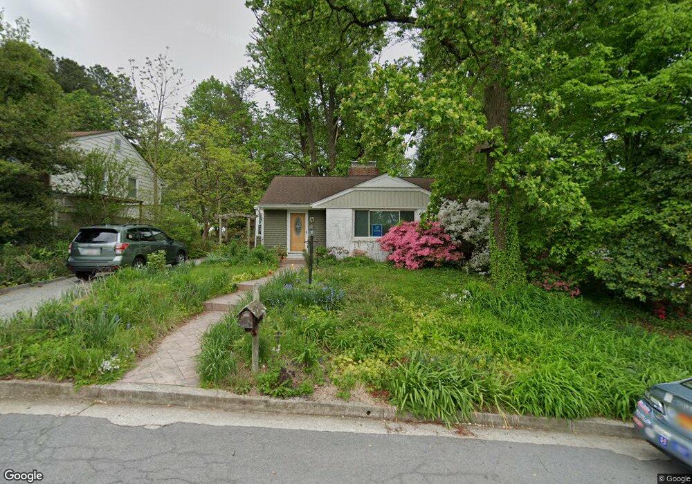
1205 Saint Andrews Way Baltimore, MD 21239
Estimated Value: $318,996 - $391,000
--
Bed
1
Bath
1,210
Sq Ft
$296/Sq Ft
Est. Value
About This Home
This home is located at 1205 Saint Andrews Way, Baltimore, MD 21239 and is currently estimated at $358,749, approximately $296 per square foot. 1205 Saint Andrews Way is a home located in Baltimore County with nearby schools including Halstead Academy, Loch Raven Technical Academy, and Towson High Law & Public Policy.
Ownership History
Date
Name
Owned For
Owner Type
Purchase Details
Closed on
Feb 14, 2024
Sold by
Riley Clark T and Riley Deborah S
Bought by
Riley Clark T and Riley Deborah S
Current Estimated Value
Purchase Details
Closed on
Sep 22, 2009
Sold by
Steele Riley Deborah
Bought by
Riley Deborah S and Riley Clark T
Purchase Details
Closed on
Jan 21, 2003
Sold by
Riley Clark Thomas
Bought by
Riley Deborah Steele
Purchase Details
Closed on
Jun 30, 1986
Sold by
Grzanna Reinhard
Bought by
Riley Clark Thomas
Create a Home Valuation Report for This Property
The Home Valuation Report is an in-depth analysis detailing your home's value as well as a comparison with similar homes in the area
Home Values in the Area
Average Home Value in this Area
Purchase History
| Date | Buyer | Sale Price | Title Company |
|---|---|---|---|
| Riley Clark T | -- | None Listed On Document | |
| Riley Clark T | -- | None Listed On Document | |
| Riley Deborah S | -- | -- | |
| Riley Deborah Steele | -- | -- | |
| Riley Clark Thomas | $94,000 | -- |
Source: Public Records
Tax History Compared to Growth
Tax History
| Year | Tax Paid | Tax Assessment Tax Assessment Total Assessment is a certain percentage of the fair market value that is determined by local assessors to be the total taxable value of land and additions on the property. | Land | Improvement |
|---|---|---|---|---|
| 2025 | $3,616 | $262,500 | $98,200 | $164,300 |
| 2024 | $3,616 | $247,667 | $0 | $0 |
| 2023 | $1,724 | $232,833 | $0 | $0 |
| 2022 | $3,197 | $218,000 | $87,100 | $130,900 |
| 2021 | $2,982 | $215,567 | $0 | $0 |
| 2020 | $2,982 | $213,133 | $0 | $0 |
| 2019 | $2,945 | $210,700 | $87,100 | $123,600 |
| 2018 | $2,897 | $208,400 | $0 | $0 |
| 2017 | $2,743 | $206,100 | $0 | $0 |
| 2016 | $2,392 | $203,800 | $0 | $0 |
| 2015 | $2,392 | $203,800 | $0 | $0 |
| 2014 | $2,392 | $203,800 | $0 | $0 |
Source: Public Records
Map
Nearby Homes
- 1204 Saint Andrews Way
- 6923 Summit Cir
- 6931 Summit Cir
- 1108 Litchfield Rd
- 6702 Queens Ferry Rd
- 12 Stone Ridge Ct
- 28 Stone Ridge Ct
- 908 Stevenson Ln
- 6415 Falkirk Rd
- 664 Regester Ave
- 1235 Walker Ave
- 6216 Falkirk Rd
- 1117 Walker Ave
- 1283 Gittings Ave
- 6204 Falkirk Rd
- 724 Overbrook Rd
- 701 Hillen Rd
- 6225 Chinquapin Pkwy
- 703 Hillen Rd
- 625 Yarmouth Rd
- 1203 Saint Andrews Way
- 1207 Saint Andrews Way
- 1207 Saint Andrews Way Unit BSMT
- 1207 St Andrews Way
- 1209 Saint Andrews Way
- 6706 Tweedbrook Rd
- 6708 Tweedbrook Rd
- 1201 Saint Andrews Way
- 1202 Saint Andrews Way
- 6747 Glenkirk Rd
- 1211 St Andrews Way
- 1211 Saint Andrews Way
- 1206 Saint Andrews Way
- 6710 Tweedbrook Rd
- 6745 Glenkirk Rd
- 6704 Tweedbrook Rd
- 6743 Glenkirk Rd
- 6741 Glenkirk Rd
- 6739 Glenkirk Rd
- 1200 Saint Andrews Way