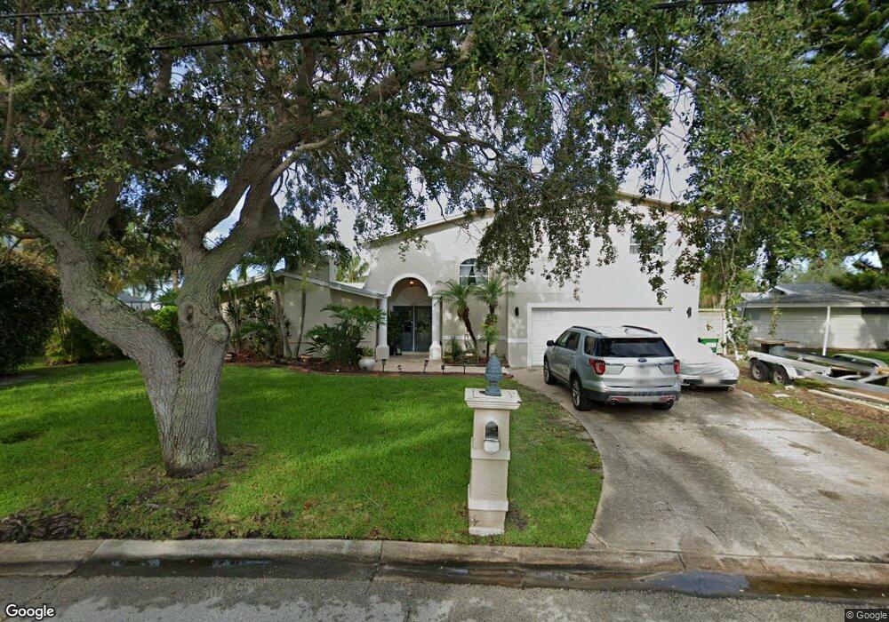
1205 Samar Rd Cocoa Beach, FL 32931
Estimated Value: $1,157,000 - $1,352,000
4
Beds
4
Baths
3,372
Sq Ft
$374/Sq Ft
Est. Value
About This Home
This home is located at 1205 Samar Rd, Cocoa Beach, FL 32931 and is currently estimated at $1,262,644, approximately $374 per square foot. 1205 Samar Rd is a home located in Brevard County with nearby schools including Theodore Roosevelt Elementary School, Cocoa Beach Junior/Senior High School, and Cocoa Beach Christian School.
Ownership History
Date
Name
Owned For
Owner Type
Purchase Details
Closed on
Aug 20, 1998
Sold by
Buchanan Cecelia M and Russell Buchanan J
Bought by
Buchanan J Russell
Current Estimated Value
Purchase Details
Closed on
Aug 31, 1995
Sold by
Vanburen Lorraine M
Bought by
Buchanan J Russell
Home Financials for this Owner
Home Financials are based on the most recent Mortgage that was taken out on this home.
Original Mortgage
$118,000
Interest Rate
7.58%
Create a Home Valuation Report for This Property
The Home Valuation Report is an in-depth analysis detailing your home's value as well as a comparison with similar homes in the area
Home Values in the Area
Average Home Value in this Area
Purchase History
| Date | Buyer | Sale Price | Title Company |
|---|---|---|---|
| Buchanan J Russell | -- | -- | |
| Buchanan J Russell | $168,000 | -- |
Source: Public Records
Mortgage History
| Date | Status | Borrower | Loan Amount |
|---|---|---|---|
| Previous Owner | Buchanan J Russell | $118,000 |
Source: Public Records
Tax History
| Year | Tax Paid | Tax Assessment Tax Assessment Total Assessment is a certain percentage of the fair market value that is determined by local assessors to be the total taxable value of land and additions on the property. | Land | Improvement |
|---|---|---|---|---|
| 2025 | $6,040 | $424,370 | -- | -- |
| 2024 | $5,926 | $410,410 | -- | -- |
| 2023 | $5,926 | $398,460 | $0 | $0 |
| 2022 | $5,248 | $370,070 | $0 | $0 |
| 2021 | $5,247 | $359,300 | $0 | $0 |
| 2020 | $5,208 | $354,340 | $0 | $0 |
| 2019 | $5,182 | $346,380 | $0 | $0 |
| 2018 | $5,200 | $342,040 | $0 | $0 |
| 2017 | $5,220 | $333,930 | $0 | $0 |
| 2016 | $5,209 | $327,070 | $240,000 | $87,070 |
| 2015 | $5,201 | $324,800 | $240,000 | $84,800 |
| 2014 | $5,222 | $322,230 | $215,000 | $107,230 |
Source: Public Records
Map
Nearby Homes
- 1034 Bali Rd
- 663 Bermuda Rd
- 1224 Samar Rd
- 1075 Samar Rd
- 135 Esther Dr
- 660 Java Rd
- 740 Java Rd
- 1044 Samar Rd
- 737 Nassau Rd
- 936 Santa Cruz Rd
- 926 Santa Cruz Rd
- 925 Samar Rd
- 159 Antigua Dr
- 272 Bahama Blvd
- 830 N Atlantic Ave Unit B1703
- 830 N Atlantic Ave Unit B1507
- 830 N Atlantic Ave Unit B908
- 830 N Atlantic Ave Unit B1002
- 830 N Atlantic Ave Unit B903
- 276 Curacau Dr
Your Personal Tour Guide
Ask me questions while you tour the home.