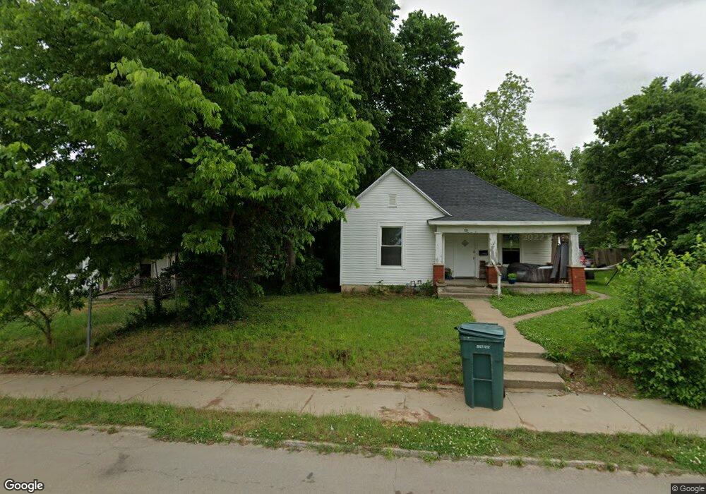
1205 W State Highway Ww Springfield, MO 65803
Estimated Value: $286,000 - $410,000
3
Beds
2
Baths
1,604
Sq Ft
$210/Sq Ft
Est. Value
About This Home
This home is located at 1205 W State Highway Ww, Springfield, MO 65803 and is currently estimated at $336,711, approximately $209 per square foot. 1205 W State Highway Ww is a home located in Greene County with nearby schools including Willard East Elementary School, Willard Intermediate School North, and Willard High School.
Ownership History
Date
Name
Owned For
Owner Type
Purchase Details
Closed on
Sep 9, 2016
Sold by
Lane Jeffrey W and Lane Yvette M
Bought by
Everhart John David
Current Estimated Value
Home Financials for this Owner
Home Financials are based on the most recent Mortgage that was taken out on this home.
Original Mortgage
$100,000
Outstanding Balance
$79,876
Interest Rate
3.43%
Mortgage Type
Commercial
Estimated Equity
$256,835
Create a Home Valuation Report for This Property
The Home Valuation Report is an in-depth analysis detailing your home's value as well as a comparison with similar homes in the area
Home Values in the Area
Average Home Value in this Area
Purchase History
| Date | Buyer | Sale Price | Title Company |
|---|---|---|---|
| Everhart John David | -- | None Available |
Source: Public Records
Mortgage History
| Date | Status | Borrower | Loan Amount |
|---|---|---|---|
| Open | Everhart John David | $100,000 |
Source: Public Records
Tax History Compared to Growth
Tax History
| Year | Tax Paid | Tax Assessment Tax Assessment Total Assessment is a certain percentage of the fair market value that is determined by local assessors to be the total taxable value of land and additions on the property. | Land | Improvement |
|---|---|---|---|---|
| 2025 | $1,364 | $27,730 | $9,200 | $18,530 |
| 2024 | $1,364 | $23,010 | $5,510 | $17,500 |
| 2023 | $1,360 | $23,010 | $5,510 | $17,500 |
| 2022 | $1,268 | $21,390 | $5,510 | $15,880 |
| 2021 | $1,214 | $21,390 | $5,510 | $15,880 |
| 2020 | $1,177 | $20,370 | $5,510 | $14,860 |
| 2019 | $1,171 | $20,370 | $5,510 | $14,860 |
| 2018 | $984 | $16,950 | $5,510 | $11,440 |
| 2017 | $977 | $16,950 | $5,510 | $11,440 |
| 2016 | $972 | $16,950 | $5,510 | $11,440 |
| 2015 | $966 | $16,950 | $5,510 | $11,440 |
| 2014 | $971 | $16,950 | $5,510 | $11,440 |
Source: Public Records
Map
Nearby Homes
- 2749 W Farm Road 56
- 000 W Pinewood Dr
- Tract 34 W Farm Road 76
- 000 Highway H
- 7208 N Farm Road 133
- 000 W Farm Road 76
- 1373 E River Oak Dr
- 6089 N Farm Road 159
- 2463 W Farm Road 76
- 1523 W Farm Road 40
- 3542 W Farm Road 60
- 000 W Farm Road 68
- 1487 E Lelia Ln
- 856 874 E Farm Road 80
- 9805 N Farm Road 149 County Rd
- 6487 N Farm Road 171
- 2172 E Farm Road 48
- 6054 N Farm Road 129
- 5382 N Lakewood Dr
- 555 E Farm 84 Rd
- 1125 W State Highway Ww
- 1265 W State Highway Ww
- 1092 W State Highway Ww
- 1350 W State Highway Ww
- 1309 W State Highway Ww
- 1309 W State Highway Ww
- 1070 W State Highway Ww
- 1330 W State Highway Ww
- 1006 W State Highway Ww
- 1450 W State Highway Ww
- Tract 2&3 State Highway Ww
- Tract 2 State Highway Ww
- Tract 1 State Highway Ww
- 0 State Highway Ww Unit 11011293
- 0 State Highway Ww Unit 11114023
- 0 State Highway Ww Unit 60066968
- 0 State Highway Ww Unit 60086279
- 1550 W State Highway Ww
- 863 W State Highway Ww
- 7618 N Farm Road 145