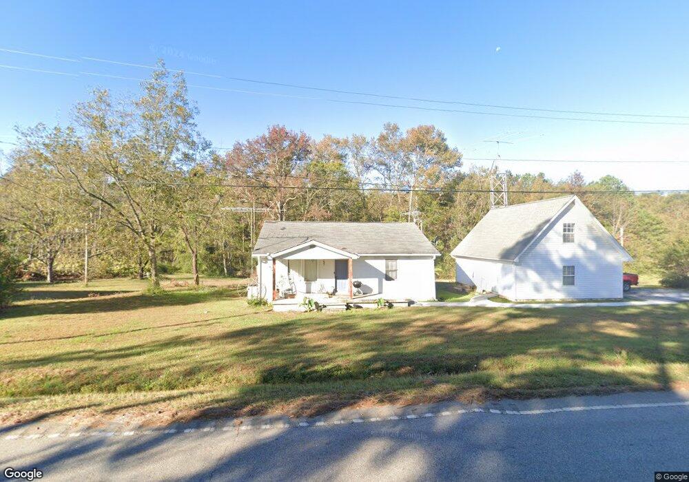
12050 Highway 56 Enoree, SC 29335
Estimated Value: $90,847 - $215,000
2
Beds
1
Bath
1,224
Sq Ft
$132/Sq Ft
Est. Value
About This Home
This home is located at 12050 Highway 56, Enoree, SC 29335 and is currently estimated at $161,712, approximately $132 per square foot. 12050 Highway 56 is a home with nearby schools including Woodruff Primary School, Woodruff Elementary School, and Woodruff Middle School.
Ownership History
Date
Name
Owned For
Owner Type
Purchase Details
Closed on
Aug 8, 2024
Sold by
Edwards Karen A and Edwards Karen
Bought by
Porter Noah and Porter Karrie
Current Estimated Value
Purchase Details
Closed on
Feb 14, 2022
Sold by
Glenn Kevin B
Bought by
Edwards Karen
Purchase Details
Closed on
Feb 9, 2022
Sold by
Whitmore Glenn Shirley
Bought by
Glenn Kevin B and Edwards Karen
Purchase Details
Closed on
Feb 8, 2022
Sold by
Harvey Glenn Jack
Bought by
Glenn Shirley W and Glenn Kevin
Create a Home Valuation Report for This Property
The Home Valuation Report is an in-depth analysis detailing your home's value as well as a comparison with similar homes in the area
Home Values in the Area
Average Home Value in this Area
Purchase History
| Date | Buyer | Sale Price | Title Company |
|---|---|---|---|
| Porter Noah | $68,000 | None Listed On Document | |
| Edwards Karen | -- | None Listed On Document | |
| Edwards Karen | -- | None Listed On Document | |
| Glenn Kevin B | -- | None Listed On Document | |
| Glenn Kevin B | -- | None Listed On Document | |
| Glenn Shirley W | -- | None Listed On Document | |
| Glenn Shirley W | -- | None Listed On Document |
Source: Public Records
Tax History Compared to Growth
Tax History
| Year | Tax Paid | Tax Assessment Tax Assessment Total Assessment is a certain percentage of the fair market value that is determined by local assessors to be the total taxable value of land and additions on the property. | Land | Improvement |
|---|---|---|---|---|
| 2025 | $844 | $4,672 | $1,080 | $3,592 |
| 2024 | $844 | $4,672 | $1,080 | $3,592 |
| 2023 | $844 | $5,544 | $810 | $4,734 |
| 2022 | $1,717 | $4,686 | $750 | $3,936 |
| 2021 | $146 | $2,616 | $419 | $2,197 |
| 2020 | $131 | $2,616 | $419 | $2,197 |
| 2019 | $133 | $2,616 | $419 | $2,197 |
| 2018 | $133 | $2,616 | $419 | $2,197 |
| 2017 | $68 | $2,092 | $363 | $1,729 |
| 2016 | $68 | $2,092 | $363 | $1,729 |
| 2015 | $63 | $2,092 | $363 | $1,729 |
| 2014 | $58 | $2,092 | $363 | $1,729 |
Source: Public Records
Map
Nearby Homes
- 2080 Browning Rd
- 490 Buncombe Rd
- 0 Sparkstown Dr
- 2100 Horseshoe Falls Rd
- 3465 Highway 92
- 3465 S Carolina 92
- Battlefield Rd
- 0 Cross Anchor Rd Unit 1552203
- 00 Ball Park Rd
- 1950 Ridge Rd
- 1220 Watson Rd Unit Enoree SC 29335
- 00 Mount Shoals Rd
- 1220 S 114
- 491 Adhurst Dr
- 491 Adhurst Dr Unit AA 60 Inlet B
- 717 Adhurst Dr
- 495 Adhurst Dr Unit AA 61 Davenport C
- 709 Adhurst Dr
- 495 Adhurst Dr
- 00 Frontier Rd
- 12020 Highway 56
- 12060 Highway 56
- 12025 Highway 56
- 12010 Highway 56
- 12001 Highway 56
- 12075 Highway 56
- 12080 Highway 56
- 12000 Highway 56
- 12090 Highway 56
- 11960 Highway 56
- 271 Burnt Factory Rd
- 0 Dillard Rd Unit 224788
- 00 Hwy 49 & Wildcat Rd
- 130 Post Ofc Rd
- 11905 S Carolina 56
- 120 Post Office Rd
- 651 Union Hwy
- 11850 Highway 56
- 11850 S Carolina 56
- 652 Union Hwy