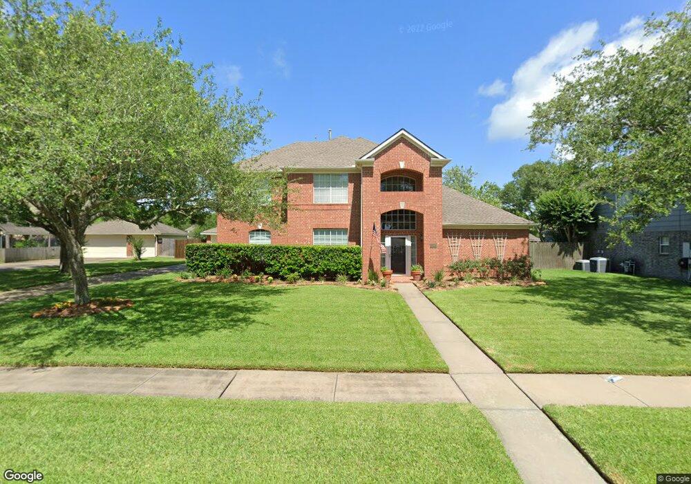
1206 Bob White Dr Friendswood, TX 77546
Estimated Value: $470,779 - $523,000
--
Bed
3
Baths
2,834
Sq Ft
$176/Sq Ft
Est. Value
About This Home
This home is located at 1206 Bob White Dr, Friendswood, TX 77546 and is currently estimated at $499,195, approximately $176 per square foot. 1206 Bob White Dr is a home located in Galveston County with nearby schools including C.W. Cline Elementary School, Windsong Elementary School, and Friendswood Junior High School.
Ownership History
Date
Name
Owned For
Owner Type
Purchase Details
Closed on
Sep 27, 2005
Sold by
Aamodt Arne E and Aamodt Kimberly B
Bought by
Beckman Dean A and Beckman Patricia M
Current Estimated Value
Home Financials for this Owner
Home Financials are based on the most recent Mortgage that was taken out on this home.
Original Mortgage
$190,400
Outstanding Balance
$101,911
Interest Rate
5.76%
Mortgage Type
Fannie Mae Freddie Mac
Estimated Equity
$397,284
Create a Home Valuation Report for This Property
The Home Valuation Report is an in-depth analysis detailing your home's value as well as a comparison with similar homes in the area
Home Values in the Area
Average Home Value in this Area
Purchase History
| Date | Buyer | Sale Price | Title Company |
|---|---|---|---|
| Beckman Dean A | -- | Chicago Title Friendswood |
Source: Public Records
Mortgage History
| Date | Status | Borrower | Loan Amount |
|---|---|---|---|
| Open | Beckman Dean A | $190,400 |
Source: Public Records
Tax History Compared to Growth
Tax History
| Year | Tax Paid | Tax Assessment Tax Assessment Total Assessment is a certain percentage of the fair market value that is determined by local assessors to be the total taxable value of land and additions on the property. | Land | Improvement |
|---|---|---|---|---|
| 2025 | $6,889 | $462,501 | $46,790 | $415,711 |
| 2024 | $6,889 | $435,910 | $46,790 | $389,120 |
| 2023 | $6,889 | $405,846 | $0 | $0 |
| 2022 | $8,126 | $368,951 | $0 | $0 |
| 2021 | $7,834 | $335,410 | $46,790 | $288,620 |
| 2020 | $8,064 | $334,710 | $46,790 | $287,920 |
| 2019 | $7,887 | $310,600 | $46,790 | $263,810 |
| 2018 | $7,299 | $310,600 | $46,790 | $263,810 |
| 2017 | $6,747 | $310,600 | $46,790 | $263,810 |
| 2016 | $6,133 | $280,000 | $46,790 | $233,210 |
| 2015 | $1,836 | $264,210 | $46,790 | $217,420 |
| 2014 | $1,836 | $177,440 | $46,790 | $130,650 |
Source: Public Records
Map
Nearby Homes
- 1906 Blue Quail Dr
- 1217 Red Wing Dr
- 1302 Eagle Lakes Dr
- 1802 Creekside Dr
- 1305 Edgewater Dr
- 1010 High Ridge Dr
- 1608 Keystone Dr
- 705 High Ridge Dr
- 2202 Calm Pond Ct
- 1804 Sandy Lake Dr
- 1606 Falcon Ridge Blvd
- 2120 Lila Sky Ln
- 1532 River Point Dr
- 1556 River Point Dr
- 111 Dunbar Unit 501
- 1531 Briar Bend Dr
- 506 Lakeside Ln
- 1572 River Point Dr
- 1568 River Point Dr
- 1588 River Point Dr
- 1204 Bob White Dr
- 1208 Bob White Dr
- 1205 Bob White Dr
- 1210 Bob White Dr
- 1202 Bob White Dr
- 1203 Bob White Dr
- 1207 Bob White Dr
- 1201 Bob White Dr
- 1205 Twin Oaks St
- 1209 Bob White Dr
- 1207 Twin Oaks St
- 1203 Twin Oaks St
- 1212 Bob White Dr
- 1209 Twin Oaks St
- 1206 Eagle Lakes Dr
- 1201 Twin Oaks St
- 1204 Eagle Lakes Dr
- 1208 Eagle Lakes Dr
- 1211 Bob White Dr
- 1112 Bob White Dr