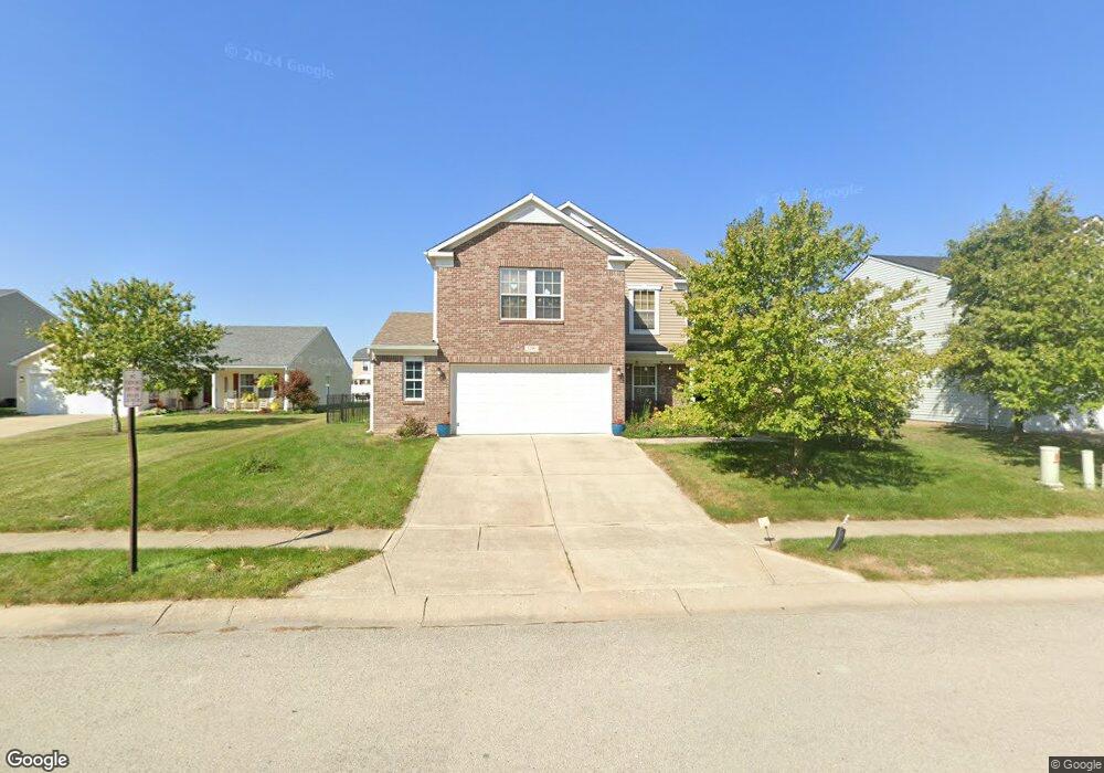
1206 Maple Run Dr Sheridan, IN 46069
Estimated Value: $318,000 - $345,494
3
Beds
3
Baths
2,613
Sq Ft
$126/Sq Ft
Est. Value
About This Home
This home is located at 1206 Maple Run Dr, Sheridan, IN 46069 and is currently estimated at $330,124, approximately $126 per square foot. 1206 Maple Run Dr is a home located in Hamilton County with nearby schools including Sheridan Elementary School, Sheridan Middle School, and Sheridan High School.
Ownership History
Date
Name
Owned For
Owner Type
Purchase Details
Closed on
Apr 27, 2009
Sold by
Swank Jeremy S and Phelps Swank Marcia E
Bought by
Belcher Jason D
Current Estimated Value
Home Financials for this Owner
Home Financials are based on the most recent Mortgage that was taken out on this home.
Original Mortgage
$114,880
Outstanding Balance
$71,878
Interest Rate
4.83%
Mortgage Type
FHA
Estimated Equity
$258,246
Purchase Details
Closed on
Mar 16, 2006
Sold by
C P Morgan Communities Lp
Bought by
Swank Jeremy S and Phelps Swank Marcia E
Home Financials for this Owner
Home Financials are based on the most recent Mortgage that was taken out on this home.
Original Mortgage
$127,712
Interest Rate
5.87%
Mortgage Type
Fannie Mae Freddie Mac
Create a Home Valuation Report for This Property
The Home Valuation Report is an in-depth analysis detailing your home's value as well as a comparison with similar homes in the area
Home Values in the Area
Average Home Value in this Area
Purchase History
| Date | Buyer | Sale Price | Title Company |
|---|---|---|---|
| Belcher Jason D | -- | Stewart Title | |
| Swank Jeremy S | -- | None Available |
Source: Public Records
Mortgage History
| Date | Status | Borrower | Loan Amount |
|---|---|---|---|
| Open | Belcher Jason D | $114,880 | |
| Previous Owner | Swank Jeremy S | $127,712 |
Source: Public Records
Tax History Compared to Growth
Tax History
| Year | Tax Paid | Tax Assessment Tax Assessment Total Assessment is a certain percentage of the fair market value that is determined by local assessors to be the total taxable value of land and additions on the property. | Land | Improvement |
|---|---|---|---|---|
| 2024 | $2,717 | $264,700 | $37,500 | $227,200 |
| 2023 | $2,752 | $242,500 | $37,500 | $205,000 |
| 2022 | $2,372 | $208,000 | $37,500 | $170,500 |
| 2021 | $2,208 | $193,900 | $37,500 | $156,400 |
| 2020 | $2,039 | $179,300 | $37,500 | $141,800 |
| 2019 | $1,948 | $171,500 | $18,300 | $153,200 |
| 2018 | $1,886 | $166,200 | $18,300 | $147,900 |
| 2017 | $1,682 | $148,600 | $18,300 | $130,300 |
| 2016 | $1,580 | $143,000 | $18,300 | $124,700 |
| 2014 | $1,518 | $140,600 | $32,000 | $108,600 |
| 2013 | $1,518 | $141,800 | $32,000 | $109,800 |
Source: Public Records
Map
Nearby Homes
- 1225 Maple Trace Way
- 1134 Maple Trace Way
- 413 Shadetree Ct
- 1224 Maple Trace Way
- 1300 Shadetree Ln
- 1102 Maple Run Dr
- 511 Tomahawk St
- 21650 Mule Barn Rd
- 907 S Ohio St
- 407 W 8th St
- 3936 W State Road 47
- Spruce Plan at Maple Run
- Chestnut Plan at Maple Run
- Juniper Plan at Maple Run
- Empress Plan at Maple Run
- Aspen II Plan at Maple Run
- Ironwood Plan at Maple Run
- Bradford Plan at Maple Run
- Walnut Plan at Maple Run
- Ashton Plan at Maple Run
- 1204 Maple Run Dr
- 1208 Maple Run Dr
- 1202 Maple Run Dr
- 1227 Maple Trace Way
- 1210 Maple Run Dr
- 1229 Maple Trace Way
- 1207 Maple Run Dr
- 1200 Maple Run Dr
- 1209 Maple Run Dr
- 1205 Maple Run Dr
- 1231 Maple Trace Way
- 1223 Maple Trace Way
- 1221 Maple Trace Way
- 1212 Maple Run Dr
- 1211 Maple Run Dr
- 1233 Maple Trace Way
- 1135 Maple Trace Way
- 1122 Maple Run Dr
- 1201 Maple Run Dr
- 1213 Maple Run Dr