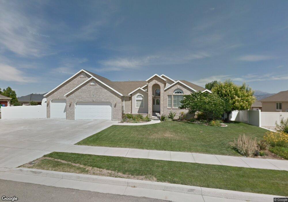
12061 S 4130 W Riverton, UT 84096
Estimated Value: $679,000 - $855,000
3
Beds
3
Baths
2,114
Sq Ft
$378/Sq Ft
Est. Value
About This Home
This home is located at 12061 S 4130 W, Riverton, UT 84096 and is currently estimated at $799,696, approximately $378 per square foot. 12061 S 4130 W is a home located in Salt Lake County with nearby schools including Midas Creek Elementary School, Oquirrh Hills Middle School, and Riverton High School.
Ownership History
Date
Name
Owned For
Owner Type
Purchase Details
Closed on
Feb 12, 2010
Sold by
Sorensen John M and Sorensen Valerie L
Bought by
Sorensen John and Sorensen Valerie
Current Estimated Value
Purchase Details
Closed on
Apr 25, 2000
Sold by
Kfp Corp
Bought by
Sorensen John M and Sorensen Valerie L
Home Financials for this Owner
Home Financials are based on the most recent Mortgage that was taken out on this home.
Original Mortgage
$241,047
Outstanding Balance
$83,874
Interest Rate
8.24%
Estimated Equity
$715,822
Create a Home Valuation Report for This Property
The Home Valuation Report is an in-depth analysis detailing your home's value as well as a comparison with similar homes in the area
Home Values in the Area
Average Home Value in this Area
Purchase History
| Date | Buyer | Sale Price | Title Company |
|---|---|---|---|
| Sorensen John | -- | None Available | |
| Sorensen John M | -- | Mt Olympus Title |
Source: Public Records
Mortgage History
| Date | Status | Borrower | Loan Amount |
|---|---|---|---|
| Open | Sorensen John M | $241,047 |
Source: Public Records
Tax History
| Year | Tax Paid | Tax Assessment Tax Assessment Total Assessment is a certain percentage of the fair market value that is determined by local assessors to be the total taxable value of land and additions on the property. | Land | Improvement |
|---|---|---|---|---|
| 2025 | $4,177 | $757,700 | $267,900 | $489,800 |
| 2024 | $4,177 | $723,000 | $255,600 | $467,400 |
| 2023 | $4,326 | $705,900 | $283,400 | $422,500 |
| 2022 | $4,507 | $721,400 | $277,900 | $443,500 |
| 2021 | $3,899 | $555,700 | $217,800 | $337,900 |
| 2020 | $3,557 | $472,600 | $217,800 | $254,800 |
| 2019 | $3,483 | $455,000 | $217,800 | $237,200 |
| 2017 | $3,401 | $426,300 | $189,300 | $237,000 |
| 2016 | $3,324 | $399,800 | $133,300 | $266,500 |
Source: Public Records
Map
Nearby Homes
- 4212 W Park Hollow Ln
- 4056 W Sullivan Rd
- 12307 S 3900 W
- 12666 S Glacier Trail Ln
- 12672 S Glacier Trail Ln
- 12692 S Glacier Trail Ln
- 12779 S Pinnacle Peak Ln Unit Lot G303
- 12674 S Lincoln Peak Ln Unit 111
- 12674 S Lincoln Peak Ln
- 12676 S Lincoln Peak Ln
- 12676 S Lincoln Peak Ln Unit 112
- 12682 S Lincoln Peak Ln
- 12686 S Lincoln Peak Ln
- 12688 S Lincoln Peak Ln
- 12688 S Lincoln Peak Ln Unit 115
- Lot # F303 12778 S Pinnacle Peak Ln
- Lot # F304 12778 S Pinnacle Peak Ln
- 4466 W 11800 S
- 4463 W Harvest Sun Ln
- 12406 S Mayan St
- 12077 S 4130 W
- 4083 W 12050 S
- 4079 W 12050 S
- 4118 W 12050 S
- 4137 W 12050 S
- 4098 W 12050 S
- 12044 S 4130 W
- 12093 S 4130 W
- 12098 Spring Wheat Cir
- 4063 W 12050 S
- 4076 W 12050 S
- 4076 W 12050 S Unit 104
- 12084 S 4130 W
- 12023 S 4130 W
- 4167 W 12050 S
- 12111 S 4130 W
- 12111 S 4130 W Unit 131
- 12116 Spring Wheat Cir
- 12116 S Spring Wheat Cir
- 12104 S 4130 W
Your Personal Tour Guide
Ask me questions while you tour the home.