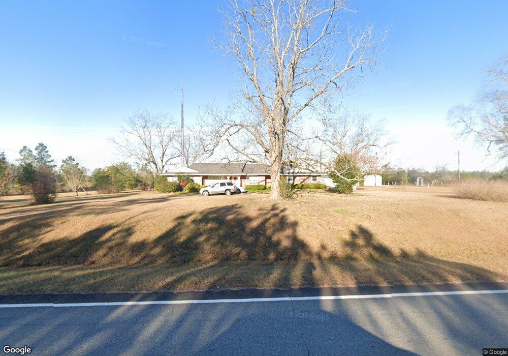
12069 Ga Highway 112 Irwinton, GA 31042
Estimated Value: $157,000 - $201,000
3
Beds
2
Baths
1,528
Sq Ft
$116/Sq Ft
Est. Value
About This Home
This home is located at 12069 Ga Highway 112, Irwinton, GA 31042 and is currently estimated at $176,602, approximately $115 per square foot. 12069 Ga Highway 112 is a home located in Wilkinson County with nearby schools including Wilkinson County Primary School, Wilkinson County Elementary School, and Wilkinson County Middle School.
Ownership History
Date
Name
Owned For
Owner Type
Purchase Details
Closed on
May 4, 2013
Sold by
Big Sandy Baptist Church
Bought by
Philpot Gaye W
Current Estimated Value
Purchase Details
Closed on
Feb 28, 2013
Sold by
Big Sandy Baptist Church
Bought by
Philpot Gaye W
Purchase Details
Closed on
Oct 24, 2007
Sold by
Big Sandy Baptist Church I
Bought by
Pierce Rava H
Purchase Details
Closed on
May 12, 2000
Sold by
Parker Marshall and Parker Cl
Bought by
Big Sandy Baptist Ch
Purchase Details
Closed on
May 16, 1997
Bought by
Parker Marshall and Parker Cl
Create a Home Valuation Report for This Property
The Home Valuation Report is an in-depth analysis detailing your home's value as well as a comparison with similar homes in the area
Home Values in the Area
Average Home Value in this Area
Purchase History
| Date | Buyer | Sale Price | Title Company |
|---|---|---|---|
| Philpot Gaye W | $62,900 | -- | |
| Philpot Gaye W | $62,860 | -- | |
| Pierce Rava H | -- | -- | |
| Big Sandy Baptist Ch | $84,000 | -- | |
| Parker Marshall | $83,000 | -- |
Source: Public Records
Tax History Compared to Growth
Tax History
| Year | Tax Paid | Tax Assessment Tax Assessment Total Assessment is a certain percentage of the fair market value that is determined by local assessors to be the total taxable value of land and additions on the property. | Land | Improvement |
|---|---|---|---|---|
| 2024 | $1,121 | $52,266 | $1,684 | $50,582 |
| 2023 | $311 | $26,959 | $1,954 | $25,005 |
| 2022 | $270 | $25,759 | $1,954 | $23,805 |
| 2021 | $271 | $25,759 | $1,954 | $23,805 |
| 2020 | $272 | $25,759 | $1,954 | $23,805 |
| 2019 | $272 | $25,759 | $1,954 | $23,805 |
| 2018 | $272 | $25,759 | $1,954 | $23,805 |
| 2017 | $827 | $25,759 | $1,954 | $23,805 |
| 2016 | $827 | $25,759 | $1,954 | $23,805 |
| 2015 | -- | $25,759 | $1,954 | $23,805 |
| 2014 | -- | $25,759 | $1,954 | $23,805 |
| 2013 | -- | $27,942 | $1,954 | $25,988 |
Source: Public Records
Map
Nearby Homes
- 2947 U S 441
- 242 Chappell Mill Rd
- 2203 Old MacOn Rd
- 00 Mount Olive Rd
- 103 Constitution Circle Dr Unit D
- 103 Constitution Circle Dr Unit B
- 103 Constitution Circle Dr Unit C
- 103 Constitution Circle Dr Unit A
- 00 Woodland Way
- 0 Woodland Way Unit 10491928
- 0 Mt Olive Unit 10469408
- 383 Evergreen Rd
- 0 Long Branch Rd Unit LOT 6
- 0 Long Branch Rd Unit LOT 5
- 0 Long Branch Rd Unit Lot 8
- 0 Long Branch Rd Unit 25649021
- 3148 Plantation Dr
- 3142 Plantation Dr
- 1924 Old Balls Ferry Rd
- 00 Old Balls Ferry Rd
- 12069 Georgia 112
- 12117 Ga Highway 112
- 11906 Ga Highway 112
- 2041 Us Highway 441 S
- 11665 Ga Highway 112
- 11611 Highway 112
- 2688 U S 441
- 2688 Us Highway 441 S
- 12443 Ga Highway 112
- 2685 Us Highway 441 S
- 2685 U S 441
- 1789 Us Highway 441 S
- 11611 Highway 112 Aka at Land Hwy
- 11611 Ga Highway 112
- 2895 Us Highway 441 S
- 2947 Us Highway 441 S
- 11482 Ga Highway 112
- 11482 Ga Highway 112
- 12575 Ga Highway 112
- 3061 U S 441