Estimated Value: $145,000 - $156,000
--
Bed
2
Baths
1,404
Sq Ft
$107/Sq Ft
Est. Value
About This Home
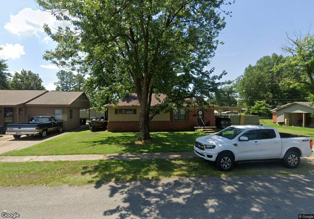
This home is located at 1207 Forrest Ave E, Wynne, AR 72396 and is currently estimated at $150,398, approximately $107 per square foot. 1207 Forrest Ave E is a home located in Cross County with nearby schools including Wynne Primary School, Wynne Intermediate School, and Wynne Junior High School.
Ownership History
Date
Name
Owned For
Owner Type
Purchase Details
Closed on
Sep 24, 2013
Sold by
Tarbutton John T and Tarbutton Barbara J
Bought by
Roland Joshua J and Roland Kristen
Current Estimated Value
Home Financials for this Owner
Home Financials are based on the most recent Mortgage that was taken out on this home.
Original Mortgage
$79,285
Outstanding Balance
$59,491
Interest Rate
4.54%
Mortgage Type
New Conventional
Estimated Equity
$90,907
Purchase Details
Closed on
Aug 30, 1994
Bought by
Tarbutton John T
Purchase Details
Closed on
Mar 1, 1989
Bought by
Tarbutton John
Create a Home Valuation Report for This Property
The Home Valuation Report is an in-depth analysis detailing your home's value as well as a comparison with similar homes in the area
Home Values in the Area
Average Home Value in this Area
Purchase History
| Date | Buyer | Sale Price | Title Company |
|---|---|---|---|
| Roland Joshua J | -- | -- | |
| Tarbutton John T | $22,700 | -- | |
| Tarbutton John | $28,000 | -- |
Source: Public Records
Mortgage History
| Date | Status | Borrower | Loan Amount |
|---|---|---|---|
| Open | Roland Joshua J | $79,285 |
Source: Public Records
Tax History Compared to Growth
Tax History
| Year | Tax Paid | Tax Assessment Tax Assessment Total Assessment is a certain percentage of the fair market value that is determined by local assessors to be the total taxable value of land and additions on the property. | Land | Improvement |
|---|---|---|---|---|
| 2024 | $354 | $17,290 | $3,860 | $13,430 |
| 2023 | $856 | $17,290 | $3,860 | $13,430 |
| 2022 | $856 | $17,290 | $3,860 | $13,430 |
| 2021 | $856 | $17,290 | $3,860 | $13,430 |
| 2020 | $450 | $17,290 | $3,860 | $13,430 |
| 2019 | $397 | $15,590 | $3,500 | $12,090 |
| 2018 | $422 | $15,590 | $3,500 | $12,090 |
| 2017 | $422 | $15,590 | $3,500 | $12,090 |
| 2016 | $422 | $15,590 | $3,500 | $12,090 |
| 2015 | $422 | $15,590 | $3,500 | $12,090 |
| 2014 | $772 | $15,600 | $3,190 | $12,410 |
Source: Public Records
Map
Nearby Homes
- 226 Nathan Dr E
- 594 Malone St N
- 568 Killough Rd N
- 108 Nathan Dr E
- 109 Nathan Dr E
- 2 Donegal Cir
- 1404 Airpark Rd
- 1008 Languille Ave E
- 1011 Hilltop Dr
- 6 A Londonderry Cir
- 1310 Bridges Ave E
- 1484 Hamilton Ave E
- 29 Sunset Dr
- 106 Eldridge Ct
- 1308 Killough Rd N
- 116 Bailey St S
- 35 Morningside Dr
- 919 Hamilton Ave E
- 810 Forrest Ave E
- 4 Briarcliff Cir
- 1205 Forrest Ave E
- 1209 Forrest Ave E
- 1208 Poplar Ave E
- 1204 Poplar Ave E
- 1251 Forrest Ave E
- 1127 Forrest Ave E
- 1206 Forrest Ave E
- 1204 Forrest Ave E
- 1212 Poplar Ave E
- 1210 Forrest Ave E
- 1123 Forrest Ave E
- 1112 Poplar Ave E
- 310 Nathan Dr E
- 1303 Forrest Ave E
- 309 Nathan Dr E
- 1212 Forrest Ave E
- 1314 Poplar Ave E
- 1119 Forrest Ave E
- 305 Nathan Dr E
- 1110 Poplar Ave E