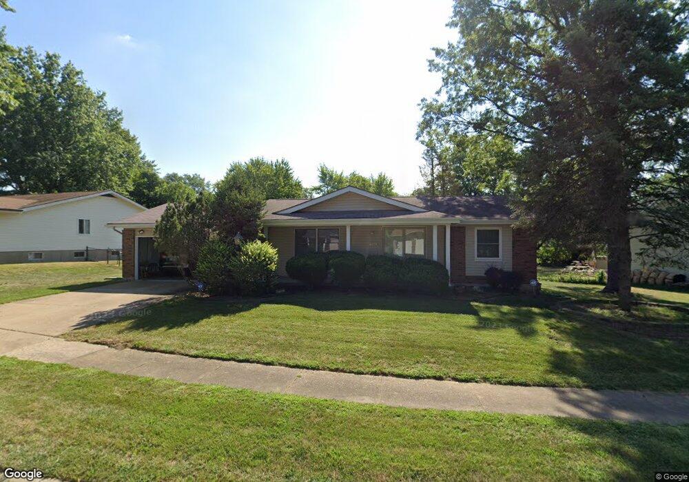
12070 Maidstone Ct Florissant, MO 63033
Estimated Value: $194,676 - $237,000
3
Beds
3
Baths
1,284
Sq Ft
$167/Sq Ft
Est. Value
About This Home
This home is located at 12070 Maidstone Ct, Florissant, MO 63033 and is currently estimated at $214,169, approximately $166 per square foot. 12070 Maidstone Ct is a home located in St. Louis County with nearby schools including Jamestown Elementary School, Central Middle School, and Hazelwood Central High School.
Ownership History
Date
Name
Owned For
Owner Type
Purchase Details
Closed on
Oct 31, 2017
Sold by
Batiste Rudolph Edward
Bought by
Batiste Rudolph Edward and Coleman Jennifer Marie
Current Estimated Value
Purchase Details
Closed on
Jun 21, 2006
Sold by
Coleman Batiste Janice and Coleman Janice
Bought by
Batiste Rudolph Edward and Coleman Batiste Janice
Purchase Details
Closed on
Jan 31, 1999
Sold by
Coleman Ronald E
Bought by
Coleman Janice
Create a Home Valuation Report for This Property
The Home Valuation Report is an in-depth analysis detailing your home's value as well as a comparison with similar homes in the area
Home Values in the Area
Average Home Value in this Area
Purchase History
| Date | Buyer | Sale Price | Title Company |
|---|---|---|---|
| Batiste Rudolph Edward | -- | None Available | |
| Batiste Rudolph Edward | -- | None Available | |
| Coleman Janice | -- | -- |
Source: Public Records
Tax History Compared to Growth
Tax History
| Year | Tax Paid | Tax Assessment Tax Assessment Total Assessment is a certain percentage of the fair market value that is determined by local assessors to be the total taxable value of land and additions on the property. | Land | Improvement |
|---|---|---|---|---|
| 2025 | $2,824 | $34,450 | $5,320 | $29,130 |
| 2024 | $2,824 | $31,240 | $3,690 | $27,550 |
| 2023 | $2,814 | $31,240 | $3,690 | $27,550 |
| 2022 | $2,677 | $26,430 | $6,120 | $20,310 |
| 2021 | $2,533 | $26,430 | $6,120 | $20,310 |
| 2020 | $2,463 | $23,940 | $5,360 | $18,580 |
| 2019 | $2,444 | $23,940 | $5,360 | $18,580 |
| 2018 | $2,334 | $21,130 | $2,320 | $18,810 |
| 2017 | $2,331 | $21,130 | $2,320 | $18,810 |
| 2016 | $2,338 | $20,850 | $3,080 | $17,770 |
| 2015 | $2,285 | $20,850 | $3,080 | $17,770 |
| 2014 | $2,082 | $18,890 | $4,660 | $14,230 |
Source: Public Records
Map
Nearby Homes
- 11951 Jerries Ln
- 5348 Trailoaks Dr
- 5432 Trailbend Dr
- 12292 Jerries Ln
- 5239 Trailoaks Dr
- 5372 Trailbend Dr
- 12095 El Camara Dr
- 12065 El Camara Dr
- 12455 Jerries Ln
- 12136 La Padera Ln
- 5226 Suntrail Dr
- 6250 Pennyrich Ct
- 12320 Missile Ln
- 11774 El Somo Ct
- 12582 Springtrail Dr
- 11922 La Padera Ln
- 6530 Farm Pond Ct
- 11760 Sheffield Dr
- 6480 Hadden Bay Dr
- 12991 Mourville Ct
- 12050 Maidstone Ct
- 12090 Maidstone Ct
- 12040 Maidstone Ct
- 12100 Maidstone Ct
- 12051 Jerries Ln
- 12031 Jerries Ln
- 12065 Maidstone Ct
- 12071 Jerries Ln
- 12095 Maidstone Ct
- 12055 Maidstone Ct
- 12085 Maidstone Ct
- 12075 Maidstone Ct
- 12011 Jerries Ln
- 12045 Maidstone Ct
- 12091 Jerries Ln
- 12020 Maidstone Ct
- 12105 Maidstone Ct
- 12035 Maidstone Ct
- 12110 Maidstone Ct
- 12101 Jerries Ln