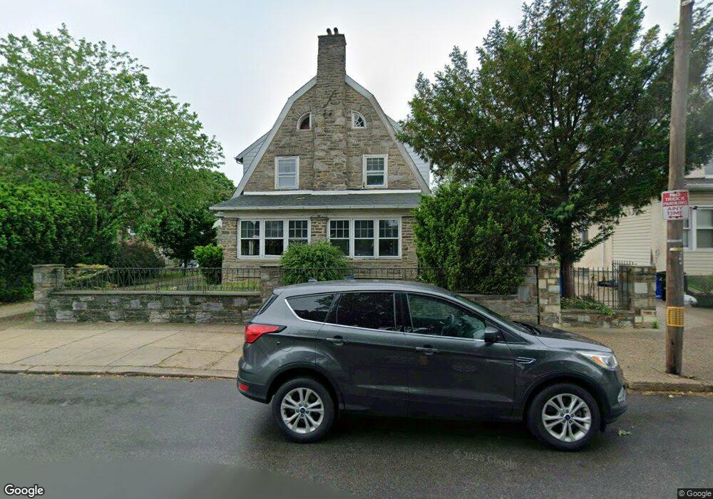
1208 Dyre St Philadelphia, PA 19124
Frankford NeighborhoodEstimated Value: $295,000 - $351,000
--
Bed
--
Bath
2,520
Sq Ft
$131/Sq Ft
Est. Value
About This Home
This home is located at 1208 Dyre St, Philadelphia, PA 19124 and is currently estimated at $330,896, approximately $131 per square foot. 1208 Dyre St is a home located in Philadelphia County with nearby schools including Frankford High School, The Philadelphia Charter School for the Arts & Sciences, and Frankford Friends School.
Ownership History
Date
Name
Owned For
Owner Type
Purchase Details
Closed on
Sep 19, 2017
Sold by
Wells Fargo Bank Na
Bought by
Moctezuma Luis Antonio and Abreu Alejandrina
Current Estimated Value
Purchase Details
Closed on
Nov 13, 2015
Sold by
Holmes Lois and Wells Fargo Bank Home Mortage
Bought by
Wells Fargo Bank Home Mortgage Inc and Norwest Mortgage Inc
Purchase Details
Closed on
May 22, 1998
Sold by
George Kenneth
Bought by
Holmes Alex and Holmes Lois
Purchase Details
Closed on
Oct 22, 1997
Sold by
Carter Allen G and Cormick Mary
Bought by
George Kenneth
Create a Home Valuation Report for This Property
The Home Valuation Report is an in-depth analysis detailing your home's value as well as a comparison with similar homes in the area
Home Values in the Area
Average Home Value in this Area
Purchase History
| Date | Buyer | Sale Price | Title Company |
|---|---|---|---|
| Moctezuma Luis Antonio | $122,500 | None Available | |
| Wells Fargo Bank Home Mortgage Inc | $100,000 | None Available | |
| Holmes Alex | $149,000 | -- | |
| George Kenneth | $98,900 | -- |
Source: Public Records
Tax History Compared to Growth
Tax History
| Year | Tax Paid | Tax Assessment Tax Assessment Total Assessment is a certain percentage of the fair market value that is determined by local assessors to be the total taxable value of land and additions on the property. | Land | Improvement |
|---|---|---|---|---|
| 2026 | $4,101 | $332,800 | $66,560 | $266,240 |
| 2025 | $4,101 | $332,800 | $66,560 | $266,240 |
| 2024 | $4,101 | $332,800 | $66,560 | $266,240 |
| 2023 | $4,101 | $293,000 | $58,600 | $234,400 |
| 2022 | $2,970 | $293,000 | $58,600 | $234,400 |
| 2021 | $2,970 | $0 | $0 | $0 |
| 2020 | $2,970 | $0 | $0 | $0 |
| 2019 | $2,962 | $0 | $0 | $0 |
| 2018 | $2,923 | $0 | $0 | $0 |
| 2017 | $2,923 | $0 | $0 | $0 |
| 2016 | $2,923 | $0 | $0 | $0 |
| 2015 | $2,798 | $0 | $0 | $0 |
| 2014 | -- | $208,800 | $94,622 | $114,178 |
| 2012 | -- | $35,200 | $6,957 | $28,243 |
Source: Public Records
Map
Nearby Homes
- 5050 Oxford Ave
- 1204 Dyre St
- 1213 Haworth St
- 1211 Haworth St
- 1209 Haworth St
- 1207 Haworth St
- 1215 Haworth St
- 1200 Dyre St
- 1205 Haworth St
- 1203 Haworth St
- 5100 Oxford Ave
- 1201 Haworth St
- 5030 Oxford Ave
- 1212 Haworth St
- 1210 Haworth St
- 5116 Oxford Ave
- 1216 Haworth St
- 1206 Haworth St
- 5111 Oxford Ave
- 5113 Oxford Ave