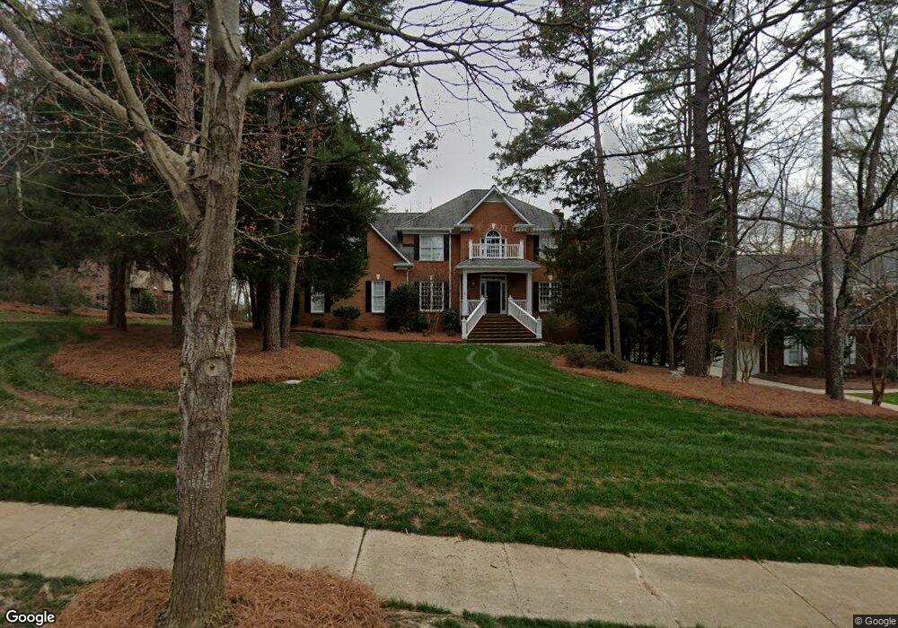
1208 Hudson Place Davidson, NC 28036
Estimated Value: $1,384,000 - $1,513,000
5
Beds
5
Baths
3,847
Sq Ft
$374/Sq Ft
Est. Value
About This Home
This home is located at 1208 Hudson Place, Davidson, NC 28036 and is currently estimated at $1,439,698, approximately $374 per square foot. 1208 Hudson Place is a home located in Mecklenburg County with nearby schools including Davidson Elementary School, William Amos Hough High School, and Davidson Green School.
Ownership History
Date
Name
Owned For
Owner Type
Purchase Details
Closed on
Nov 6, 2025
Sold by
Baker Michael H and Baker Amy G
Bought by
Cunningham Justin Daniel and Cunningham Emily Miller
Current Estimated Value
Home Financials for this Owner
Home Financials are based on the most recent Mortgage that was taken out on this home.
Original Mortgage
$1,200,000
Outstanding Balance
$1,200,000
Interest Rate
5.49%
Mortgage Type
New Conventional
Estimated Equity
$239,698
Purchase Details
Closed on
Mar 23, 2016
Sold by
Hooper Richard C and Hooper Barbara W
Bought by
Baker Micheal H and Baker Amy G
Home Financials for this Owner
Home Financials are based on the most recent Mortgage that was taken out on this home.
Original Mortgage
$417,000
Interest Rate
3.65%
Mortgage Type
New Conventional
Purchase Details
Closed on
Aug 23, 1994
Sold by
Agl Development L P % Alan G Dexter
Bought by
Hooper Richard C and Hooper Barbara W
Create a Home Valuation Report for This Property
The Home Valuation Report is an in-depth analysis detailing your home's value as well as a comparison with similar homes in the area
Home Values in the Area
Average Home Value in this Area
Purchase History
| Date | Buyer | Sale Price | Title Company |
|---|---|---|---|
| Cunningham Justin Daniel | $1,550,000 | Integrated Title | |
| Baker Micheal H | $580,000 | Chicago Title | |
| Hooper Richard C | $289,500 | -- |
Source: Public Records
Mortgage History
| Date | Status | Borrower | Loan Amount |
|---|---|---|---|
| Open | Cunningham Justin Daniel | $1,200,000 | |
| Previous Owner | Baker Micheal H | $417,000 |
Source: Public Records
Tax History
| Year | Tax Paid | Tax Assessment Tax Assessment Total Assessment is a certain percentage of the fair market value that is determined by local assessors to be the total taxable value of land and additions on the property. | Land | Improvement |
|---|---|---|---|---|
| 2025 | $7,397 | $980,900 | $500,000 | $480,900 |
| 2024 | $7,397 | $980,900 | $500,000 | $480,900 |
| 2023 | $7,397 | $980,900 | $500,000 | $480,900 |
| 2022 | $6,389 | $674,100 | $235,000 | $439,100 |
| 2021 | $6,354 | $674,100 | $235,000 | $439,100 |
| 2020 | $6,354 | $674,100 | $235,000 | $439,100 |
| 2019 | $6,348 | $674,100 | $235,000 | $439,100 |
| 2018 | $5,833 | $477,700 | $168,000 | $309,700 |
| 2017 | $5,794 | $477,700 | $168,000 | $309,700 |
| 2016 | $5,790 | $477,700 | $168,000 | $309,700 |
| 2015 | $5,787 | $477,700 | $168,000 | $309,700 |
| 2014 | $5,785 | $0 | $0 | $0 |
Source: Public Records
Map
Nearby Homes
- 316 Kimberly Rd
- 239 Kimberly Rd
- 1425 Samuel Spencer Pkwy Unit 5
- 606 Ardrey Cir
- 11916 Westbranch Pkwy
- 1400 Samuel Spencer Pkwy
- 1413 Samuel Spencer Pkwy Unit 3
- High Rock Plan at Davidson Woods
- Glenville Plan at Davidson Woods
- Hickory Plan at Davidson Woods
- 11826 Westbranch Pkwy
- 19149 Newburg Hill Rd
- 1418 Samuel Spencer Pkwy
- 1430 Samuel Spencer Pkwy Unit 13
- 19020 Newburg Hill Rd
- 19056 Newburg Hill Rd
- 866 Concord Rd
- 19110 Newburg Hill Rd
- 11634 Westbranch Pkwy
- 19048 Newburg Hill Rd
- 1200 Hudson Place
- 1216 Hudson Place
- 12241 Westbranch Pkwy
- 1224 Hudson Place
- 12231 Westbranch Pkwy Unit 1
- 325 Kimberly Rd
- 12247 Westbranch Pkwy
- 1217 Hudson Place
- 1300 Hudson Place
- 315 Kimberly Rd
- 324 Kimberly Rd
- 12253 Westbranch Pkwy Unit 4
- 1227 Hudson Place
- 12222 Westbranch Pkwy Unit 70
- 12303 Westbranch Pkwy Unit 5
- 902 Claires Creek Ln
- 307 Kimberly Rd
- 1310 Hudson Place
- 1305 Hudson Place
- 1109 Hudson Place
Your Personal Tour Guide
Ask me questions while you tour the home.