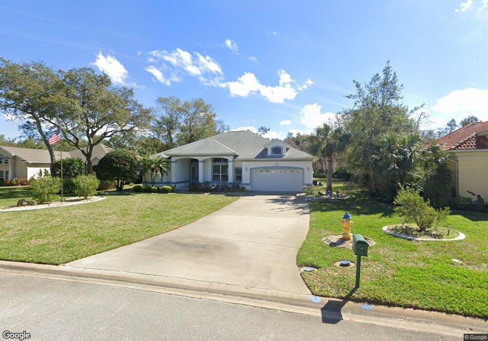
1208 Londonderry Cir Ormond Beach, FL 32174
Halifax Plantation NeighborhoodEstimated Value: $480,000 - $581,000
3
Beds
2
Baths
2,230
Sq Ft
$238/Sq Ft
Est. Value
About This Home
This home is located at 1208 Londonderry Cir, Ormond Beach, FL 32174 and is currently estimated at $531,430, approximately $238 per square foot. 1208 Londonderry Cir is a home located in Volusia County with nearby schools including Pine Trail Elementary School, Ormond Beach Middle School, and Seabreeze High School.
Ownership History
Date
Name
Owned For
Owner Type
Purchase Details
Closed on
Jul 10, 2023
Sold by
Ludlow Janet L
Bought by
Ludlow Janet L and Ludlow Robert E
Current Estimated Value
Purchase Details
Closed on
Nov 13, 1998
Sold by
Halifax Plantation Inc
Bought by
Ludlow Robert E and Ludlow Janet L
Home Financials for this Owner
Home Financials are based on the most recent Mortgage that was taken out on this home.
Original Mortgage
$30,000
Interest Rate
6.47%
Create a Home Valuation Report for This Property
The Home Valuation Report is an in-depth analysis detailing your home's value as well as a comparison with similar homes in the area
Home Values in the Area
Average Home Value in this Area
Purchase History
| Date | Buyer | Sale Price | Title Company |
|---|---|---|---|
| Ludlow Janet L | $100 | None Listed On Document | |
| Ludlow Robert E | $41,000 | -- |
Source: Public Records
Mortgage History
| Date | Status | Borrower | Loan Amount |
|---|---|---|---|
| Previous Owner | Ludlow Robert E | $30,000 |
Source: Public Records
Tax History
| Year | Tax Paid | Tax Assessment Tax Assessment Total Assessment is a certain percentage of the fair market value that is determined by local assessors to be the total taxable value of land and additions on the property. | Land | Improvement |
|---|---|---|---|---|
| 2026 | $328 | $328,708 | -- | -- |
| 2025 | $328 | $320,067 | -- | -- |
| 2024 | $304 | $311,047 | -- | -- |
| 2023 | $304 | $301,988 | $0 | $0 |
| 2022 | $285 | $293,192 | $0 | $0 |
| 2021 | $285 | $284,652 | $0 | $0 |
| 2020 | $278 | $280,722 | $42,900 | $237,822 |
| 2019 | $278 | $283,294 | $45,100 | $238,194 |
| 2018 | $261 | $284,370 | $53,900 | $230,470 |
| 2017 | $3,722 | $209,450 | $0 | $0 |
| 2016 | $3,781 | $205,142 | $0 | $0 |
| 2015 | $3,879 | $203,716 | $0 | $0 |
| 2014 | $3,759 | $202,099 | $0 | $0 |
Source: Public Records
Map
Nearby Homes
- 3639 Mallow Dr
- 1333 Antrim Cir
- 1128 Killarney Dr
- 3751 Carrick Dr
- 3763 Carrick Dr
- 1176 Athlone Way
- 3709 Donegal Cir
- 1111 Athlone Way
- 1405 Newry Cir
- 1309 Wicklow Ln
- 3330 Bailey Ann Dr
- 3735 Roscommon Dr
- 3356 Newbliss Cir
- 3404 Rexford Cir
- 3908 Tano Dr
- 1313 Runaby Ln
- 3169 Connemara Dr
- 3324 Westmeath Dr
- 3145 Connemara Dr
- 3132 Connemara Dr
- 1204 Londonderry Cir
- 1212 Londonderry Cir
- 1216 Londonderry Cir
- 1200 Londonderry Cir
- 1209 Londonderry Cir Unit II
- 1213 Londonderry Cir
- 1205 Londonderry Cir
- 1220 Londonderry Cir
- 3640 Aran Cir
- 3644 Galway Ln
- 3636 Aran Cir
- 3648 Galway Ln
- 1201 Londonderry Cir
- 1217 Londonderry Cir
- 1316 Antrim Cir
- 1224 Londonderry Cir
- 1320 Antrim Cir
- 1312 Antrim Cir
- 1236 Killarney Dr
- 1324 Antrim Cir
Your Personal Tour Guide
Ask me questions while you tour the home.