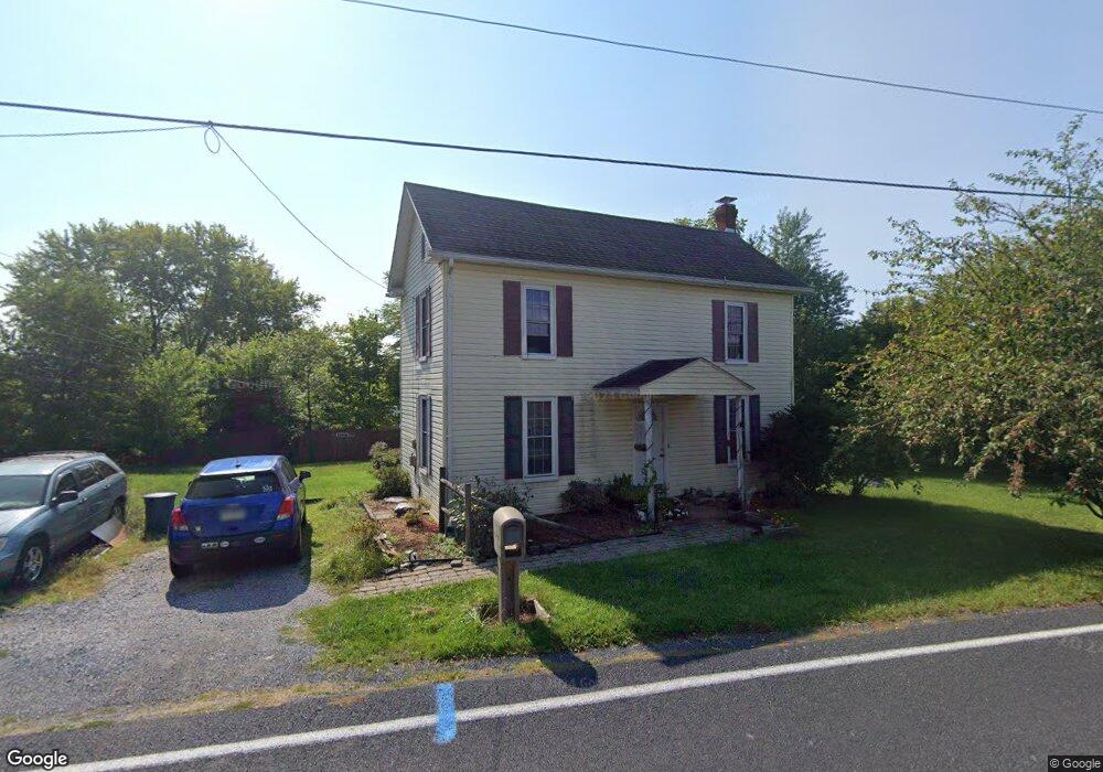
12080 Polktown Rd Waynesboro, PA 17268
Estimated Value: $175,781 - $346,000
3
Beds
2
Baths
1,884
Sq Ft
$137/Sq Ft
Est. Value
About This Home
This home is located at 12080 Polktown Rd, Waynesboro, PA 17268 and is currently estimated at $257,195, approximately $136 per square foot. 12080 Polktown Rd is a home located in Franklin County with nearby schools including Waynesboro Area Senior High School, St. Andrew Catholic School, and Noah's Ark Christian Child Care Center.
Ownership History
Date
Name
Owned For
Owner Type
Purchase Details
Closed on
Jan 14, 2011
Sold by
Rae Todd Anthony W and Rae Todd Gwendolynn
Bought by
Landon Ronald S
Current Estimated Value
Home Financials for this Owner
Home Financials are based on the most recent Mortgage that was taken out on this home.
Original Mortgage
$87,620
Outstanding Balance
$58,202
Interest Rate
4.25%
Mortgage Type
FHA
Estimated Equity
$198,993
Purchase Details
Closed on
Feb 29, 2008
Sold by
Tumminello Charles E and Tunninello Melanie H
Bought by
Musolino David S and Musolino Bridget M
Purchase Details
Closed on
Feb 9, 2007
Sold by
Todd Anthony W and Todd Rose M
Bought by
Todd Anthony W
Home Financials for this Owner
Home Financials are based on the most recent Mortgage that was taken out on this home.
Original Mortgage
$166,000
Interest Rate
6.23%
Mortgage Type
Unknown
Create a Home Valuation Report for This Property
The Home Valuation Report is an in-depth analysis detailing your home's value as well as a comparison with similar homes in the area
Home Values in the Area
Average Home Value in this Area
Purchase History
| Date | Buyer | Sale Price | Title Company |
|---|---|---|---|
| Landon Ronald S | $89,900 | None Available | |
| Musolino David S | $220,000 | None Available | |
| Todd Anthony W | -- | None Available |
Source: Public Records
Mortgage History
| Date | Status | Borrower | Loan Amount |
|---|---|---|---|
| Open | Landon Ronald S | $87,620 | |
| Previous Owner | Todd Anthony W | $166,000 |
Source: Public Records
Tax History Compared to Growth
Tax History
| Year | Tax Paid | Tax Assessment Tax Assessment Total Assessment is a certain percentage of the fair market value that is determined by local assessors to be the total taxable value of land and additions on the property. | Land | Improvement |
|---|---|---|---|---|
| 2025 | $2,326 | $15,140 | $1,500 | $13,640 |
| 2024 | $2,258 | $15,140 | $1,500 | $13,640 |
| 2023 | $2,191 | $15,140 | $1,500 | $13,640 |
| 2022 | $2,126 | $15,140 | $1,500 | $13,640 |
| 2021 | $2,065 | $15,140 | $1,500 | $13,640 |
| 2020 | $2,034 | $15,140 | $1,500 | $13,640 |
| 2019 | $1,988 | $15,140 | $1,500 | $13,640 |
| 2018 | $1,924 | $15,140 | $1,500 | $13,640 |
| 2017 | $1,303 | $10,480 | $1,500 | $8,980 |
| 2016 | $300 | $10,480 | $1,500 | $8,980 |
| 2015 | $280 | $10,480 | $1,500 | $8,980 |
| 2014 | $280 | $10,480 | $1,500 | $8,980 |
Source: Public Records
Map
Nearby Homes
- 4798 Gray Hawk Dr Unit 17
- 12152 Red Hawk Dr
- 5377 Harrier Way
- 5385 Harrier Way
- TBD Whippet Trail
- TBD Harrier Way
- 12041 Koons Rd
- 4594 Salem Church Rd
- 6287 Marsh Rd
- 6668 Marsh Rd
- 607 Chicory Spring Ct
- 462 Scott Ave Unit 4
- 417 Fairview Ave
- 105 Fairview Ave
- 0 Westview Ave
- 220 Cleveland Ave
- 511 Hamilton Ave
- 130 Hamilton Ave
- 208 Hamilton Ave
- 12068 Polktown Rd
- 12101 Polktown Rd
- 12222 Polktown Rd
- 12117 Polktown Rd
- 12133 Polktown Rd
- 12184 Polktown Rd
- 12106 Sky Hawk Dr
- 12034 Polktown Rd
- 12106 Skyhawk Dr
- 12114 Skyhawk Dr
- 12114 Sky Hawk Dr
- 12090 Skyhawk Dr
- 12130 Sky Hawk Dr
- 12090 Sky Hawk Dr
- 12130 Skyhawk Dr
- 12222 Polktown Rd
- 12138 Sky Hawk Dr
- 12224 Polktown Rd
- 4837 Gray Hawk Dr
- 4880 Buchanan Trail E