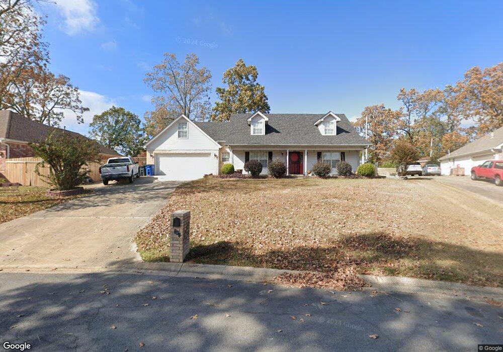
1209 Kierre Loop North Little Rock, AR 72116
Amboy NeighborhoodEstimated Value: $251,397 - $292,000
--
Bed
4
Baths
1,878
Sq Ft
$143/Sq Ft
Est. Value
About This Home
This home is located at 1209 Kierre Loop, North Little Rock, AR 72116 and is currently estimated at $268,099, approximately $142 per square foot. 1209 Kierre Loop is a home located in Pulaski County with nearby schools including Indian Hills Elementary School, North Little Rock Middle School 6th Grade Campus, and North Little Rock High School.
Ownership History
Date
Name
Owned For
Owner Type
Purchase Details
Closed on
May 28, 1998
Sold by
Brown J B and Brown Laura A
Bought by
Banks Marcas E and Banks Alice R
Current Estimated Value
Home Financials for this Owner
Home Financials are based on the most recent Mortgage that was taken out on this home.
Original Mortgage
$139,150
Interest Rate
6.9%
Mortgage Type
Purchase Money Mortgage
Create a Home Valuation Report for This Property
The Home Valuation Report is an in-depth analysis detailing your home's value as well as a comparison with similar homes in the area
Home Values in the Area
Average Home Value in this Area
Purchase History
| Date | Buyer | Sale Price | Title Company |
|---|---|---|---|
| Banks Marcas E | $147,000 | Lenders Title Company |
Source: Public Records
Mortgage History
| Date | Status | Borrower | Loan Amount |
|---|---|---|---|
| Previous Owner | Banks Marcas E | $139,150 |
Source: Public Records
Tax History Compared to Growth
Tax History
| Year | Tax Paid | Tax Assessment Tax Assessment Total Assessment is a certain percentage of the fair market value that is determined by local assessors to be the total taxable value of land and additions on the property. | Land | Improvement |
|---|---|---|---|---|
| 2025 | $2,723 | $40,760 | $8,400 | $32,360 |
| 2024 | $2,596 | $40,760 | $8,400 | $32,360 |
| 2023 | $2,596 | $40,760 | $8,400 | $32,360 |
| 2022 | $2,478 | $40,760 | $8,400 | $32,360 |
| 2021 | $2,359 | $35,320 | $8,300 | $27,020 |
| 2020 | $1,984 | $35,320 | $8,300 | $27,020 |
| 2019 | $1,984 | $35,320 | $8,300 | $27,020 |
| 2018 | $2,009 | $35,320 | $8,300 | $27,020 |
| 2017 | $2,009 | $35,320 | $8,300 | $27,020 |
| 2016 | $2,170 | $37,730 | $7,820 | $29,910 |
| 2015 | $2,520 | $37,730 | $7,820 | $29,910 |
| 2014 | $2,520 | $37,730 | $7,820 | $29,910 |
Source: Public Records
Map
Nearby Homes
- 1115 Claycut Cir
- 6324 Allwood Dr
- 1010 Claycut Cir
- 6312 Allwood Dr
- 6312 Rolling Hills Dr
- 6317 Rolling Hills Dr
- 1209 Silverwood Trail
- 126 Cobblestone Cir
- 813 Silver Hill Rd
- 1204 N Point Ln
- 7 Edenwood Ln
- 47 Perin Rd
- 10 Silverwood Ct
- 5 Edenwood Ln
- 13 Stanwood Loop
- 7100 Sequoyah Ln
- 5809 N Locust St
- 1218 Mission Rd
- 8 Minnehaha Ct
- 5709 N Cedar St
- 1205 Kierre Loop
- 1213 Kierre Loop
- 1204 Kierre Loop
- 1201 Kierre Loop
- 1217 Kierre Loop
- 1001 Kierre Dr
- 1208 Kierre Loop
- 1221 Kierre Loop
- 1022 Claycut Cir
- 1005 Kierre Dr
- 1018 Claycut Cir
- 1106 Claycut Cir
- 1212 Kierre Loop
- 1110 Claycut Cir
- 1110 Claycut Cir
- 1225 Kierre Loop
- 1009 Kierre Dr
- 918 Kierre Dr
- 922 Kierre Dr
- 1014 Claycut Cir