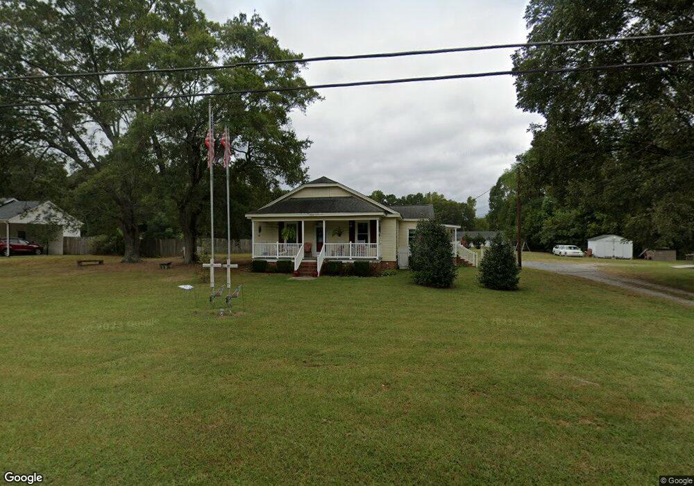
1209 Neal Hawkins Rd Gastonia, NC 28056
Estimated Value: $278,000 - $339,000
3
Beds
2
Baths
1,762
Sq Ft
$175/Sq Ft
Est. Value
About This Home
This home is located at 1209 Neal Hawkins Rd, Gastonia, NC 28056 and is currently estimated at $308,106, approximately $174 per square foot. 1209 Neal Hawkins Rd is a home with nearby schools including Robinson Elementary School, Southwest Middle School, and Forestview High School.
Ownership History
Date
Name
Owned For
Owner Type
Purchase Details
Closed on
Oct 20, 2006
Sold by
Brandon Harry Neil and Carole Brandon E
Bought by
Brandon Harry Neil and Brandon Elizabeth Carole
Current Estimated Value
Home Financials for this Owner
Home Financials are based on the most recent Mortgage that was taken out on this home.
Original Mortgage
$85,500
Interest Rate
6.45%
Mortgage Type
Purchase Money Mortgage
Create a Home Valuation Report for This Property
The Home Valuation Report is an in-depth analysis detailing your home's value as well as a comparison with similar homes in the area
Home Values in the Area
Average Home Value in this Area
Purchase History
| Date | Buyer | Sale Price | Title Company |
|---|---|---|---|
| Brandon Harry Neil | $90,000 | None Available |
Source: Public Records
Mortgage History
| Date | Status | Borrower | Loan Amount |
|---|---|---|---|
| Closed | Brandon Harry Neil | $85,500 |
Source: Public Records
Tax History Compared to Growth
Tax History
| Year | Tax Paid | Tax Assessment Tax Assessment Total Assessment is a certain percentage of the fair market value that is determined by local assessors to be the total taxable value of land and additions on the property. | Land | Improvement |
|---|---|---|---|---|
| 2025 | $1,773 | $248,290 | $29,120 | $219,170 |
| 2024 | $1,773 | $248,290 | $29,120 | $219,170 |
| 2023 | $1,726 | $248,290 | $29,120 | $219,170 |
| 2022 | $1,218 | $132,350 | $18,200 | $114,150 |
| 2021 | $1,199 | $132,350 | $18,200 | $114,150 |
| 2019 | $1,198 | $132,350 | $18,200 | $114,150 |
| 2018 | $961 | $101,430 | $17,600 | $83,830 |
| 2017 | $961 | $101,430 | $17,600 | $83,830 |
| 2016 | $961 | $101,430 | $0 | $0 |
| 2014 | $832 | $88,831 | $20,020 | $68,811 |
Source: Public Records
Map
Nearby Homes
- 407 Rowan Ct
- 4003 Northerly Island Ct
- 3932 Schenley Ave
- Plan 1817 Townhome at Pine Trace
- Plan 1879 Townhome at Pine Trace
- Plan 1514 Townhome at Pine Trace
- 2408 Cagle Ct
- 4077 Port Richmond Ave Unit 18
- 3843 Schenley Ave
- 4069 Port Richmond Ave Unit 16
- 4045 Port Richmond Ave Unit 10
- 717 Inwood Hill Dr Unit 95
- 4041 Port Richmond Ave Unit 9
- 4037 Port Richmond Ave Unit 8
- 4025 Port Richmond Ave Unit 5
- 4033 Port Richmond Ave Unit 7
- 4029 Port Richmond Ave Unit 6
- 713 Inwood Hill Dr Unit 96
- Plan 1522 at Village at Parkside
- Plan 2709 at Village at Parkside
- 1205 Neal Hawkins Rd
- 1219 Neal Hawkins Rd
- 00 Neal Hawkins Rd
- 2911 Dixon Howe Rd
- 2904 Howe Dairy Rd
- 1222 Neal Hawkins Rd
- 2917 Dixon Howe Rd
- 1308 Neal Hawkins Rd
- 2933 Dixon Howe Rd
- 1307 Rivermont Dr
- 1316 Neal Hawkins Rd
- 2916 Howe Dairy Rd
- 1300 Rivermont Dr
- 1263 Spring Lake Dr
- 1324 Neal Hawkins Rd
- 1309 Rivermont Dr
- 1271 Spring Lake Dr
- 1325 Neal Hawkins Rd
- 933 Harbor Islands Ct Unit Lot 169
- 933 Harbor Islands Ct