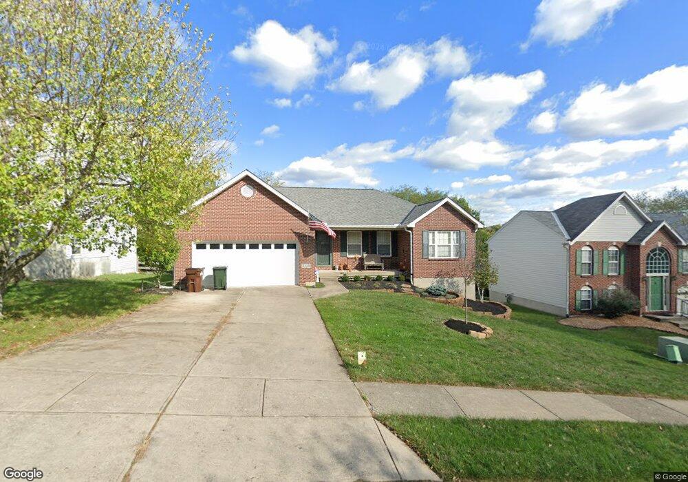
121 Aspen Ct Newport, KY 41071
Estimated Value: $287,042 - $363,000
3
Beds
3
Baths
1,382
Sq Ft
$247/Sq Ft
Est. Value
About This Home
This home is located at 121 Aspen Ct, Newport, KY 41071 and is currently estimated at $342,011, approximately $247 per square foot. 121 Aspen Ct is a home located in Campbell County with nearby schools including Newport Primary School, Newport Intermediate School, and Newport High School.
Ownership History
Date
Name
Owned For
Owner Type
Purchase Details
Closed on
Aug 21, 2006
Sold by
Wolke Jerome and Wolke Nancy
Bought by
Wolke Jerome and Wolle Nancy
Current Estimated Value
Purchase Details
Closed on
Jul 30, 2003
Sold by
Strange John E and Strange Bethany L
Bought by
Wolke Jerome and Wolke Nancy
Purchase Details
Closed on
Nov 4, 1997
Sold by
Parkland Homes Inc
Bought by
John E & Bethany L Strange
Home Financials for this Owner
Home Financials are based on the most recent Mortgage that was taken out on this home.
Original Mortgage
$93,319
Interest Rate
6.88%
Mortgage Type
New Conventional
Purchase Details
Closed on
Sep 8, 1997
Sold by
Aspen Corp
Bought by
Parkland Homes Inc
Home Financials for this Owner
Home Financials are based on the most recent Mortgage that was taken out on this home.
Original Mortgage
$93,319
Interest Rate
6.88%
Mortgage Type
New Conventional
Create a Home Valuation Report for This Property
The Home Valuation Report is an in-depth analysis detailing your home's value as well as a comparison with similar homes in the area
Home Values in the Area
Average Home Value in this Area
Purchase History
| Date | Buyer | Sale Price | Title Company |
|---|---|---|---|
| Wolke Jerome | -- | None Available | |
| Wolke Jerome | $183,200 | Chicago Title Insurance Co | |
| John E & Bethany L Strange | $133,319 | -- | |
| Parkland Homes Inc | $76,000 | -- |
Source: Public Records
Mortgage History
| Date | Status | Borrower | Loan Amount |
|---|---|---|---|
| Previous Owner | John E & Bethany L Strange | $93,319 | |
| Previous Owner | Parkland Homes Inc | $500,000 |
Source: Public Records
Tax History Compared to Growth
Tax History
| Year | Tax Paid | Tax Assessment Tax Assessment Total Assessment is a certain percentage of the fair market value that is determined by local assessors to be the total taxable value of land and additions on the property. | Land | Improvement |
|---|---|---|---|---|
| 2024 | $678 | $222,500 | $50,000 | $172,500 |
| 2023 | $571 | $190,800 | $25,000 | $165,800 |
| 2022 | $667 | $190,800 | $25,000 | $165,800 |
| 2021 | $684 | $190,800 | $25,000 | $165,800 |
| 2020 | $702 | $190,800 | $25,000 | $165,800 |
| 2019 | $598 | $164,900 | $25,000 | $139,900 |
| 2018 | $597 | $164,900 | $25,000 | $139,900 |
| 2017 | $600 | $164,900 | $25,000 | $139,900 |
| 2016 | $572 | $164,900 | $0 | $0 |
| 2015 | $581 | $164,900 | $0 | $0 |
| 2014 | $573 | $164,900 | $0 | $0 |
Source: Public Records
Map
Nearby Homes
- 301 Snow Shoe Dr
- 249 Bluegrass Ave
- 190 Kentucky Dr
- 186 Kentucky Dr
- 43.5-45.5, Kentucky Dr
- 85 & 87 Kentucky Dr
- 100 Mayo Cir
- 42 Woodland Hills Dr Unit 7
- 118 Electric Ave
- 72 View Terrace Dr Unit 7
- 616 E 21st St
- 62 View Terrace Dr Unit 9
- 605 E 18th St
- 2115 Monmouth St
- 12 Amelia St
- 15 Custis Ave
- 2225 Oakland Ave
- 94 Home St
- 516 E 19th St
- 252 Linden Ave