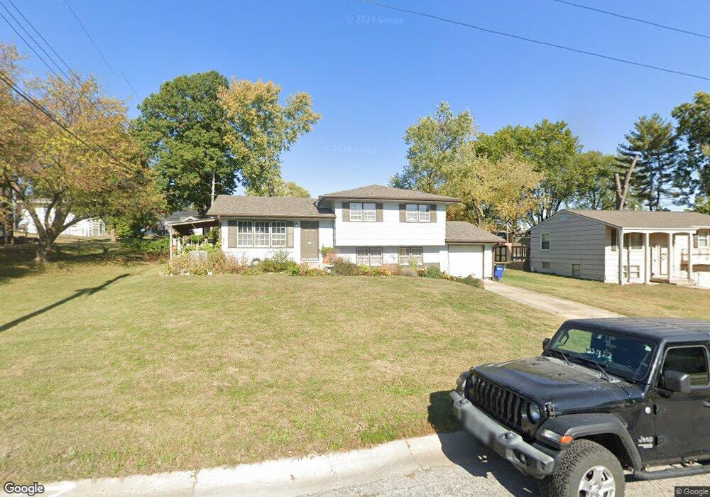
121 Avondale St Liberty, MO 64068
Estimated Value: $253,331 - $266,000
3
Beds
2
Baths
1,026
Sq Ft
$253/Sq Ft
Est. Value
About This Home
This home is located at 121 Avondale St, Liberty, MO 64068 and is currently estimated at $259,583, approximately $253 per square foot. 121 Avondale St is a home located in Clay County with nearby schools including Alexander Doniphan Elementary School, Discovery Middle School, and Liberty High School.
Ownership History
Date
Name
Owned For
Owner Type
Purchase Details
Closed on
Jun 27, 1997
Sold by
Young Eleanor Patricia
Bought by
Young Jay P
Current Estimated Value
Home Financials for this Owner
Home Financials are based on the most recent Mortgage that was taken out on this home.
Original Mortgage
$51,943
Outstanding Balance
$7,071
Interest Rate
7.93%
Mortgage Type
FHA
Estimated Equity
$252,512
Create a Home Valuation Report for This Property
The Home Valuation Report is an in-depth analysis detailing your home's value as well as a comparison with similar homes in the area
Home Values in the Area
Average Home Value in this Area
Purchase History
| Date | Buyer | Sale Price | Title Company |
|---|---|---|---|
| Young Jay P | -- | Chicago Title Insurance Co |
Source: Public Records
Mortgage History
| Date | Status | Borrower | Loan Amount |
|---|---|---|---|
| Open | Young Jay P | $51,943 |
Source: Public Records
Tax History Compared to Growth
Tax History
| Year | Tax Paid | Tax Assessment Tax Assessment Total Assessment is a certain percentage of the fair market value that is determined by local assessors to be the total taxable value of land and additions on the property. | Land | Improvement |
|---|---|---|---|---|
| 2025 | $2,120 | $31,500 | -- | -- |
| 2024 | $2,120 | $27,570 | -- | -- |
| 2023 | $2,156 | $27,570 | $0 | $0 |
| 2022 | $2,003 | $25,290 | $0 | $0 |
| 2021 | $1,988 | $25,289 | $6,650 | $18,639 |
| 2020 | $1,969 | $23,520 | $0 | $0 |
| 2019 | $1,968 | $23,520 | $0 | $0 |
| 2018 | $1,661 | $19,490 | $0 | $0 |
| 2017 | $1,646 | $19,490 | $3,800 | $15,690 |
| 2016 | $1,646 | $19,490 | $3,800 | $15,690 |
| 2015 | $1,646 | $19,490 | $3,800 | $15,690 |
| 2014 | $1,567 | $18,410 | $3,800 | $14,610 |
Source: Public Records
Map
Nearby Homes
- 415 Monterey Ave
- 420 Belmont St
- 509 Belmont St
- 1124 Amesbury Ave
- 918 Amesbury Ave
- 862 Amesbury Ave
- 1323 Amesbury Ave
- 1218 Canterbury Ln
- 1507 Amesbury Ave
- 716 Bristol Ct
- 1733 Welleslay Ln
- 253 S Stewart Rd
- 7908 N Ditzler Ave
- 1537 Canterbury Ln
- 9102 NE 79th Terrace
- 9005 NE 80th St
- 1331 Park Ln
- 11852 N Kentucky Ave
- 1317 Park Ln
- 1304 Wellington Way
- 117 Avondale St
- 311 Monterey Ave
- 307 Monterey Ave
- 113 Avondale St
- 124 Brentwood Dr
- 120 Brentwood Dr
- 122 Avondale St
- 116 Brentwood Dr
- 118 Avondale St
- 303 Monterey Ave
- 403 Monterey Ave
- 109 Avondale St
- 114 Avondale Ave
- 114 Avondale St
- 112 Brentwood Dr
- 314 Monterey Ave
- 318 Monterey Ave
- 110 Avondale St
- 108 Brentwood Dr
- 306 Monterey Ave