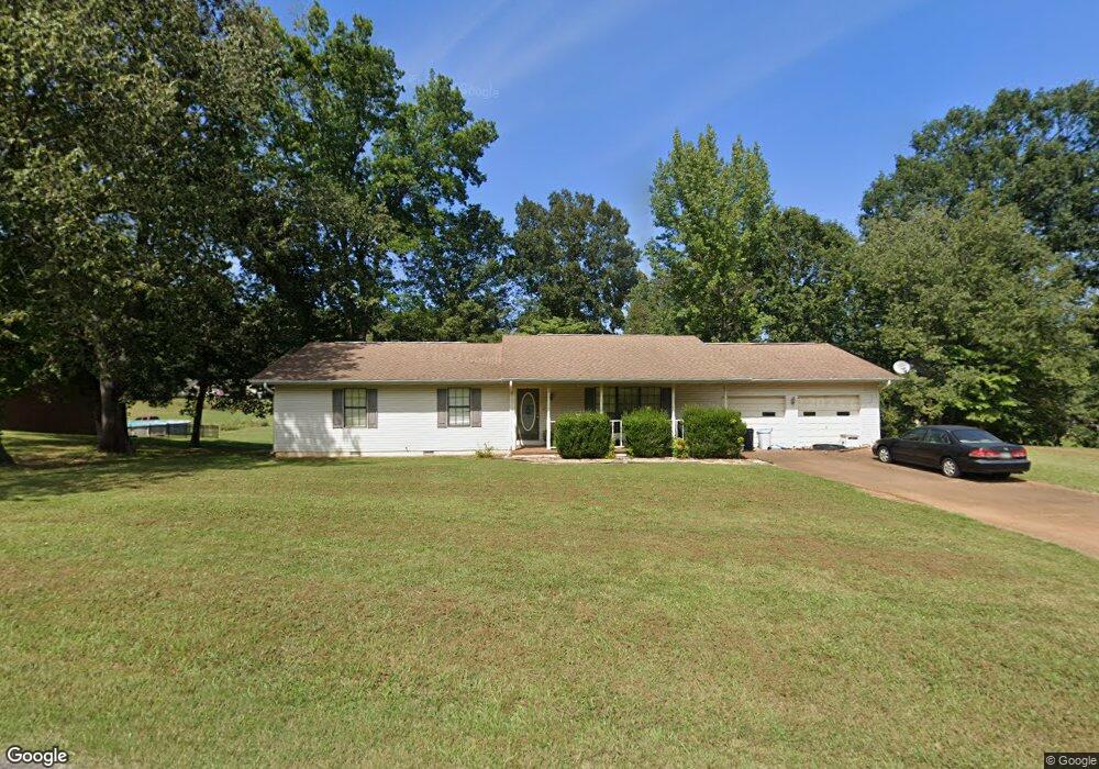
121 Cabin Dr Linden, TN 37096
Estimated Value: $194,345 - $301,000
Studio
2
Baths
1,549
Sq Ft
$163/Sq Ft
Est. Value
About This Home
This home is located at 121 Cabin Dr, Linden, TN 37096 and is currently estimated at $253,086, approximately $163 per square foot. 121 Cabin Dr is a home located in Perry County.
Ownership History
Date
Name
Owned For
Owner Type
Purchase Details
Closed on
Aug 14, 2007
Sold by
Bradley Bronson
Bought by
Bell Patricia
Current Estimated Value
Purchase Details
Closed on
Aug 10, 2007
Sold by
Turnbo Betty A
Bought by
Bradley Bronson
Purchase Details
Closed on
Aug 13, 2001
Bought by
Laster Thomas B and Laster Patricia A
Purchase Details
Closed on
Aug 7, 2001
Purchase Details
Closed on
May 7, 1998
Bought by
Ramey Peggie
Purchase Details
Closed on
May 6, 1998
Bought by
Mays Anthony and Mays Madeline
Purchase Details
Closed on
Mar 27, 1992
Bought by
Ramey Peggie
Create a Home Valuation Report for This Property
The Home Valuation Report is an in-depth analysis detailing your home's value as well as a comparison with similar homes in the area
Purchase History
| Date | Buyer | Sale Price | Title Company |
|---|---|---|---|
| Bell Patricia | $116,000 | -- | |
| Bradley Bronson | -- | -- | |
| Laster Thomas B | $83,000 | -- | |
| -- | -- | -- | |
| Ramey Peggie | -- | -- | |
| Mays Anthony | $75,000 | -- | |
| Ramey Peggie | -- | -- |
Source: Public Records
Tax History
| Year | Tax Paid | Tax Assessment Tax Assessment Total Assessment is a certain percentage of the fair market value that is determined by local assessors to be the total taxable value of land and additions on the property. | Land | Improvement |
|---|---|---|---|---|
| 2025 | -- | $29,500 | $3,000 | $26,500 |
| 2024 | $826 | $29,500 | $3,000 | $26,500 |
| 2023 | $825 | $29,500 | $3,000 | $26,500 |
| 2022 | $825 | $29,500 | $3,000 | $26,500 |
| 2021 | $825 | $29,500 | $3,000 | $26,500 |
| 2019 | $810 | $27,150 | $2,375 | $24,775 |
| 2018 | $810 | $27,150 | $2,375 | $24,775 |
| 2017 | $802 | $27,150 | $2,375 | $24,775 |
| 2016 | $802 | $27,150 | $2,375 | $24,775 |
| 2015 | $789 | $27,150 | $2,375 | $24,775 |
| 2014 | $789 | $27,150 | $2,375 | $24,775 |
| 2013 | $793 | $27,316 | $0 | $0 |
Source: Public Records
Map
Nearby Homes
- 122 Shelton St
- 239 Brooklyn Ave
- 141 Maple St
- 245 S Mill St
- 0 Church St
- 2082 Airport Ridge Rd
- 8072 Old Hohenwald Rd
- 4439 Old Hohenwald Rd Unit 60
- 5608 Old Hohenwald Rd
- 107 Possum Trot Ln
- 628 Starlight Dr Unit 176
- 8884 U S Highway 412
- 117 Wyatt Ln Unit 8
- 309 River Bluff Rd
- 2172 Airport Ridge Rd Unit 1
- Lot 5 Campers Ln
- Lot 4 Campers Ln
- Lot 9 Campers Ln
- Lot 7 Campers Ln
- Lot 8 Campers Ln
- 119 Cabin Dr
- 127 Cabin Dr
- 230 Southwood Dr
- 52 Tennessee 13
- 226 Southwood Dr
- 129 Cabin Dr
- 222 Southwood Dr
- 124 Cabin Dr
- 214 Southwood Dr
- 236 Southwood Dr
- 229 Southwood Dr
- 223 Southwood Dr
- 208 Southwood Dr
- 233 Southwood Dr
- 237 Southwood Dr
- 217 Southwood Dr
- 4850 Cedar Ave
- 228 Cedar Ave
- 230 Cedar Ave
- 142 Riverside Dr
Your Personal Tour Guide
Ask me questions while you tour the home.