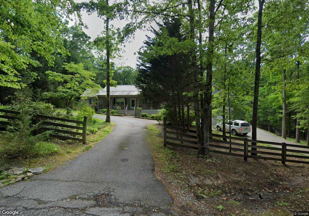
121 Camelot Way Clarkesville, GA 30523
Estimated Value: $438,000 - $642,000
5
Beds
5
Baths
2,440
Sq Ft
$202/Sq Ft
Est. Value
About This Home
This home is located at 121 Camelot Way, Clarkesville, GA 30523 and is currently estimated at $493,503, approximately $202 per square foot. 121 Camelot Way is a home located in Habersham County with nearby schools including Clarkesville Elementary School, North Habersham Middle School, and Habersham Success Academy.
Ownership History
Date
Name
Owned For
Owner Type
Purchase Details
Closed on
Aug 1, 2006
Sold by
Not Provided
Bought by
Jones Darrell Lee and Jones Grace B
Current Estimated Value
Create a Home Valuation Report for This Property
The Home Valuation Report is an in-depth analysis detailing your home's value as well as a comparison with similar homes in the area
Home Values in the Area
Average Home Value in this Area
Purchase History
| Date | Buyer | Sale Price | Title Company |
|---|---|---|---|
| Jones Darrell Lee | -- | -- |
Source: Public Records
Tax History Compared to Growth
Tax History
| Year | Tax Paid | Tax Assessment Tax Assessment Total Assessment is a certain percentage of the fair market value that is determined by local assessors to be the total taxable value of land and additions on the property. | Land | Improvement |
|---|---|---|---|---|
| 2025 | $47 | $183,341 | $16,376 | $166,965 |
| 2024 | -- | $179,192 | $11,124 | $168,068 |
| 2023 | $34 | $149,896 | $11,124 | $138,772 |
| 2022 | $24 | $129,992 | $11,124 | $118,868 |
| 2021 | $16 | $116,512 | $11,124 | $105,388 |
| 2020 | $2,201 | $101,556 | $11,124 | $90,432 |
| 2019 | $2,203 | $101,556 | $11,124 | $90,432 |
| 2018 | $2,197 | $101,556 | $11,124 | $90,432 |
| 2017 | $2,099 | $93,200 | $11,124 | $82,076 |
| 2016 | $2,024 | $233,000 | $11,124 | $82,076 |
| 2015 | $2,008 | $233,000 | $11,124 | $82,076 |
| 2014 | $2,011 | $226,820 | $11,124 | $79,604 |
| 2013 | -- | $90,728 | $11,124 | $79,604 |
Source: Public Records
Map
Nearby Homes
- 395 E Louise St
- 4230 Hollywood Hwy
- 253 Lacount Ln
- 409 Roper Dr
- 405 Roper Dr
- 135 Village Dr
- 205 Flesner Ct
- 382 Sherwood Dr
- 643 Washington St
- 745 Washington St
- 176 Llewellyn St
- 172 Llewellyn St
- 180 Llewellyn St
- 0 Ivy Ridge Way Unit LOT 40 10327774
- 0 Ivy Ridge Way Unit LOT 6 10487513
- 0 Ivy Ridge Way Unit LOT 50 10487398
- 325 Springwood Dr
- 0 Highlands Lake Trail Unit LOT 30 10600443
- 0 Highlands Lake Trail Unit 7646133
- 111 Smith Ct
- 240 Camelot Way
- 1089 Rocky Branch Rd
- 933 Rocky Branch Rd
- 4388 Toccoa Hwy
- 4336 Toccoa Hwy
- 4402 Toccoa Hwy
- 0 Toccoa Hwy Unit 7105557
- 0 Toccoa Hwy Unit 7592380
- 0 Toccoa Hwy Unit 3161392
- 0 Toccoa Hwy Unit 7595803
- 0 Toccoa Hwy Unit 7045346
- 0 Toccoa Hwy Unit 7611937
- 0 Toccoa Hwy Unit 8514580
- 0 Toccoa Hwy Unit 8946362
- 0 Toccoa Hwy Unit 7081256
- 870 E Louise St
- 844 E Louise St
- 0 E Louise St Unit 20028872
- 140 Sugar Hill Ln
- 466 Barron Dr