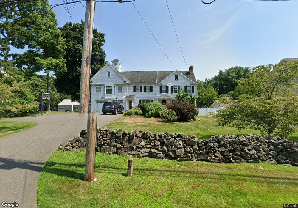
121 Elm St Fairfield, CT 06824
Fairfield Center NeighborhoodEstimated Value: $1,144,000 - $1,489,000
4
Beds
3
Baths
3,968
Sq Ft
$322/Sq Ft
Est. Value
About This Home
This home is located at 121 Elm St, Fairfield, CT 06824 and is currently estimated at $1,277,813, approximately $322 per square foot. 121 Elm St is a home located in Fairfield County with nearby schools including Osborn Hill Elementary School, Fairfield Woods Middle School, and Fairfield Ludlowe High School.
Ownership History
Date
Name
Owned For
Owner Type
Purchase Details
Closed on
Mar 16, 2005
Sold by
Swartz Donald H and Horsman Jennifer J
Bought by
Porta Marco Della and Trout Meredith
Current Estimated Value
Home Financials for this Owner
Home Financials are based on the most recent Mortgage that was taken out on this home.
Original Mortgage
$507,200
Outstanding Balance
$257,648
Interest Rate
5.64%
Estimated Equity
$1,020,165
Create a Home Valuation Report for This Property
The Home Valuation Report is an in-depth analysis detailing your home's value as well as a comparison with similar homes in the area
Home Values in the Area
Average Home Value in this Area
Purchase History
| Date | Buyer | Sale Price | Title Company |
|---|---|---|---|
| Porta Marco Della | $633,999 | -- | |
| Porta Marco Della | $633,999 | -- |
Source: Public Records
Mortgage History
| Date | Status | Borrower | Loan Amount |
|---|---|---|---|
| Open | Porta Marco Della | $507,200 | |
| Closed | Porta Marco Della | $507,200 |
Source: Public Records
Tax History Compared to Growth
Tax History
| Year | Tax Paid | Tax Assessment Tax Assessment Total Assessment is a certain percentage of the fair market value that is determined by local assessors to be the total taxable value of land and additions on the property. | Land | Improvement |
|---|---|---|---|---|
| 2025 | $16,475 | $580,300 | $298,060 | $282,240 |
| 2024 | $16,190 | $580,300 | $298,060 | $282,240 |
| 2023 | $15,964 | $580,300 | $298,060 | $282,240 |
| 2022 | $15,807 | $580,300 | $298,060 | $282,240 |
| 2021 | $15,656 | $580,300 | $298,060 | $282,240 |
| 2020 | $14,498 | $541,170 | $294,980 | $246,190 |
| 2019 | $14,498 | $541,170 | $294,980 | $246,190 |
| 2018 | $14,265 | $541,170 | $294,980 | $246,190 |
| 2017 | $13,973 | $541,170 | $294,980 | $246,190 |
| 2016 | $13,773 | $541,170 | $294,980 | $246,190 |
| 2015 | $12,746 | $514,150 | $310,660 | $203,490 |
| 2014 | $10,421 | $427,070 | $310,660 | $116,410 |
Source: Public Records
Map
Nearby Homes
- 20 Ermine St
- 38 Edge Hill Rd
- 122 Colony St
- 245 Unquowa Rd Unit 34
- 245 Unquowa Rd Unit 11
- 245 Unquowa Rd Unit 33
- 2180 Kings Hwy Unit 1
- 168 Wormwood Rd
- 15 Barton Rd
- 174 Sunnieholme Dr
- 117 Turney Rd
- 96 Clinton St
- 133 Green Acre Ln
- 83 Pell Meadow Dr
- 361 Riverside Dr
- 294 Catherine Terrace
- 345 Reef Rd Unit B6
- 345 Reef Rd Unit C9
- 378 Penfield Rd
- 21 Beaumont St