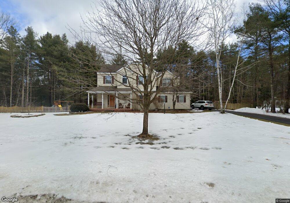
121 Hudson Pointe Blvd Queensbury, NY 12804
Estimated Value: $538,000 - $594,000
4
Beds
1
Bath
2,325
Sq Ft
$241/Sq Ft
Est. Value
About This Home
This home is located at 121 Hudson Pointe Blvd, Queensbury, NY 12804 and is currently estimated at $560,561, approximately $241 per square foot. 121 Hudson Pointe Blvd is a home located in Warren County with nearby schools including Queensbury Elementary School, William H. Barton Intermediate School, and Queensbury Middle School.
Ownership History
Date
Name
Owned For
Owner Type
Purchase Details
Closed on
Jan 21, 2016
Sold by
Murphy Nancy
Bought by
Lawrence Royce and Lawrence
Current Estimated Value
Home Financials for this Owner
Home Financials are based on the most recent Mortgage that was taken out on this home.
Original Mortgage
$295,919
Outstanding Balance
$235,505
Interest Rate
3.98%
Mortgage Type
New Conventional
Estimated Equity
$325,056
Purchase Details
Closed on
Nov 22, 1996
Sold by
The Michaels Group Llc
Bought by
Murphy Edward J and Murphy Nancy A
Create a Home Valuation Report for This Property
The Home Valuation Report is an in-depth analysis detailing your home's value as well as a comparison with similar homes in the area
Home Values in the Area
Average Home Value in this Area
Purchase History
| Date | Buyer | Sale Price | Title Company |
|---|---|---|---|
| Lawrence Royce | $325,293 | Lynn Acker | |
| Murphy Edward J | $165,570 | -- |
Source: Public Records
Mortgage History
| Date | Status | Borrower | Loan Amount |
|---|---|---|---|
| Open | Lawrence Royce | $295,919 |
Source: Public Records
Tax History Compared to Growth
Tax History
| Year | Tax Paid | Tax Assessment Tax Assessment Total Assessment is a certain percentage of the fair market value that is determined by local assessors to be the total taxable value of land and additions on the property. | Land | Improvement |
|---|---|---|---|---|
| 2024 | $8,204 | $406,000 | $70,000 | $336,000 |
| 2023 | $7,701 | $332,100 | $69,500 | $262,600 |
| 2022 | $7,379 | $332,100 | $69,500 | $262,600 |
| 2021 | $7,277 | $332,100 | $69,500 | $262,600 |
| 2020 | $2,007 | $319,000 | $69,500 | $249,500 |
| 2019 | $5,085 | $319,000 | $69,500 | $249,500 |
| 2018 | $7,016 | $319,000 | $69,500 | $249,500 |
| 2017 | $6,605 | $298,200 | $69,500 | $228,700 |
| 2016 | $6,510 | $298,200 | $69,500 | $228,700 |
| 2015 | -- | $298,200 | $69,500 | $228,700 |
| 2014 | -- | $230,200 | $36,900 | $193,300 |
Source: Public Records
Map
Nearby Homes
- 15 Hyde Ct
- 10 Mockingbird Ln
- 7 Mockingbird Ln
- 4 Mockingbird Ln
- 23 Revere Rd
- 377 Corinth Rd
- 2 Founders Way
- 129 Pitcher Rd
- 43 N Church Ln
- 151 W Mountain Rd
- 37 Stephanie Ln
- 4 Joseph Ct
- 251 Big Bay Rd
- 455 Luzerne Rd
- 50 Nicole Dr
- 19 Indiana Ave
- 54 Michigan Ave
- 195 Big Boom Rd
- 223 Luzerne Rd
- L43.2 Big Boom Rd
- 121 Hudson Pointe Blvd
- 115 Hudson Pointe Blvd
- 129 Hudson Pointe Blvd
- 122 Hudson Pointe Blvd
- 24 Danford Ct
- 132 Hudson Pointe Blvd
- 111 Hudson Pointe Blvd
- 114 Hudson Pointe Blvd
- 28 Danford Ct
- 135 Hudson Pointe Blvd
- 20 Danford Ct
- 142 Hudson Pointe Blvd
- 103 Hudson Pointe Blvd
- 104 Hudson Pointe Blvd
- 27 Danford Ct
- 12 Danford Ct
- 141 Hudson Pointe Blvd
- 7 Hyde Ct
- 0 Danford Ct
- 25 Danford Ct