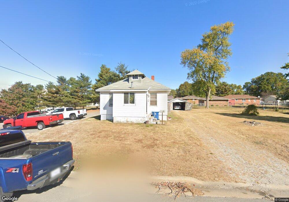
121 Manning Ave Wood River, IL 62095
Estimated Value: $86,121 - $109,000
3
Beds
1
Bath
816
Sq Ft
$122/Sq Ft
Est. Value
About This Home
This home is located at 121 Manning Ave, Wood River, IL 62095 and is currently estimated at $99,280, approximately $121 per square foot. 121 Manning Ave is a home located in Madison County with nearby schools including Eastwood Elementary School, East Alton Middle School, and East Alton-Wood River High School.
Ownership History
Date
Name
Owned For
Owner Type
Purchase Details
Closed on
Jan 12, 2024
Sold by
Werts Robert R and Werts Verna F
Bought by
Arendco Llc
Current Estimated Value
Home Financials for this Owner
Home Financials are based on the most recent Mortgage that was taken out on this home.
Original Mortgage
$22,400
Interest Rate
3.96%
Mortgage Type
Commercial
Purchase Details
Closed on
Dec 1, 2006
Sold by
Hulvey Karen J and Werts Dwight A
Bought by
Hulvey Karen J and Werts Dwight A
Purchase Details
Closed on
Aug 11, 2004
Sold by
Hulvey Karen J and Werts Dwight A
Bought by
Hulvey Karen J and Werts Dwight A
Create a Home Valuation Report for This Property
The Home Valuation Report is an in-depth analysis detailing your home's value as well as a comparison with similar homes in the area
Home Values in the Area
Average Home Value in this Area
Purchase History
| Date | Buyer | Sale Price | Title Company |
|---|---|---|---|
| Arendco Llc | $28,000 | Community Title & Escrow | |
| Hulvey Karen J | -- | None Available | |
| Hulvey Karen J | -- | None Available | |
| Hulvey Karen J | -- | None Available | |
| Hulvey Karen J | -- | -- |
Source: Public Records
Mortgage History
| Date | Status | Borrower | Loan Amount |
|---|---|---|---|
| Previous Owner | Arendco Llc | $22,400 |
Source: Public Records
Tax History Compared to Growth
Tax History
| Year | Tax Paid | Tax Assessment Tax Assessment Total Assessment is a certain percentage of the fair market value that is determined by local assessors to be the total taxable value of land and additions on the property. | Land | Improvement |
|---|---|---|---|---|
| 2024 | $1,757 | $20,480 | $2,690 | $17,790 |
| 2023 | $1,757 | $19,090 | $2,510 | $16,580 |
| 2022 | $1,669 | $19,220 | $3,860 | $15,360 |
| 2021 | $1,659 | $17,920 | $3,600 | $14,320 |
| 2020 | $1,623 | $17,260 | $3,470 | $13,790 |
| 2019 | $1,565 | $16,750 | $3,370 | $13,380 |
| 2018 | $1,519 | $15,930 | $3,210 | $12,720 |
| 2017 | $1,437 | $15,550 | $3,130 | $12,420 |
| 2016 | $1,416 | $15,550 | $3,130 | $12,420 |
| 2015 | $1,405 | $15,390 | $3,100 | $12,290 |
| 2014 | $1,405 | $15,390 | $3,100 | $12,290 |
| 2013 | $1,405 | $15,610 | $3,140 | $12,470 |
Source: Public Records
Map
Nearby Homes
- 726 Rice St
- 833 State St
- 777 Condit St
- 209 Elble Ave
- 830 N Wood River Ave
- 98 Wood River Ave
- 133 Lincoln Ave
- 330 S Pence St
- 121 Whitelaw Ave
- 104 Whitelaw Ave
- 41 W Penning Ave
- 469 N 1st St
- 641 Leslie Ave
- 959 Cedar Dr
- 72 E Acton Ave
- 109 S Shamrock St
- 145 Victory Dr
- 140 Victory Dr
- 207 E Penning Ave
- 420 Bowman Ave
- 346 Vanpreter Ave
- 115 Manning Ave
- 346 van Preter Ave
- 334 Vanpreter Ave
- 360 Vanpreter Ave
- 360 Manning Ave
- 350 Manning Ave
- 330 Vanpreter Ave
- 111 Manning Ave
- 120 Manning Ave
- 326 Vanpreter Ave
- 311 Manning Ave
- 116 Manning Ave
- 345 van Preter Ave
- 360 Old St Louis Rd
- 110 Manning Ave
- 345 Vanpreter Ave
- 351 Vanpreter Ave
- 337 Vanpreter Ave
- 137 Harnett Ave