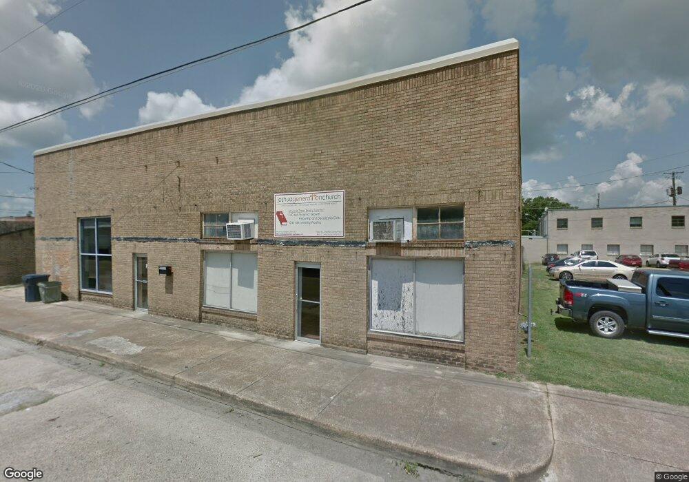
121 N Mulberry St Tallulah, LA 71282
Estimated Value: $110,698
--
Bed
2
Baths
4,290
Sq Ft
$26/Sq Ft
Est. Value
About This Home
This home is located at 121 N Mulberry St, Tallulah, LA 71282 and is currently estimated at $110,698, approximately $25 per square foot. 121 N Mulberry St is a home located in Madison Parish with nearby schools including Tallulah Charter School and Tallulah Academy - Delta Christian School.
Ownership History
Date
Name
Owned For
Owner Type
Purchase Details
Closed on
Jul 26, 2018
Sold by
Coachs Bar & Grill Llp
Bought by
Landers Tracy R
Current Estimated Value
Home Financials for this Owner
Home Financials are based on the most recent Mortgage that was taken out on this home.
Original Mortgage
$92,000
Outstanding Balance
$79,898
Interest Rate
4.5%
Mortgage Type
Unknown
Estimated Equity
$30,800
Purchase Details
Closed on
Jun 7, 2016
Sold by
Joshua Generation M B Church
Bought by
Coachs Bar And Grill Llp
Home Financials for this Owner
Home Financials are based on the most recent Mortgage that was taken out on this home.
Original Mortgage
$61,512
Interest Rate
3.57%
Mortgage Type
Unknown
Create a Home Valuation Report for This Property
The Home Valuation Report is an in-depth analysis detailing your home's value as well as a comparison with similar homes in the area
Home Values in the Area
Average Home Value in this Area
Purchase History
| Date | Buyer | Sale Price | Title Company |
|---|---|---|---|
| Landers Tracy R | $85,000 | -- | |
| Coachs Bar And Grill Llp | $74,000 | -- |
Source: Public Records
Mortgage History
| Date | Status | Borrower | Loan Amount |
|---|---|---|---|
| Open | Landers Tracy R | $92,000 | |
| Previous Owner | Coachs Bar And Grill Llp | $61,512 |
Source: Public Records
Tax History Compared to Growth
Tax History
| Year | Tax Paid | Tax Assessment Tax Assessment Total Assessment is a certain percentage of the fair market value that is determined by local assessors to be the total taxable value of land and additions on the property. | Land | Improvement |
|---|---|---|---|---|
| 2024 | $1,613 | $11,799 | $2,106 | $9,693 |
| 2023 | $1,278 | $11,799 | $2,106 | $9,693 |
| 2022 | $1,635 | $11,799 | $2,106 | $9,693 |
| 2021 | $1,634 | $11,799 | $2,106 | $9,693 |
| 2020 | $1,633 | $11,799 | $2,106 | $9,693 |
| 2019 | $1,327 | $9,620 | $2,106 | $7,514 |
| 2018 | $1,336 | $9,620 | $2,106 | $7,514 |
| 2017 | $1,336 | $9,620 | $2,106 | $7,514 |
| 2016 | $1,336 | $9,620 | $2,106 | $7,514 |
Source: Public Records
Map
Nearby Homes
- 300 S Lincoln St
- 00 Highway 65 Unit 10.88 acres
- 0 Highway 65 Unit 5.054 acres
- 402 S Lincoln St
- 000 Highway 65
- 408 N Lincoln St
- 820 van Zelfden St
- 1200 Louisiana St
- 1204 Louisiana St
- 1222 Mississippi St
- 1104 Maple St
- 1504 Mississippi St
- 315 Garfield St
- 111 Burnside Dr
- 114 Burnside Dr
- 0 Felicia Dr Unit 14.22 acres 214011
- 0 Felicia Dr Unit 9.833 acres 214010
- 0 Felicia Dr Unit 24.05 acres
- 208 Sheri Kay St
- 105 Belle Ln
- 108 N Mulberry St
- 108 N Cedar St
- 203 N Mulberry St
- 0 U S 80 Unit 190828
- 0 U S 80 Unit 163949
- 401 S Cedar St
- 510 E Askew St
- 302 N Mulberry St
- 712 N Beech St
- 608 E Askew St
- 610 E Askew St
- 315 N Mulberry St
- 123 Kennedy Dr
- 100 S Chestnut St
- 103 Bebb Ln
- 118 S Lincoln St
- 106 S Lincoln St
- 116 S Lincoln St
- 400 E Askew St
- 322 E Green St