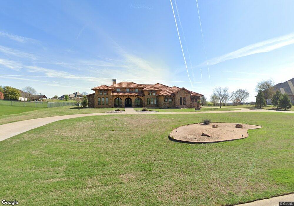
121 Pinnacle Peak Ln Weatherford, TX 76087
Estimated Value: $830,000 - $1,161,000
--
Bed
--
Bath
3,404
Sq Ft
$288/Sq Ft
Est. Value
About This Home
This home is located at 121 Pinnacle Peak Ln, Weatherford, TX 76087 and is currently estimated at $980,493, approximately $288 per square foot. 121 Pinnacle Peak Ln is a home with nearby schools including Brock Intermediate School, Brock Junior High School, and Brock High School.
Ownership History
Date
Name
Owned For
Owner Type
Purchase Details
Closed on
Oct 6, 2020
Sold by
Chester Jo Ann
Bought by
Chester Jo Ann
Current Estimated Value
Purchase Details
Closed on
Oct 30, 2015
Sold by
Bison Land Corporation
Bought by
Chester Glenn M and Chester Jo Ann
Purchase Details
Closed on
Jun 6, 2013
Sold by
Durham Phillip K and Durham Linda M
Bought by
Chester Glenn M and Jo Ann
Purchase Details
Closed on
May 10, 2013
Sold by
Maples Tony and Maples Louise
Bought by
Durham Phillip K and Durham Linda M
Purchase Details
Closed on
Sep 9, 2008
Sold by
Mickle Wesley J
Bought by
Maples Tony and Maples Louise
Purchase Details
Closed on
Mar 8, 2000
Bought by
Chester Glenn M and Jo Ann
Create a Home Valuation Report for This Property
The Home Valuation Report is an in-depth analysis detailing your home's value as well as a comparison with similar homes in the area
Home Values in the Area
Average Home Value in this Area
Purchase History
| Date | Buyer | Sale Price | Title Company |
|---|---|---|---|
| Chester Jo Ann | -- | None Available | |
| Chester Glenn M | -- | Providence Title Company | |
| Chester Glenn M | -- | -- | |
| Bison Land Corporation | -- | Capital Title | |
| Durham Phillip K | -- | Capital Title | |
| Maples Tony | -- | Sendera Title | |
| Chester Glenn M | -- | -- |
Source: Public Records
Tax History Compared to Growth
Tax History
| Year | Tax Paid | Tax Assessment Tax Assessment Total Assessment is a certain percentage of the fair market value that is determined by local assessors to be the total taxable value of land and additions on the property. | Land | Improvement |
|---|---|---|---|---|
| 2025 | $8,538 | $1,004,711 | -- | -- |
| 2024 | $8,538 | $913,374 | -- | -- |
| 2023 | $8,538 | $830,340 | $0 | $0 |
| 2022 | $15,325 | $754,860 | $80,000 | $674,860 |
| 2021 | $16,116 | $754,860 | $80,000 | $674,860 |
| 2020 | $14,198 | $661,190 | $75,000 | $586,190 |
| 2019 | $13,898 | $661,190 | $75,000 | $586,190 |
| 2018 | $12,691 | $542,120 | $60,000 | $482,120 |
| 2017 | $12,472 | $542,120 | $60,000 | $482,120 |
| 2016 | $1,380 | $60,000 | $60,000 | $0 |
| 2015 | $1,363 | $60,000 | $60,000 | $0 |
| 2014 | $1,377 | $60,000 | $60,000 | $0 |
Source: Public Records
Map
Nearby Homes
- 123 Club House Dr
- 162 Pinnacle Peak Ln
- 113 Laser Ln
- 197 Pinnacle Peak Ln
- 234 Trail Ridge
- 205 Pinnacle Peak Ln
- 120 Trail Ridge
- 150 Top Flight Dr
- 0 Quanah Hill Rd Unit 23872058
- 101 Trail Ridge
- 125 Summer Stone Ct
- 1060 Kessler Rd
- 2053 Verona Dr
- 313 Canyon Creek Cir
- 873 Canyon Creek Ln
- 2042 Verona Dr
- 2030 Verona Dr
- 304 Red Roan Ridge
- 393 Canyon Creek Cir
- 2026 Verona Dr
- 117 Pinnacle Peak Ln
- 125 Pinnacle Peak Ln
- 122 Pinnacle Peak Ln
- Lot 81 Condor View
- 0 Ultra Ct Unit 10855932
- L8182 Condor View
- 129 Pinnacle Peak Ln
- 101 Condor View
- 104 Ultra Ct
- 113 Pinnacle Peak Ln
- 105 Ultra Ct
- 128 Pinnacle Peak Ln
- 113 Condor View
- 122 Club House Dr
- 109 Pinnacle Peak Ln
- 134 Pinnacle Peak Ln
- 119 Condor View
- 114 Club House Dr
- 116 Club House Dr
- 106 Pinnacle Peak Ln