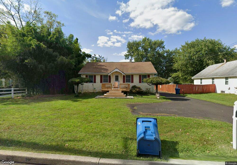
121 Richardson Rd Lansdale, PA 19446
Estimated Value: $390,000 - $539,000
2
Beds
1
Bath
2,194
Sq Ft
$215/Sq Ft
Est. Value
About This Home
This home is located at 121 Richardson Rd, Lansdale, PA 19446 and is currently estimated at $471,650, approximately $214 per square foot. 121 Richardson Rd is a home located in Montgomery County with nearby schools including Bridle Path Elementary School, Penndale Middle School, and North Penn Senior High School.
Ownership History
Date
Name
Owned For
Owner Type
Purchase Details
Closed on
Jul 23, 2025
Sold by
Loomis Walter C
Bought by
Loomis Walter C and Loomis Danette M
Current Estimated Value
Purchase Details
Closed on
Apr 6, 2009
Sold by
Loomis Dorothy M and Loomis Walter C
Bought by
Loomis Walter C
Home Financials for this Owner
Home Financials are based on the most recent Mortgage that was taken out on this home.
Original Mortgage
$254,375
Interest Rate
5.02%
Purchase Details
Closed on
Jan 12, 1998
Sold by
Rickert Russell L and Rickert Betty J
Bought by
Loomis Walter C and Loomis Dorothy M
Create a Home Valuation Report for This Property
The Home Valuation Report is an in-depth analysis detailing your home's value as well as a comparison with similar homes in the area
Home Values in the Area
Average Home Value in this Area
Purchase History
| Date | Buyer | Sale Price | Title Company |
|---|---|---|---|
| Loomis Walter C | -- | None Listed On Document | |
| Loomis Walter C | -- | None Listed On Document | |
| Loomis Walter C | -- | None Available | |
| Loomis Walter C | $129,900 | -- | |
| Loomis Walter C | $129,900 | -- |
Source: Public Records
Mortgage History
| Date | Status | Borrower | Loan Amount |
|---|---|---|---|
| Previous Owner | Loomis Walter C | $254,375 |
Source: Public Records
Tax History Compared to Growth
Tax History
| Year | Tax Paid | Tax Assessment Tax Assessment Total Assessment is a certain percentage of the fair market value that is determined by local assessors to be the total taxable value of land and additions on the property. | Land | Improvement |
|---|---|---|---|---|
| 2025 | $4,473 | $119,880 | $45,790 | $74,090 |
| 2024 | $4,473 | $119,880 | $45,790 | $74,090 |
| 2023 | $4,267 | $119,880 | $45,790 | $74,090 |
| 2022 | $4,117 | $119,880 | $45,790 | $74,090 |
| 2021 | $3,870 | $119,880 | $45,790 | $74,090 |
| 2020 | $3,768 | $119,880 | $45,790 | $74,090 |
| 2019 | $3,698 | $119,880 | $45,790 | $74,090 |
| 2018 | $596 | $119,880 | $45,790 | $74,090 |
| 2017 | $3,540 | $119,880 | $45,790 | $74,090 |
| 2016 | $3,494 | $119,880 | $45,790 | $74,090 |
| 2015 | $3,336 | $119,880 | $45,790 | $74,090 |
| 2014 | $3,336 | $119,880 | $45,790 | $74,090 |
Source: Public Records
Map
Nearby Homes
- 206 Broad Acres Rd
- 417 Wynstone Ct
- 303 Wynstone Ct
- 83 Bethlehem Pike Unit 1213 FIRESTONE
- 83 Bethlehem Pike Unit 1106- MADISON PLAN
- 100 Victoria Dr
- 6 Lantern Ln
- 000 Lenape Dr
- 304 Victoria Dr
- 2943 E Walnut St Unit 59
- 110 Country Club Dr
- 405 Country Club Dr
- 527 Lexington Ave
- 2111 Hidden Meadow Dr
- 534 Airy Ave
- 103 Dylan Dr Unit 45
- 1823 N Line St
- 117 Brianna Ct
- 119 Brianna Ct Unit 10
- 111 Brianna Ct Unit 6
- 123 Richardson Rd
- 204 Cricklewood Cir
- 202 Cricklewood Cir
- 101 Deerpath Dr
- 206 Cricklewood Cir Unit 94
- 200 Cricklewood Cir
- 208 Cricklewood Cir
- 125 Richardson Rd
- 103 Deerpath Dr
- 210 Cricklewood Cir
- 105 Deerpath Dr
- 212 Cricklewood Cir
- 101 Veronica Ln
- 107 Deerpath Dr
- 214 Cricklewood Cir
- 102 Deerpath Dr Unit B
- 102 Deerpath Dr
- 102 Deerpath Dr Unit A
- 300 Cricklewood Cir
- 109 Deerpath Dr