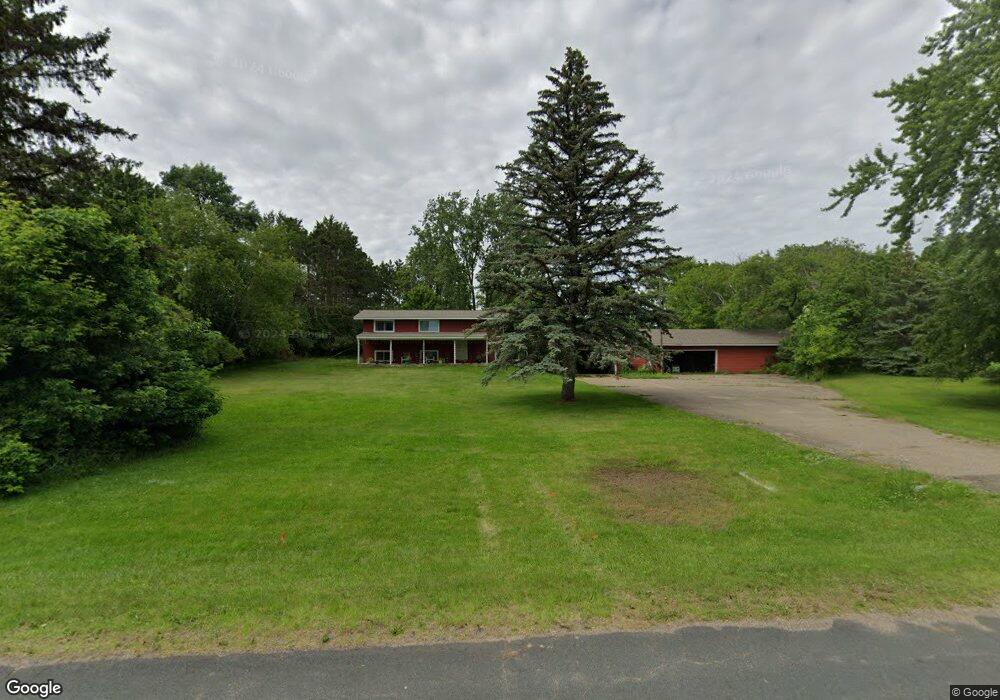
1210 1210 172nd-Avenue- Richmond, WI 54017
Estimated Value: $289,000 - $360,000
4
Beds
2
Baths
--
Sq Ft
1.26
Acres
About This Home
This home is located at 1210 1210 172nd-Avenue-, Richmond, WI 54017 and is currently estimated at $333,636. 1210 1210 172nd-Avenue- is a home located in St. Croix County with nearby schools including New Richmond High School and St. Mary School.
Ownership History
Date
Name
Owned For
Owner Type
Purchase Details
Closed on
Mar 31, 2015
Sold by
Schacker Gregory J and Schacker Suzan M
Bought by
Pearson Richard N and Pearson Survivor S T Richard N
Current Estimated Value
Purchase Details
Closed on
Jul 26, 2010
Sold by
Fannie Mae
Bought by
Schacker Greg and Schacker Sue
Purchase Details
Closed on
Mar 30, 2010
Sold by
Broich Maureen K
Bought by
Federal National Mortgage Association
Create a Home Valuation Report for This Property
The Home Valuation Report is an in-depth analysis detailing your home's value as well as a comparison with similar homes in the area
Home Values in the Area
Average Home Value in this Area
Purchase History
| Date | Buyer | Sale Price | Title Company |
|---|---|---|---|
| Pearson Richard N | $130,000 | None Available | |
| Schacker Greg | -- | None Available | |
| Federal National Mortgage Association | -- | None Available |
Source: Public Records
Tax History Compared to Growth
Tax History
| Year | Tax Paid | Tax Assessment Tax Assessment Total Assessment is a certain percentage of the fair market value that is determined by local assessors to be the total taxable value of land and additions on the property. | Land | Improvement |
|---|---|---|---|---|
| 2024 | $30 | $235,500 | $40,100 | $195,400 |
| 2023 | $2,821 | $235,500 | $40,100 | $195,400 |
| 2022 | $2,462 | $235,500 | $40,100 | $195,400 |
| 2021 | $2,529 | $235,500 | $40,100 | $195,400 |
| 2020 | $2,795 | $156,200 | $16,600 | $139,600 |
| 2019 | $2,702 | $156,200 | $16,600 | $139,600 |
| 2018 | $2,593 | $156,200 | $16,600 | $139,600 |
| 2017 | $2,534 | $156,200 | $16,600 | $139,600 |
| 2016 | $2,534 | $156,200 | $16,600 | $139,600 |
| 2015 | $2,629 | $156,200 | $16,600 | $139,600 |
| 2014 | $2,540 | $156,200 | $16,600 | $139,600 |
| 2013 | $2,430 | $156,200 | $16,600 | $139,600 |
Source: Public Records
Map
Nearby Homes
- 1142 W Edge Place
- 1050 Pheasant Run
- 1141 Pinewood Trail
- 1337 Eagle Ct
- 1016 W Ridge Ct
- 1272 Pheasant Run
- 941 W Edge Place Unit 14
- 1343 Creekwood Dr
- 1176 Carroll St
- 1549 Creekwood Dr
- TBD County Road A
- 1517 Creekwood Dr
- 1513 Creekwood Dr
- Kenny Plan at The Creek at Gloverdale
- Nora Plan at The Creek at Gloverdale
- Hudson Plan at The Creek at Gloverdale
- Aspen Plan at The Creek at Gloverdale
- Alder Plan at The Creek at Gloverdale
- Riley Plan at The Creek at Gloverdale
- Ashlyn Plan at The Creek at Gloverdale
- 1210 1210 172nd Ave
- 1210 172nd Ave
- 1206 172nd Ave
- 1206 1206 172nd-Avenue-
- 1214 172nd Ave
- 1055 Sharptail Run
- 1061 Sharptail Run
- 1049 Sharptail Run
- 1065 Sharptail Run
- 1041 Sharptail Run
- 1105 Sharptail Run
- 1209 172nd Ave
- Lot 35 Sharptail Run
- Lot 30 Sharptail Run
- Lot 12 Sharptail Run
- LOT 17 Sharptail Dr
- 1109 Sharptail Run
- 1035 Sharptail Run
- 1205 172nd Ave
- 1213 172nd Ave