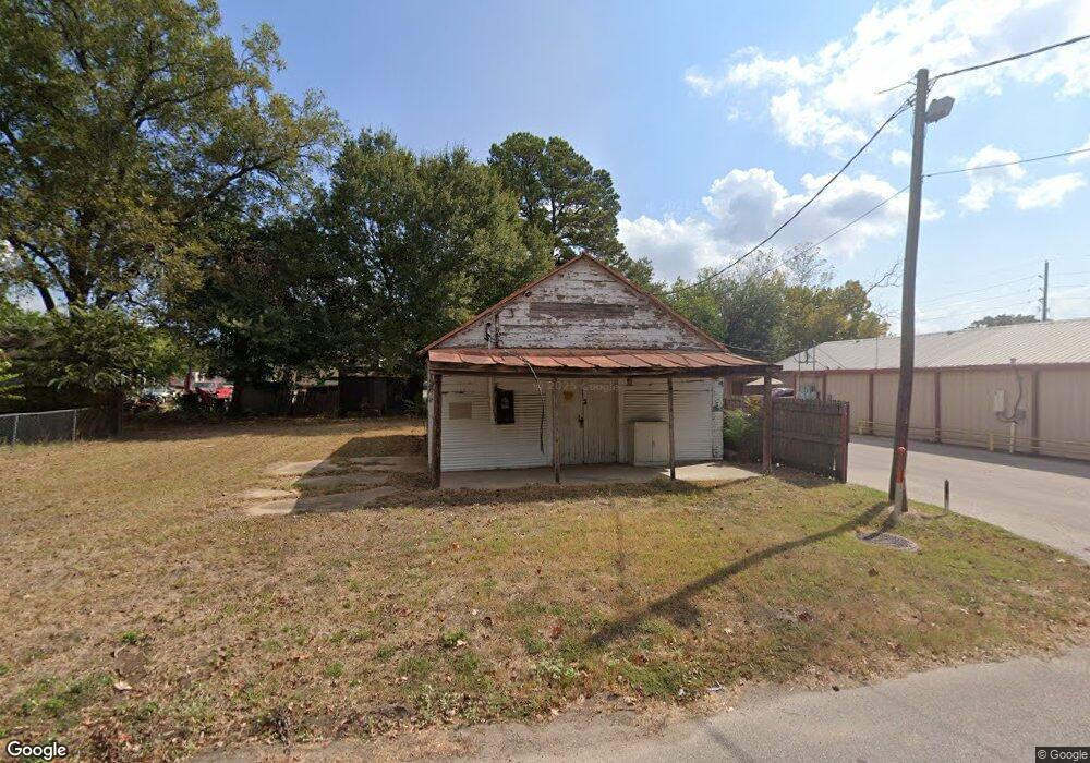
1210 Alliance St Waller, TX 77484
--
Bed
--
Bath
744
Sq Ft
6,098
Sq Ft Lot
About This Home
This home is located at 1210 Alliance St, Waller, TX 77484. 1210 Alliance St is a home located in Waller County with nearby schools including I.T. Holleman Elementary School, Waller Junior High School, and Waller High School.
Ownership History
Date
Name
Owned For
Owner Type
Purchase Details
Closed on
Aug 31, 2021
Sold by
Patrizio Zannone
Bought by
Jimenez Jesse Lee and Jimenez Anna Deleon
Purchase Details
Closed on
May 28, 2021
Sold by
Zannone Joseph Patrizio and Zannone Mariah
Bought by
Zannone Patrizio
Purchase Details
Closed on
Mar 26, 2021
Sold by
Zannone Patrizio
Bought by
Zannone Joseph Patrizio and Zannone Mariah Theresa
Purchase Details
Closed on
Apr 23, 2009
Sold by
Glueck Howard
Bought by
Zannone Patrizio
Create a Home Valuation Report for This Property
The Home Valuation Report is an in-depth analysis detailing your home's value as well as a comparison with similar homes in the area
Home Values in the Area
Average Home Value in this Area
Purchase History
| Date | Buyer | Sale Price | Title Company |
|---|---|---|---|
| Jimenez Jesse Lee | -- | South Land Title | |
| Zannone Patrizio | -- | None Available | |
| Zannone Joseph Patrizio | -- | None Available | |
| Zannone Patrizio | -- | None Available |
Source: Public Records
Tax History Compared to Growth
Tax History
| Year | Tax Paid | Tax Assessment Tax Assessment Total Assessment is a certain percentage of the fair market value that is determined by local assessors to be the total taxable value of land and additions on the property. | Land | Improvement |
|---|---|---|---|---|
| 2025 | $576 | $39,080 | $37,300 | $1,780 |
| 2024 | $576 | $39,080 | $37,300 | $1,780 |
| 2023 | $576 | $39,080 | $37,300 | $1,780 |
| 2022 | $380 | $21,130 | $19,350 | $1,780 |
| 2021 | $623 | $24,120 | $22,230 | $1,890 |
| 2020 | $636 | $24,120 | $22,230 | $1,890 |
| 2019 | $647 | $23,760 | $22,230 | $1,530 |
| 2018 | $609 | $23,190 | $21,660 | $1,530 |
| 2017 | $625 | $23,190 | $21,660 | $1,530 |
| 2016 | $579 | $21,480 | $19,950 | $1,530 |
| 2015 | $594 | $21,480 | $19,950 | $1,530 |
| 2014 | $594 | $21,480 | $19,950 | $1,530 |
Source: Public Records
Map
Nearby Homes
- 1203 Penick Rd
- 18633 Penick Rd
- 000 Sledge St
- 0 None Unit 78084118
- 221 Arborwood Dr
- 217 Arborwood Dr
- 2302 Main St
- 1707 Key St
- 0000 Cherry St
- 2707 Center St
- 2703 Holly St
- 0 Farm To Market 362
- 519 Elm St
- 40344 Business U S 290
- 1915 A St
- 2518 Daugherty St
- 2017 Penick Rd
- 307 Penick Rd
- 2411 Orange St
- 115 Penick Rd
- 2615 Taylor St
- 2611 Taylor St
- 2702 Cherry St
- 1218 Alliance St
- -0- Alliance St
- 2702 Taylor St
- 40648 Highway 290 Business
- 40648 Hwy 290 Business Unit A
- 40644 Highway 290 Business
- 2626 Highway 290 Business
- 40750 Highway 290 Business
- 2714 Cherry St
- 1303 Penick Rd
- 2702 Highway 290 Business
- Lot 7 Penick Rd
- Lot 8 Penick Rd
- TBD Penick Rd
- BLK 36 Penick Rd
- 00 Penick Rd
- 107 Penick Rd