Estimated Value: $407,557 - $450,000
4
Beds
2
Baths
2,636
Sq Ft
$162/Sq Ft
Est. Value
About This Home
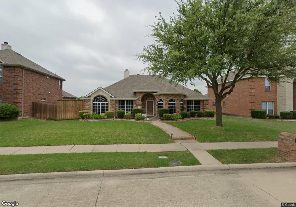
This home is located at 1210 E Oak St, Wylie, TX 75098 and is currently estimated at $426,139, approximately $161 per square foot. 1210 E Oak St is a home located in Collin County with nearby schools including P M Akin Elementary School, AB Harrison Intermediate School, and Grady Burnett J High School.
Ownership History
Date
Name
Owned For
Owner Type
Purchase Details
Closed on
Oct 29, 2014
Sold by
Martin Ronald L and Martin Sherrie L
Bought by
Awlachew Shenkute Z and Woldetekle Genet
Current Estimated Value
Home Financials for this Owner
Home Financials are based on the most recent Mortgage that was taken out on this home.
Original Mortgage
$136,200
Outstanding Balance
$105,287
Interest Rate
4.25%
Mortgage Type
New Conventional
Estimated Equity
$320,852
Purchase Details
Closed on
Feb 21, 2006
Sold by
D R Horton Texas Ltd
Bought by
Martin Ronald L and Martin Sherrie L
Home Financials for this Owner
Home Financials are based on the most recent Mortgage that was taken out on this home.
Original Mortgage
$120,760
Interest Rate
6.05%
Mortgage Type
Fannie Mae Freddie Mac
Create a Home Valuation Report for This Property
The Home Valuation Report is an in-depth analysis detailing your home's value as well as a comparison with similar homes in the area
Home Values in the Area
Average Home Value in this Area
Purchase History
| Date | Buyer | Sale Price | Title Company |
|---|---|---|---|
| Awlachew Shenkute Z | -- | Rtt | |
| Martin Ronald L | -- | None Available |
Source: Public Records
Mortgage History
| Date | Status | Borrower | Loan Amount |
|---|---|---|---|
| Open | Awlachew Shenkute Z | $136,200 | |
| Previous Owner | Martin Ronald L | $120,760 |
Source: Public Records
Tax History Compared to Growth
Tax History
| Year | Tax Paid | Tax Assessment Tax Assessment Total Assessment is a certain percentage of the fair market value that is determined by local assessors to be the total taxable value of land and additions on the property. | Land | Improvement |
|---|---|---|---|---|
| 2025 | $4,973 | $319,988 | $69,300 | $250,688 |
| 2024 | $4,973 | $295,987 | $69,300 | $242,326 |
| 2023 | $4,973 | $269,079 | $69,300 | $247,909 |
| 2022 | $5,367 | $244,617 | $59,400 | $216,594 |
| 2021 | $5,232 | $224,659 | $42,900 | $181,759 |
| 2020 | $5,020 | $202,163 | $42,900 | $159,263 |
| 2019 | $5,186 | $197,340 | $42,900 | $154,440 |
| 2018 | $5,213 | $193,580 | $36,300 | $157,280 |
| 2017 | $4,927 | $191,130 | $36,300 | $154,830 |
| 2016 | $7,002 | $252,000 | $40,000 | $212,000 |
| 2015 | $5,563 | $231,474 | $40,000 | $191,474 |
Source: Public Records
Map
Nearby Homes
- 1115 Nighthawk Dr
- 107 Windy Knoll Ln
- 1308 London Dr
- 1056 Fairview Dr
- 312 Maltese Cir
- 1209 Surrey Cir
- 213 N West A Allen Blvd
- 407 Sparrow Dr
- 1312 Wyndham Dr
- 205 Duck Blind Ave
- 209 Duck Blind Ave
- 207 Gatwick Ct
- 211 Rutherford Ave
- 306 Foxwood Ct
- 508 Weston St
- 1210 Troy Rd
- 2800 Gold Hill Dr
- 1201 E Stone Rd
- 1320 Cedar Branch Dr
- 409 Cedar Ridge Dr