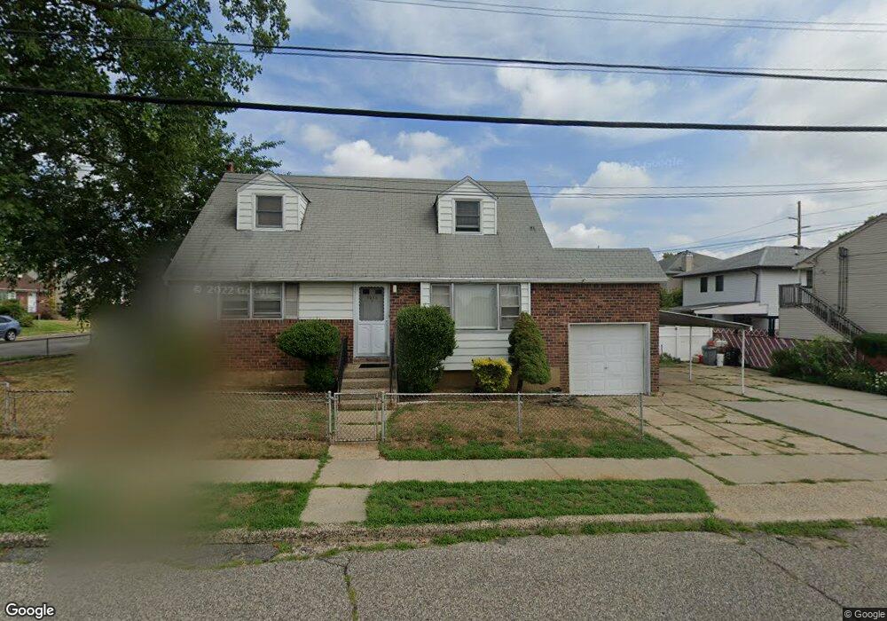
1210 Langdon St Franklin Square, NY 11010
Estimated Value: $717,000 - $721,458
4
Beds
1
Bath
1,186
Sq Ft
$606/Sq Ft
Est. Value
About This Home
This home is located at 1210 Langdon St, Franklin Square, NY 11010 and is currently estimated at $719,229, approximately $606 per square foot. 1210 Langdon St is a home located in Nassau County with nearby schools including St Anne's School.
Ownership History
Date
Name
Owned For
Owner Type
Purchase Details
Closed on
Jul 26, 2012
Sold by
Prete Ferdinando and Prete Anella
Bought by
Prete Ferdinando
Current Estimated Value
Home Financials for this Owner
Home Financials are based on the most recent Mortgage that was taken out on this home.
Original Mortgage
$11,741
Interest Rate
3.7%
Mortgage Type
New Conventional
Purchase Details
Closed on
Jun 24, 2005
Sold by
Lazzarano Andrew
Bought by
Prete Ferdinando
Purchase Details
Closed on
Jun 25, 2001
Sold by
Executor Gibbons John F
Bought by
Lazzarano Andrew
Create a Home Valuation Report for This Property
The Home Valuation Report is an in-depth analysis detailing your home's value as well as a comparison with similar homes in the area
Home Values in the Area
Average Home Value in this Area
Purchase History
| Date | Buyer | Sale Price | Title Company |
|---|---|---|---|
| Prete Ferdinando | -- | -- | |
| Prete Ferdinando | $420,000 | -- | |
| Lazzarano Andrew | $160,000 | Joseph Hunsberger |
Source: Public Records
Mortgage History
| Date | Status | Borrower | Loan Amount |
|---|---|---|---|
| Previous Owner | Prete Ferdinando | $11,741 |
Source: Public Records
Tax History Compared to Growth
Tax History
| Year | Tax Paid | Tax Assessment Tax Assessment Total Assessment is a certain percentage of the fair market value that is determined by local assessors to be the total taxable value of land and additions on the property. | Land | Improvement |
|---|---|---|---|---|
| 2025 | $10,565 | $482 | $247 | $235 |
| 2024 | $4,484 | $482 | $247 | $235 |
| 2023 | $11,131 | $482 | $247 | $235 |
| 2022 | $11,131 | $482 | $247 | $235 |
| 2021 | $15,142 | $473 | $242 | $231 |
| 2020 | $12,462 | $808 | $509 | $299 |
| 2019 | $12,726 | $808 | $509 | $299 |
| 2018 | $12,109 | $808 | $0 | $0 |
| 2017 | $6,725 | $808 | $509 | $299 |
| 2016 | $10,969 | $808 | $509 | $299 |
| 2015 | $3,946 | $808 | $509 | $299 |
| 2014 | $3,946 | $808 | $509 | $299 |
| 2013 | $3,685 | $808 | $509 | $299 |
Source: Public Records
Map
Nearby Homes
- 298 Doris Ave
- 191 Litchfield Ave
- 280 Franklin Ave Unit 11
- 342 Lucille Ave
- 206 Hunnewell Ave
- 291 Evans Ave
- 1280 Arlington Ave
- 1314 Globe Ave
- 147 Evans Ave
- 1116 Theodora St
- 335 Evans Ave
- 1134 Rosegold St
- 376 Hunnewell Ave
- 1311 Mcclure Ave
- 389 Hunnewell Ave
- 345 Evans Ave
- 89 Hunnewell Ave
- 1326 Citizen Ave
- 291 Lincoln St
- 1035 Wool Ave
- 209 Lucille Ave
- 207 Lucille Ave
- 1209 Langdon St
- 1190 Langdon St
- 208 Doris Ave
- 222 Doris Ave
- 201 Lucille Ave
- 1218 Langdon St
- 206 Doris Ave
- 227 Lucille Ave
- 210 Lucille Ave
- 228 Doris Ave
- 222 Lucille Ave
- 204 Lucille Ave
- 198 Doris Ave
- 231 Lucille Ave
- 231 Lucille Ave Unit 1
- 195 Lucille Ave
- 230 Lucille Ave
- 198 Lucille Ave