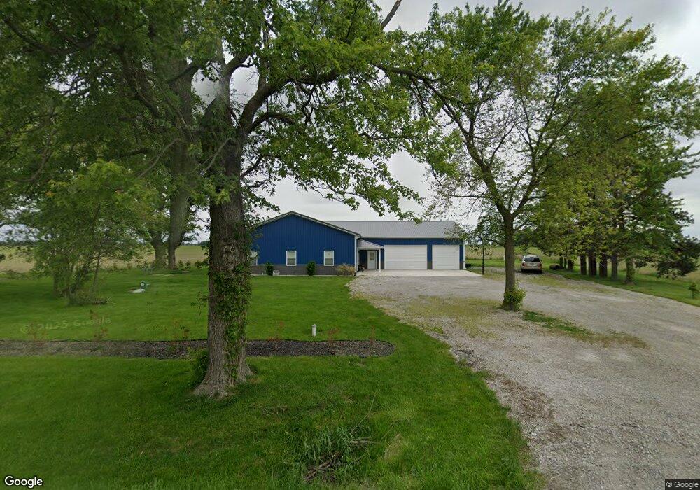
12102 State Route 49 Antwerp, OH 45813
Estimated Value: $211,180 - $233,000
3
Beds
2
Baths
2,000
Sq Ft
$111/Sq Ft
Est. Value
About This Home
This home is located at 12102 State Route 49, Antwerp, OH 45813 and is currently estimated at $221,045, approximately $110 per square foot. 12102 State Route 49 is a home located in Paulding County with nearby schools including Antwerp Local Elementary School and Antwerp Local High School.
Ownership History
Date
Name
Owned For
Owner Type
Purchase Details
Closed on
Jun 24, 2019
Sold by
Biddle Joseph K
Bought by
Bragg Robert H
Current Estimated Value
Purchase Details
Closed on
Mar 26, 2007
Sold by
Geyer Charlene K and Geyer Gregory
Bought by
Biddle Joseph K
Create a Home Valuation Report for This Property
The Home Valuation Report is an in-depth analysis detailing your home's value as well as a comparison with similar homes in the area
Home Values in the Area
Average Home Value in this Area
Purchase History
| Date | Buyer | Sale Price | Title Company |
|---|---|---|---|
| Bragg Robert H | $19,000 | None Available | |
| Biddle Joseph K | $16,000 | None Available |
Source: Public Records
Tax History Compared to Growth
Tax History
| Year | Tax Paid | Tax Assessment Tax Assessment Total Assessment is a certain percentage of the fair market value that is determined by local assessors to be the total taxable value of land and additions on the property. | Land | Improvement |
|---|---|---|---|---|
| 2024 | $1,813 | $51,880 | $3,190 | $48,690 |
| 2023 | $1,813 | $51,880 | $3,190 | $48,690 |
| 2022 | $1,770 | $51,880 | $3,190 | $48,690 |
| 2021 | $1,602 | $32,450 | $3,190 | $29,260 |
| 2020 | $1,259 | $5,500 | $3,190 | $2,310 |
| 2019 | $220 | $5,470 | $3,190 | $2,280 |
| 2018 | $215 | $5,470 | $3,190 | $2,280 |
| 2017 | $215 | $5,470 | $3,190 | $2,280 |
| 2016 | $215 | $5,470 | $3,190 | $2,280 |
| 2015 | $269 | $6,930 | $4,270 | $2,660 |
| 2014 | $267 | $6,930 | $4,270 | $2,660 |
| 2013 | $309 | $7,210 | $4,270 | $2,940 |
Source: Public Records
Map
Nearby Homes
- 5092 Road 176
- 208 W River St
- 309 N Madison St
- 13149 Road 27b
- 136 Maumee Ln
- 1258 Road 192
- 3190 Road 204
- 25812 Maumee Center Rd
- 16453 Road 63
- 100 Proxmire St
- 412 S Laura St
- 820 Brian Dr
- 24212 River Rd
- 11051 Road 93
- 4783 Legacy Cove
- 4602 Indiana 101
- 5038 Chickadee Dr
- 4974 Chickadee Dr
- 22428 Ash St Unit 25
- 22489 Ash St Unit 21
- 5187 Road 144
- 11778 State Route 49
- 5307 Road 144
- 11756 State Route 49
- 5385 Road 144
- 11619 State Route 49
- 11526 State Route 49
- 12681 Ohio 49
- 4391 Road 144
- 11436 State Route 49
- 5761 Road 144
- 5006 Road 162
- 4904 Road 162
- 5030 Road 162
- 5080 Road 162
- 17 Township Rd 43
- 19 Township Rd 43
- 5 Township Rd 43 Lot 5
- 1 Township Road 43
- 0 Township Rd 43 Lot 18