Estimated Value: $1,244,000 - $1,493,050
3
Beds
6
Baths
7,386
Sq Ft
$185/Sq Ft
Est. Value
About This Home
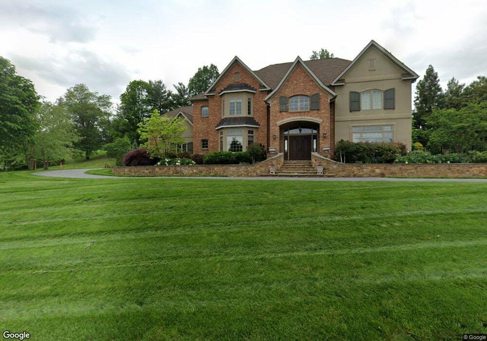
This home is located at 1211 Brookway Dr, York, PA 17403 and is currently estimated at $1,363,683, approximately $184 per square foot. 1211 Brookway Dr is a home located in York County with nearby schools including York Suburban Middle School, York Suburban Senior High School, and Lincoln Charter School.
Ownership History
Date
Name
Owned For
Owner Type
Purchase Details
Closed on
Jun 1, 2012
Sold by
Silk York Llc
Bought by
Rudy Paul L and Rudy Lori R
Current Estimated Value
Purchase Details
Closed on
Dec 17, 2008
Sold by
Grumbacher M Thomas and Grumbacher Nancy T
Bought by
Silk York Llc
Purchase Details
Closed on
Jul 31, 2006
Sold by
Grumbacher M Thomas and Grumbacher Nancy T
Bought by
Grumbacher M Thomas and Grumbacher Nancy T
Purchase Details
Closed on
Jun 11, 2004
Sold by
Mcgregor Mars George and Mcgregor Mars Mary
Bought by
Grumbacher M Thomas and Grumbacher Nancy T
Create a Home Valuation Report for This Property
The Home Valuation Report is an in-depth analysis detailing your home's value as well as a comparison with similar homes in the area
Home Values in the Area
Average Home Value in this Area
Purchase History
| Date | Buyer | Sale Price | Title Company |
|---|---|---|---|
| Rudy Paul L | $300,000 | None Available | |
| Silk York Llc | $500,000 | None Available | |
| Grumbacher M Thomas | -- | None Available | |
| Grumbacher M Thomas | $1,400,000 | First American Title Ins Co |
Source: Public Records
Tax History Compared to Growth
Tax History
| Year | Tax Paid | Tax Assessment Tax Assessment Total Assessment is a certain percentage of the fair market value that is determined by local assessors to be the total taxable value of land and additions on the property. | Land | Improvement |
|---|---|---|---|---|
| 2025 | $26,332 | $695,500 | $122,180 | $573,320 |
| 2024 | $36,899 | $1,000,640 | $122,180 | $878,460 |
| 2023 | $35,773 | $1,000,640 | $122,180 | $878,460 |
| 2022 | $34,133 | $981,200 | $122,180 | $859,020 |
| 2021 | $32,795 | $981,200 | $122,180 | $859,020 |
| 2020 | $32,565 | $981,200 | $122,180 | $859,020 |
| 2019 | $31,749 | $981,200 | $122,180 | $859,020 |
| 2018 | $31,080 | $981,200 | $122,180 | $859,020 |
| 2017 | $30,666 | $981,200 | $122,180 | $859,020 |
| 2016 | $0 | $981,200 | $122,180 | $859,020 |
| 2015 | -- | $981,200 | $122,180 | $859,020 |
| 2014 | -- | $1,126,130 | $122,180 | $1,003,950 |
Source: Public Records
Map
Nearby Homes
- 1165 Wyndsong Dr
- 925 Summit Cir N
- 1920 Rosewood Ln
- Lot #1 Rosewood Unit HAWTHORNE
- 1190 Country Club Rd
- 1359 Ben Hogan Way
- 1164 Rosecroft Ln
- 1138 Rosecroft Ln
- 1016 Rosecroft Ln Unit 8
- 1133 Rosecroft Ln
- 1028 Rosecroft Ln
- 1000 Country Club Rd Unit B-2
- 1000 Country Club Rd Unit C5
- 1000 Country Club Rd Unit A13
- 1000 Country Club Rd Unit 8
- 330 Spring Ln
- 300 Spring Ln
- 420 Spring Ln
- 380 Spring Ln
- 410 Spring Ln
- 1181 Overbrook Cir
- 1141 Overbrook Cir
- 1190 Overbrook Cir
- 1231 Brookway Dr
- 1180 Overbrook Cir
- 1390 Wyndham Dr
- 1170 Overbrook Cir
- 1150 Overbrook Cir
- 1380 Wyndham Dr
- 1140 Overbrook Cir
- 1120 Brookway Dr
- 1360 Wyndham Dr
- 1251 Brookway Dr
- 1385 Wyndham Dr
- 990 Summit Cir S
- 1410 Wyndham Dr
- 1405 Wyndham Dr
- 1405 S Wyndham Dr
- 1420 Wyndham Dr
- 980 Summit Cir S