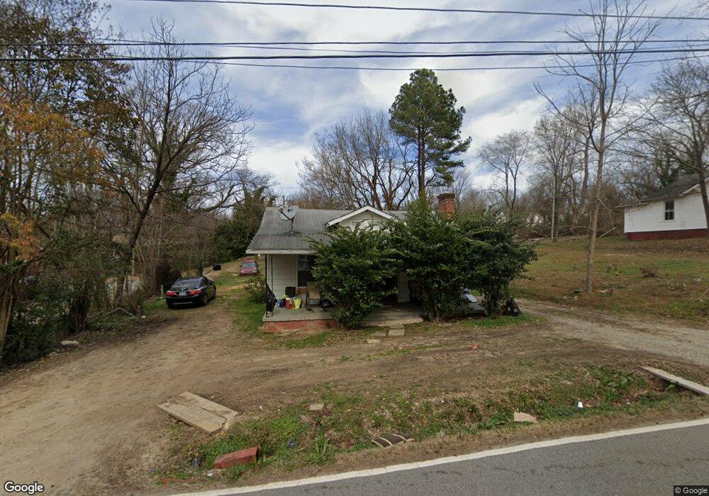
1211 E Russell Ave High Point, NC 27260
Greater High Point NeighborhoodEstimated Value: $117,718 - $169,000
2
Beds
1
Bath
910
Sq Ft
$149/Sq Ft
Est. Value
About This Home
This home is located at 1211 E Russell Ave, High Point, NC 27260 and is currently estimated at $135,680, approximately $149 per square foot. 1211 E Russell Ave is a home located in Guilford County with nearby schools including Fairview Elementary School, Ferndale Middle School, and High Point Central High School.
Ownership History
Date
Name
Owned For
Owner Type
Purchase Details
Closed on
Mar 11, 2019
Sold by
Mayo Shawn A and Mayo Carmen C
Bought by
Chang Garcia Joshua David
Current Estimated Value
Purchase Details
Closed on
Sep 9, 2000
Sold by
Taylor Rosye K and Taylor William A
Bought by
Mayo Shawn A and Mayo Carmen C
Home Financials for this Owner
Home Financials are based on the most recent Mortgage that was taken out on this home.
Original Mortgage
$34,000
Interest Rate
7.92%
Create a Home Valuation Report for This Property
The Home Valuation Report is an in-depth analysis detailing your home's value as well as a comparison with similar homes in the area
Home Values in the Area
Average Home Value in this Area
Purchase History
| Date | Buyer | Sale Price | Title Company |
|---|---|---|---|
| Chang Garcia Joshua David | $8,000 | None Available | |
| Mayo Shawn A | $46,500 | -- |
Source: Public Records
Mortgage History
| Date | Status | Borrower | Loan Amount |
|---|---|---|---|
| Previous Owner | Mayo Shawn A | $34,000 | |
| Closed | Mayo Shawn A | $10,000 |
Source: Public Records
Tax History Compared to Growth
Tax History
| Year | Tax Paid | Tax Assessment Tax Assessment Total Assessment is a certain percentage of the fair market value that is determined by local assessors to be the total taxable value of land and additions on the property. | Land | Improvement |
|---|---|---|---|---|
| 2025 | $493 | $35,800 | $5,000 | $30,800 |
| 2024 | $493 | $35,800 | $5,000 | $30,800 |
| 2023 | $493 | $35,800 | $5,000 | $30,800 |
| 2022 | $483 | $35,800 | $5,000 | $30,800 |
| 2021 | $350 | $25,400 | $4,000 | $21,400 |
| 2020 | $350 | $25,400 | $4,000 | $21,400 |
| 2019 | $350 | $25,400 | $0 | $0 |
| 2018 | $348 | $25,400 | $0 | $0 |
| 2017 | $348 | $25,400 | $0 | $0 |
| 2016 | $404 | $28,800 | $0 | $0 |
| 2015 | $406 | $28,800 | $0 | $0 |
| 2014 | $413 | $28,800 | $0 | $0 |
Source: Public Records
Map
Nearby Homes
- 1208 Anderson Place
- 640 Wesley Dr
- 901 Richland St
- 650 Wesley Dr
- 511 Hines St
- 507 Hines St
- 1907 Apex Place
- 1423 E Commerce Ave
- 1222 Carter St
- 518 Whiteoak St
- 809 E Green Dr
- 517 Walnut St
- 527 Smith St Unit A & B
- 1010 Grace St
- 402 Walnut St
- 909 Sharon St
- 523/525 Smith St
- 1035 Asheboro St
- 507 Grimes Ave
- 702 Park St
- 1213 E Russell Ave
- 1209 E Russell Ave
- 1215 E Russell Ave
- 1310 Ragan Ave
- 1308 Ragan Ave
- 1217 E Russell Ave
- 1312 Ragan Ave
- 1400 Ragan Ave
- 1306 Ragan Ave
- 1309 Pershing St
- 1311 Pershing St
- 1210 E Russell Ave
- 1208 E Russell Ave
- 1307 Pershing St
- 1212 E Russell Ave
- 1402 Ragan Ave
- 1219 E Russell Ave
- 1305 Pershing St
- 1401 Pershing St
- 1216 E Russell Ave