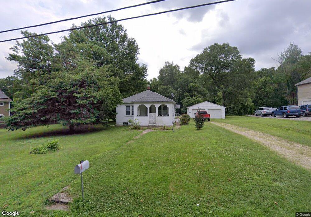
1211 Furnace Rd Linthicum Heights, MD 21090
Estimated Value: $407,000 - $503,000
--
Bed
1
Bath
1,560
Sq Ft
$283/Sq Ft
Est. Value
About This Home
This home is located at 1211 Furnace Rd, Linthicum Heights, MD 21090 and is currently estimated at $440,859, approximately $282 per square foot. 1211 Furnace Rd is a home located in Anne Arundel County with nearby schools including Overlook Elementary School, Lindale Middle School, and North County High School.
Ownership History
Date
Name
Owned For
Owner Type
Purchase Details
Closed on
Jan 20, 2016
Sold by
Peterson Dane M and Peterson Irene P M
Bought by
Conway Ernest A and Johnson Odette F
Current Estimated Value
Home Financials for this Owner
Home Financials are based on the most recent Mortgage that was taken out on this home.
Original Mortgage
$97,200
Outstanding Balance
$77,356
Interest Rate
3.98%
Mortgage Type
New Conventional
Estimated Equity
$363,503
Purchase Details
Closed on
Oct 1, 1990
Sold by
Mitter Guy L
Bought by
Peterson Dane M and Peterson Irene P M
Home Financials for this Owner
Home Financials are based on the most recent Mortgage that was taken out on this home.
Original Mortgage
$112,300
Interest Rate
10.22%
Create a Home Valuation Report for This Property
The Home Valuation Report is an in-depth analysis detailing your home's value as well as a comparison with similar homes in the area
Home Values in the Area
Average Home Value in this Area
Purchase History
| Date | Buyer | Sale Price | Title Company |
|---|---|---|---|
| Conway Ernest A | $108,000 | None Available | |
| Peterson Dane M | $109,900 | -- |
Source: Public Records
Mortgage History
| Date | Status | Borrower | Loan Amount |
|---|---|---|---|
| Open | Conway Ernest A | $97,200 | |
| Previous Owner | Peterson Dane M | $112,300 |
Source: Public Records
Tax History Compared to Growth
Tax History
| Year | Tax Paid | Tax Assessment Tax Assessment Total Assessment is a certain percentage of the fair market value that is determined by local assessors to be the total taxable value of land and additions on the property. | Land | Improvement |
|---|---|---|---|---|
| 2025 | $2,289 | $362,100 | $212,800 | $149,300 |
| 2024 | $2,289 | $347,033 | $0 | $0 |
| 2023 | $2,204 | $331,967 | $0 | $0 |
| 2022 | $2,044 | $316,900 | $187,800 | $129,100 |
| 2021 | $3,998 | $256,733 | $0 | $0 |
| 2020 | $1,915 | $196,567 | $0 | $0 |
| 2019 | $1,875 | $136,400 | $86,400 | $50,000 |
| 2018 | $1,383 | $136,400 | $86,400 | $50,000 |
| 2017 | $1,833 | $136,400 | $0 | $0 |
| 2016 | -- | $144,700 | $0 | $0 |
| 2015 | -- | $138,433 | $0 | $0 |
| 2014 | -- | $132,167 | $0 | $0 |
Source: Public Records
Map
Nearby Homes
- 1401 Furnace Rd
- 1200 Old Elkridge Landing Rd
- 1006 & 1008 Old Elkridge Landing Dr
- 6300 Buck Cavey Ln
- 5757 Elkridge Heights Rd
- 1807 Sutton Ave
- 1811 Palo Cir
- 6222 Woodland Rd
- 6246 Woodland Rd
- 1319 German Driveway
- 6811 Morrow Mountain Rd
- 1333 German Driveway
- 5901 Rustic Ln
- 107 Michael Ave
- 1337 German Driveway
- 6025 Hosta Ct
- 437 Kingwood Rd
- 5712 Richardson Mews Square
- 19 Piedmont Ct
- 6502 Whitetail Crossing Way
- 1215 Furnace Rd
- 1209 Furnace Rd
- 1221 Furnace Rd
- 1217 Furnace Rd
- 1210 Furnace Rd
- 1205 Furnace Rd
- 1203 Furnace Rd
- 1222 Furnace Rd
- 1206 Furnace Rd
- 1300 Furnace Rd
- 1201 Furnace Rd
- 1301 Furnace Rd
- 1303 Furnace Rd
- 1226 Furnace Rd
- 1302 Furnace Rd
- 1200 Furnace Rd
- 1305 Furnace Rd
- 1123 Furnace Rd
- 1125 Furnace Rd
- 1185 Furnace Rd