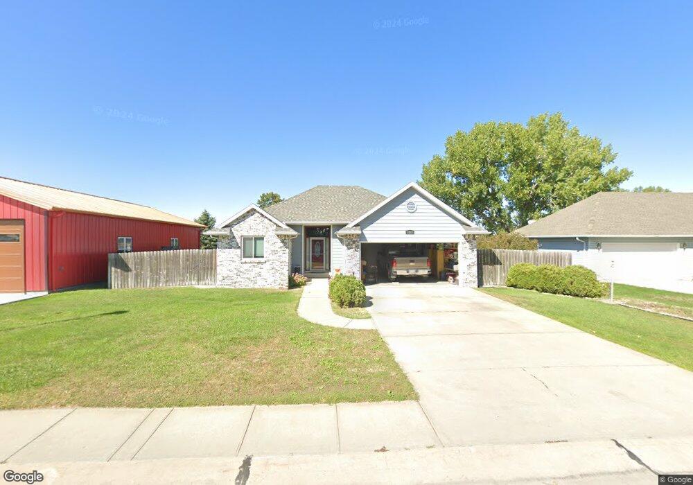
1211 Hackberry Rd North Platte, NE 69101
Estimated Value: $258,210 - $368,000
3
Beds
2
Baths
1,352
Sq Ft
$225/Sq Ft
Est. Value
About This Home
This home is located at 1211 Hackberry Rd, North Platte, NE 69101 and is currently estimated at $304,303, approximately $225 per square foot. 1211 Hackberry Rd is a home located in Lincoln County with nearby schools including North Platte High School, Mc Daid Elementary School, and Our Redeemer Lutheran School.
Ownership History
Date
Name
Owned For
Owner Type
Purchase Details
Closed on
Sep 23, 2025
Sold by
Flott Michael C and Flott Danilyn O
Bought by
Perry David W and Perry Joan M
Current Estimated Value
Purchase Details
Closed on
Feb 1, 2022
Sold by
Kimball Darrel C
Bought by
Flott Michael C
Purchase Details
Closed on
Apr 23, 2008
Sold by
Florea Beverly R
Bought by
Kimball Darrel C
Home Financials for this Owner
Home Financials are based on the most recent Mortgage that was taken out on this home.
Original Mortgage
$100,000
Interest Rate
6.11%
Mortgage Type
New Conventional
Purchase Details
Closed on
Feb 6, 2007
Sold by
Funston Richard N
Bought by
Florea Beverly R
Home Financials for this Owner
Home Financials are based on the most recent Mortgage that was taken out on this home.
Original Mortgage
$175,000
Interest Rate
6.21%
Mortgage Type
Future Advance Clause Open End Mortgage
Create a Home Valuation Report for This Property
The Home Valuation Report is an in-depth analysis detailing your home's value as well as a comparison with similar homes in the area
Home Values in the Area
Average Home Value in this Area
Purchase History
| Date | Buyer | Sale Price | Title Company |
|---|---|---|---|
| Perry David W | $330,000 | Title Services Of The Plains | |
| Flott Michael C | $497 | Western Title | |
| Kimball Darrel C | $164,000 | None Available | |
| Florea Beverly R | $111,000 | None Available |
Source: Public Records
Mortgage History
| Date | Status | Borrower | Loan Amount |
|---|---|---|---|
| Previous Owner | Kimball Darrel C | $100,000 | |
| Previous Owner | Florea Beverly R | $175,000 |
Source: Public Records
Tax History
| Year | Tax Paid | Tax Assessment Tax Assessment Total Assessment is a certain percentage of the fair market value that is determined by local assessors to be the total taxable value of land and additions on the property. | Land | Improvement |
|---|---|---|---|---|
| 2025 | $3,651 | $254,497 | $33,866 | $220,631 |
| 2024 | $3,651 | $254,497 | $33,866 | $220,631 |
| 2023 | $3,136 | $171,999 | $20,120 | $151,879 |
| 2022 | $2,875 | $148,793 | $18,039 | $130,754 |
| 2021 | $850 | $143,070 | $17,345 | $125,725 |
| 2020 | $889 | $143,070 | $17,345 | $125,725 |
| 2019 | $989 | $143,070 | $17,345 | $125,725 |
| 2018 | $1,667 | $143,070 | $17,345 | $125,725 |
| 2017 | $2,808 | $141,560 | $17,345 | $124,215 |
| 2016 | $2,683 | $132,900 | $17,345 | $115,555 |
| 2014 | $2,974 | $133,160 | $17,345 | $115,815 |
Source: Public Records
Map
Nearby Homes
- 2901 S Oak St
- 3102 S Oak St
- 910 W Walker Rd
- 0 N Platte Fremont Slough Development Unit 11573268
- N Platte Unit NE 69101
- 3366 Parker Rd
- 1306 William Ave
- 0 Unit Lot
- TBD Sioux Meadows Dr
- 918 W Reid Ave
- 909 W Reid Ave
- 1401 S Buffalo Bill Ave
- 1213 William Ct
- 0 N Buffalo Bill Grass
- N Platte Unit NE 69101
- 906 W Phillip St
- 1211 S Buffalo Bill Ave
- 0 Buffalo Triangle Frontage
- 0 State Farm Road Short Acreage W
- 0 State Farm Road Short Acreage E
- 1301 Hackberry Rd
- 1201 Hackberry Rd
- 1220 Hackberry Rd
- 1121 Hackberry Rd
- 1210 Hackberry Rd
- 1202 Hackberry Rd
- 1302 Hackberry Rd
- 1311 Hackberry Rd
- 1119 Hackberry Rd
- 1120 Hackberry Rd
- 1315 Hackberry Rd
- 1117 Hackberry Rd
- 1201 W Eugene Ave
- 1110 Hackberry Rd
- 1320 Hackberry Rd
- 1321 Hackberry Rd
- 1121 W Eugene Ave
- 2702 Lynn Ct
- 1106 Hackberry Rd
- 1221 W Eugene Ave Unit 1223
Your Personal Tour Guide
Ask me questions while you tour the home.