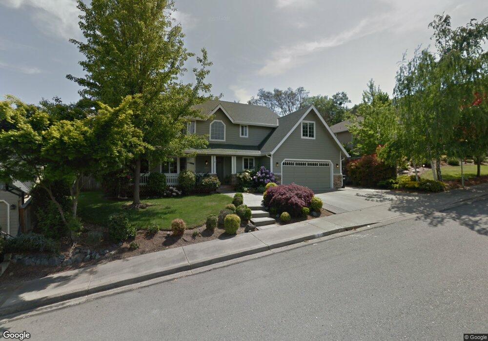
1211 NW Cooke Ave Grants Pass, OR 97526
Estimated Value: $545,342 - $691,000
3
Beds
3
Baths
2,288
Sq Ft
$270/Sq Ft
Est. Value
About This Home
This home is located at 1211 NW Cooke Ave, Grants Pass, OR 97526 and is currently estimated at $618,171, approximately $270 per square foot. 1211 NW Cooke Ave is a home located in Josephine County with nearby schools including Highland Elementary School, North Middle School, and Grants Pass High School.
Ownership History
Date
Name
Owned For
Owner Type
Purchase Details
Closed on
Mar 15, 2024
Sold by
Atondo Paul M and Atondo Susanne E
Bought by
Atondo Family Revocable Trust and Atondo
Current Estimated Value
Purchase Details
Closed on
Jun 5, 2017
Sold by
Dole James R and Dole Janice S
Bought by
Atondo Paul M and Atondo Susanne E
Home Financials for this Owner
Home Financials are based on the most recent Mortgage that was taken out on this home.
Original Mortgage
$387,000
Interest Rate
4.02%
Mortgage Type
New Conventional
Create a Home Valuation Report for This Property
The Home Valuation Report is an in-depth analysis detailing your home's value as well as a comparison with similar homes in the area
Home Values in the Area
Average Home Value in this Area
Purchase History
| Date | Buyer | Sale Price | Title Company |
|---|---|---|---|
| Atondo Family Revocable Trust | -- | None Listed On Document | |
| Atondo Paul M | $430,000 | First American |
Source: Public Records
Mortgage History
| Date | Status | Borrower | Loan Amount |
|---|---|---|---|
| Previous Owner | Atondo Paul M | $387,000 |
Source: Public Records
Tax History Compared to Growth
Tax History
| Year | Tax Paid | Tax Assessment Tax Assessment Total Assessment is a certain percentage of the fair market value that is determined by local assessors to be the total taxable value of land and additions on the property. | Land | Improvement |
|---|---|---|---|---|
| 2025 | $4,761 | $366,620 | -- | -- |
| 2024 | $4,761 | $355,950 | -- | -- |
| 2023 | $4,623 | $345,590 | $0 | $0 |
| 2022 | $4,506 | $335,530 | -- | -- |
| 2021 | $4,232 | $325,760 | $0 | $0 |
| 2020 | $4,110 | $316,280 | $0 | $0 |
| 2019 | $3,991 | $307,070 | $0 | $0 |
| 2018 | $4,061 | $298,130 | $0 | $0 |
| 2017 | $4,031 | $289,450 | $0 | $0 |
| 2016 | $3,543 | $281,020 | $0 | $0 |
| 2015 | $3,428 | $272,840 | $0 | $0 |
| 2014 | $3,333 | $264,900 | $0 | $0 |
Source: Public Records
Map
Nearby Homes
- 1946 NW Crown St
- 1126 NW Morgan Ln
- 2034 NW Sarum Cir
- 1285 NW Cooke Ave
- 1137 Sunburst Way
- 1024 NW Cooke Ave
- 1805 NW Candler Ave
- 1172 NW Starlite Place
- 2203 NW Juliet Ln
- 908 NW Bishop St
- 1162 NW Starlite Place
- 1129 NW Starlite Place
- 107 NW Wrightwood Cir
- 214 NW Creekside Dr
- 210 NW Woodbrook Dr
- 1085 NW Starlite Place Unit R342008
- 201 NW Creekside Dr
- 208 NW Creekside Dr
- 206 NW Creekside Dr
- 416 NW Pleasant View Dr
- 1215 NW Cooke Ave
- 1205 NW Cooke Ave
- 1964 NW Crown St
- 1221 NW Cooke Ave
- 1210 NW Cooke Ave
- 1952 NW Crown St
- 1214 NW Cooke Ave
- 2000 NW Crown St
- 1958 NW Crown St
- 1165 NW Cooke Ave
- 1965 NW Crown St
- 1225 NW Cooke Ave
- 1213 NW Salisbury Dr
- 1224 NW Cooke Ave
- 1959 NW Crown St
- 1203 NW Salisbury Dr
- 1223 NW Salisbury Dr
- 2001 NW Crown St
- 1155 NW Cooke Ave
- 1953 NW Crown St