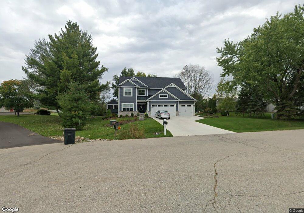
12110 187th Ave Bristol, WI 53104
Estimated Value: $546,000 - $863,907
4
Beds
3
Baths
2,412
Sq Ft
$282/Sq Ft
Est. Value
About This Home
This home is located at 12110 187th Ave, Bristol, WI 53104 and is currently estimated at $680,727, approximately $282 per square foot. 12110 187th Ave is a home with nearby schools including Bristol Elementary School and Central High School.
Ownership History
Date
Name
Owned For
Owner Type
Purchase Details
Closed on
May 23, 2019
Sold by
Kosycarz Henry
Bought by
Graham John R and Graham Jane E
Current Estimated Value
Home Financials for this Owner
Home Financials are based on the most recent Mortgage that was taken out on this home.
Original Mortgage
$92,000
Outstanding Balance
$80,556
Interest Rate
4%
Mortgage Type
New Conventional
Estimated Equity
$600,171
Purchase Details
Closed on
Mar 9, 2009
Sold by
Kosycarz Wieslawa
Bought by
Kosycarz Henry
Create a Home Valuation Report for This Property
The Home Valuation Report is an in-depth analysis detailing your home's value as well as a comparison with similar homes in the area
Home Values in the Area
Average Home Value in this Area
Purchase History
| Date | Buyer | Sale Price | Title Company |
|---|---|---|---|
| Graham John R | $115,000 | Blackhawk Title | |
| Kosycarz Henry | -- | Blackhawk Title |
Source: Public Records
Mortgage History
| Date | Status | Borrower | Loan Amount |
|---|---|---|---|
| Open | Graham John R | $92,000 |
Source: Public Records
Tax History Compared to Growth
Tax History
| Year | Tax Paid | Tax Assessment Tax Assessment Total Assessment is a certain percentage of the fair market value that is determined by local assessors to be the total taxable value of land and additions on the property. | Land | Improvement |
|---|---|---|---|---|
| 2024 | $8,348 | $449,500 | $115,000 | $334,500 |
| 2023 | $7,111 | $449,500 | $115,000 | $334,500 |
| 2022 | $7,124 | $449,500 | $115,000 | $334,500 |
| 2021 | $2,063 | $115,000 | $115,000 | $0 |
| 2020 | $1,903 | $115,000 | $115,000 | $0 |
| 2019 | $1,805 | $115,000 | $115,000 | $0 |
| 2018 | $935 | $48,000 | $48,000 | $0 |
| 2017 | $954 | $48,000 | $48,000 | $0 |
| 2016 | $936 | $48,000 | $48,000 | $0 |
| 2015 | $881 | $48,000 | $48,000 | $0 |
| 2014 | -- | $48,000 | $48,000 | $0 |
Source: Public Records
Map
Nearby Homes
- 11944 187th Ave
- 18828 116th St
- 19900 128th St Unit 210
- 19900 128th St Unit 70
- 19900 128th St Unit 124
- 19900 128th St Unit 150
- 19900 128th St Unit 317
- 19900 128th St Unit 39
- 19900 128th St Unit 44
- 19900 128th St Unit 121
- 18290 Winfield Rd
- 42909 N Deep Lake Rd
- Lt0 128th St
- 18939 W State Line Rd
- 21605 117th St
- 18863 W State Line Rd
- 1062 Neuhaven Dr
- 1056 Deertrail Ct
- 1063 Joy Ct
- 1214 Jerome Ct
- 12200 187th Ave
- 12100 187th Ave
- 12020 187th Ave
- 11970 187th Ave
- 11958 187th Ave
- 18512 120th St
- 18512 120th St
- 11945 187th Ave
- 11935 187th Ave
- 11935 187th Ave
- 11924 187th Ave
- 18402 120th St
- 18402 120th St Unit 18402
- 11914 187th Ave
- 18319 120th St
- 18319 120th St
- 18304 120th St
- 11919 184th Ave
- 11919 184th Ave
- 18800 128th St