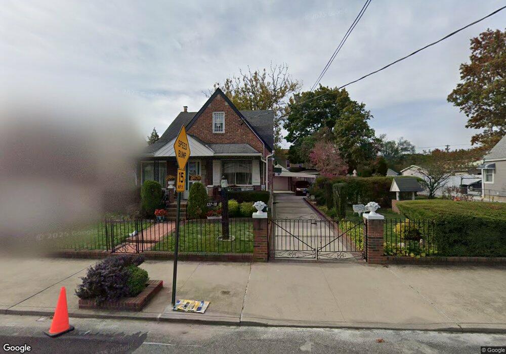
12118 Milburn St Springfield Gardens, NY 11413
Saint Albans NeighborhoodEstimated Value: $697,192 - $903,000
--
Bed
--
Bath
1,492
Sq Ft
$544/Sq Ft
Est. Value
About This Home
This home is located at 12118 Milburn St, Springfield Gardens, NY 11413 and is currently estimated at $811,548, approximately $543 per square foot. 12118 Milburn St is a home located in Queens County with nearby schools including P.S. 15 Jackie Robinson, Is 59 Springfield Gardens, and Success Academy Springfield Gardens.
Ownership History
Date
Name
Owned For
Owner Type
Purchase Details
Closed on
Jun 7, 2012
Sold by
Senn Donald and Senn Thelma
Bought by
Donald A Senn and Michelle Grezinsky Trustee
Current Estimated Value
Purchase Details
Closed on
Sep 14, 1995
Sold by
Senn Donald and Senn Thelma
Bought by
Senn Donald and Senn Thelma
Create a Home Valuation Report for This Property
The Home Valuation Report is an in-depth analysis detailing your home's value as well as a comparison with similar homes in the area
Home Values in the Area
Average Home Value in this Area
Purchase History
| Date | Buyer | Sale Price | Title Company |
|---|---|---|---|
| Donald A Senn | -- | -- | |
| Donald A Senn | -- | -- | |
| Senn Donald | -- | First American Title Ins Co | |
| Senn Donald | -- | First American Title Ins Co |
Source: Public Records
Tax History Compared to Growth
Tax History
| Year | Tax Paid | Tax Assessment Tax Assessment Total Assessment is a certain percentage of the fair market value that is determined by local assessors to be the total taxable value of land and additions on the property. | Land | Improvement |
|---|---|---|---|---|
| 2025 | $2,521 | $34,666 | $13,914 | $20,752 |
| 2024 | $2,625 | $32,704 | $14,057 | $18,647 |
| 2023 | $2,335 | $30,854 | $13,750 | $17,104 |
| 2022 | $2,242 | $41,160 | $17,460 | $23,700 |
| 2021 | $2,563 | $36,600 | $17,460 | $19,140 |
| 2020 | $5,456 | $36,000 | $17,460 | $18,540 |
| 2019 | $2,191 | $33,120 | $17,460 | $15,660 |
| 2018 | $5,379 | $25,712 | $12,470 | $13,242 |
| 2017 | $1,974 | $25,704 | $14,274 | $11,430 |
| 2016 | $4,791 | $25,704 | $14,274 | $11,430 |
| 2015 | -- | $24,073 | $14,022 | $10,051 |
Source: Public Records
Map
Nearby Homes
- 12133 Grayson St
- 188-51 120th Rd
- 122-22 Nellis St
- 179-47 Zoller Rd
- 179-50 Anderson Rd
- 17955 Anderson Rd
- 191-07 121st Ave
- 12244 Nellis St
- 19009 122nd Ave
- 12253 Milburn St
- 12251 Grayson St
- 12248 Benton St
- 191-01 122nd Ave
- 17915 Eveleth Rd
- 122-66 Nellis St
- 17911 Eveleth Rd
- 120-44 192nd St
- 12811 Harry Douglass Way
- 179-01 120th Ave
- 17918 Selover Rd
- 12122 Milburn St
- 12112 Milburn St
- 121-12 Milburn St
- 12126 Milburn St
- 12117 Farmers Blvd
- 12111 Farmers Blvd
- 18710 121st Ave
- 12107 Farmers Blvd
- 18714 121st Ave
- 12130 Milburn St
- 121-25 Farmers Blvd
- 12125 Farmers Blvd
- 18710 121st Ave
- 12117 Milburn St
- 12121 Milburn St
- 12111 Milburn St
- 12111 Milburn St
- 121-17 Milburn St
- 12127 Milburn St
- 121-03 Farmers Blvd