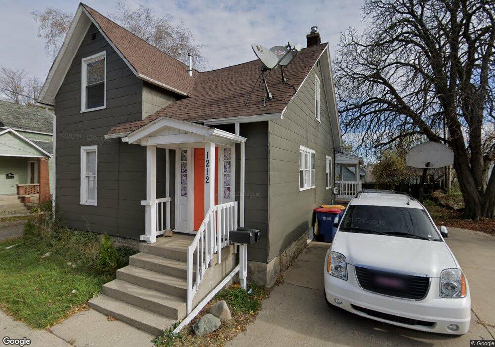
1212 Wieland Plc Grand Rapids, MI 49504
West Grand NeighborhoodEstimated Value: $201,000 - $266,000
--
Bed
2
Baths
1,686
Sq Ft
$139/Sq Ft
Est. Value
About This Home
This home is located at 1212 Wieland Plc, Grand Rapids, MI 49504 and is currently estimated at $233,799, approximately $138 per square foot. 1212 Wieland Plc is a home located in Kent County with nearby schools including Harrison Elementary School, Westwood Middle School, and Union High School.
Ownership History
Date
Name
Owned For
Owner Type
Purchase Details
Closed on
Dec 13, 2016
Sold by
Roelofs Thomas J
Bought by
Beckett Mike Robert and Beckett Rebecca
Current Estimated Value
Purchase Details
Closed on
Jun 17, 2014
Sold by
Droski Joann M
Bought by
Roelofs Thomas J
Create a Home Valuation Report for This Property
The Home Valuation Report is an in-depth analysis detailing your home's value as well as a comparison with similar homes in the area
Home Values in the Area
Average Home Value in this Area
Purchase History
| Date | Buyer | Sale Price | Title Company |
|---|---|---|---|
| Beckett Mike Robert | $50,000 | None Available | |
| Roelofs Thomas J | $27,000 | None Available |
Source: Public Records
Tax History Compared to Growth
Tax History
| Year | Tax Paid | Tax Assessment Tax Assessment Total Assessment is a certain percentage of the fair market value that is determined by local assessors to be the total taxable value of land and additions on the property. | Land | Improvement |
|---|---|---|---|---|
| 2025 | $2,130 | $101,800 | $0 | $0 |
| 2024 | $2,130 | $95,400 | $0 | $0 |
| 2023 | $2,036 | $72,600 | $0 | $0 |
| 2022 | $2,008 | $66,500 | $0 | $0 |
| 2021 | $2,327 | $57,000 | $0 | $0 |
| 2020 | $2,431 | $49,200 | $0 | $0 |
| 2019 | $1,877 | $46,400 | $0 | $0 |
| 2018 | $1,877 | $36,800 | $0 | $0 |
| 2017 | $1,831 | $29,500 | $0 | $0 |
| 2016 | $1,454 | $27,100 | $0 | $0 |
| 2015 | $1,385 | $27,100 | $0 | $0 |
| 2013 | -- | $25,200 | $0 | $0 |
Source: Public Records
Map
Nearby Homes
- 1124 Hamilton Ave NW
- 1328 Broadway Ave NW
- 1351 Hamilton Ave NW
- 1331 Turner Ave NW
- 1253 Muskegon Ave NW
- 1044 Muskegon Ave NW Unit 1 & 2
- 1014 Hamilton Ave NW
- 1011 Hamilton Ave NW
- 1435 Broadway Ave NW
- 638 11th St NW
- 734 Crosby St NW
- 936 Mcreynolds Ave NW
- 1032 Jennette Ave NW
- 1014 Jennette Ave NW
- 1027 Jennette Ave NW
- 855 Alpine Ave NW
- 912 Arianna St NW
- 815 Mcreynolds Ave NW
- 1528 Alpine Ave NW
- 914 Courtney St NW
- 1212 Wieland Place NW
- 1218 Wieland Place NW
- 1222 Wieland Place NW
- 1211 Hamilton Ave NW
- 1207 Hamilton Ave NW
- 503 Leonard St NW
- 1226 Quarry Ave NW
- 1232 Wieland Place NW
- 1231 Hamilton Ave NW
- 1236 Wieland Place NW
- 455 Leonard St NW
- 1234 Quarry Ave NW
- 1235 Hamilton Ave NW
- 512 Leonard St NW
- 524 Leonard St NW
- 1214 Hamilton Ave NW
- 1214 Hamilton Ave NW Unit 1-4
- 1215 Quarry Ave NW
- 506 Leonard St NW
- 1220 Hamilton Ave NW